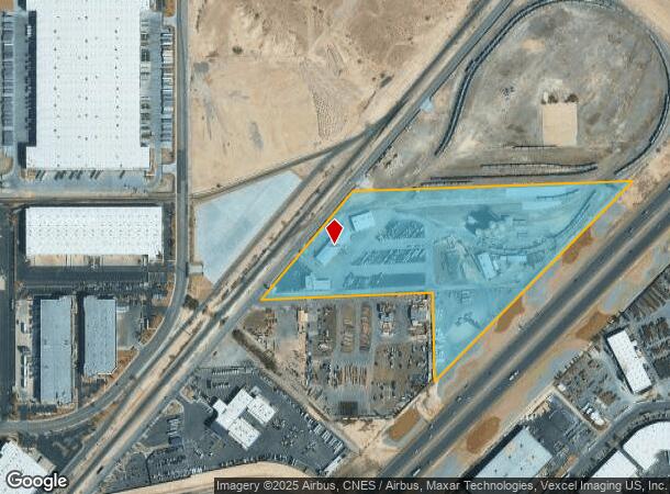
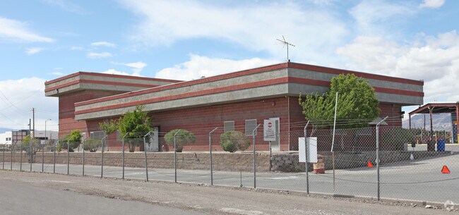
Property Record
4910 Donovan Way, North Las Vegas, NV 89081

NEARBY LISTINGS FOR SALE OR LEASE
Property Detail
4910 Donovan Way
Las Vegas-Henderson-Paradise, NV
Parcel Map File 79 Page 47
123-31-402-006
PARCEL MAP FILE 79 PAGE 47 LOT 1 & PT SE4 SW4 SEC 31 19 62
Shipyard
Clark
X
Nevada
32003C2176F
1
2025
24.81 AC
2025
North Las Vegas
003649
Las Vegas
39,454 SF
DEMOGRAPHICS near 4910 Donovan Way
1 Mile
3 Mile
5 Mile
2024 Total Population
4,986
129,276
320,310
2029 Population
5,313
139,084
344,168
Pop Growth 2024-2029
+ 6.56%
+ 7.59%
+ 7.45%
Average Age
38
34
35
2024 Total Households
1,678
40,180
97,575
HH Growth 2024-2029
+ 6.50%
+ 7.55%
+ 7.47%
Median Household Inc
$67,631
$55,919
$54,681
Avg Household Size
3.00
3.10
3.10
2024 Avg HH Vehicles
2.00
2.00
2.00
Median Home Value
$334,215
$303,698
$288,473
Median Year Built
2004
2001
1996
Nearby Places
Map Layers
Map Styles
 Street
 Aerial
- Restaurants
- Banks
- Shops
- Fitness
- Groceries
PUBLIC TRANSPORTATION
AIRPORT
Harry Reid International
DRIVE
WALK
Distance
Harry Reid International
24 min
15.2 mi
Boulder City Municipal
DRIVE
WALK
Distance
Boulder City Municipal
45 min
31.7 mi
Freight Ports
Port of Long Beach
DRIVE
WALK
Distance
Port of Long Beach
325 min
290.7 mi
SALE & LEASE HISTORY
LISTING DATE
SALE/LEASE

Sep 24, 2016
For Lease
Nearby Properties
Address
Land Use
TOTAL SIZE
Lot Size
Zoning
Address
Land Use
TOTAL SIZE
Lot Size
Zoning
33,783 SF
168.44 AC
Address
Land Use
TOTAL SIZE
Lot Size
Zoning
1,767,948 SF
142.04 AC
Address
Land Use
TOTAL SIZE
Lot Size
Zoning
252,005 SF
27.94 AC
C3
Address
Land Use
TOTAL SIZE
Lot Size
Zoning
1,102,891 SF
84.43 AC
Address
Land Use
TOTAL SIZE
Lot Size
Zoning
798,660 SF
37.86 AC
M2
Address
Land Use
TOTAL SIZE
Lot Size
Zoning
813,120 SF
38.20 AC
Address
Land Use
TOTAL SIZE
Lot Size
Zoning
656,250 SF
29.11 AC
Address
Land Use
TOTAL SIZE
Lot Size
Zoning
51.45 AC
R1
Address
Land Use
TOTAL SIZE
Lot Size
Zoning
747,196 SF
40.03 AC
Address
Land Use
TOTAL SIZE
Lot Size
Zoning
632,224 SF
31.23 AC
Address
Land Use
TOTAL SIZE
Lot Size
Zoning
681,792 SF
29.65 AC
Address
Land Use
TOTAL SIZE
Lot Size
Zoning
621,824 SF
32.27 AC
Address
Land Use
TOTAL SIZE
Lot Size
Zoning
677,768 SF
31.52 AC
Address
Land Use
TOTAL SIZE
Lot Size
Zoning
696,064 SF
29.08 AC
Address
Land Use
TOTAL SIZE
Lot Size
Zoning
15,566 SF
48.39 AC
R4
Address
Land Use
TOTAL SIZE
Lot Size
Zoning
602,609 SF
27.33 AC
M2
Address
Land Use
TOTAL SIZE
Lot Size
Zoning
570,810 SF
29.73 AC
Address
Land Use
TOTAL SIZE
Lot Size
Zoning
625,804 SF
27.23 AC
Address
Land Use
TOTAL SIZE
Lot Size
Zoning
617,670 SF
27.90 AC
M2
Address
Land Use
TOTAL SIZE
Lot Size
Zoning
720,000 SF
25.07 AC
Address
Land Use
TOTAL SIZE
Lot Size
Zoning
3,735 SF
17.69 AC
R3
Address
Land Use
TOTAL SIZE
Lot Size
Zoning
478,096 SF
17.87 AC
R3
Address
Land Use
TOTAL SIZE
Lot Size
Zoning
509,586 SF
23.97 AC
Address
Land Use
TOTAL SIZE
Lot Size
Zoning
35.49 AC
RE
Address
Land Use
TOTAL SIZE
Lot Size
Zoning
438,601 SF
16.84 AC
R4
Address
Land Use
TOTAL SIZE
Lot Size
Zoning
546,249 SF
28.58 AC
Address
Land Use
TOTAL SIZE
Lot Size
Zoning
152,520 SF
42.31 AC
M2
Address
Land Use
TOTAL SIZE
Lot Size
Zoning
400,162 SF
26.77 AC
Address
Land Use
TOTAL SIZE
Lot Size
Zoning
463,680 SF
13.81 AC
The World's #1 Commercial Real Estate Marketplace
Connect with us
© 2025 CoStar Group
The information above has been obtained from sources believed reliable. While we do not doubt its accuracy we have not verified it and make no guarantee, warranty or representation about it. It is your responsibility to independently confirm its accuracy and completeness. Any projections, opinions, assumptions, or estimates used are for example only and do not represent the current or future performance of the property. The value of this transaction to you depends on tax and other factors which should be evaluated by your tax, financial, and legal advisors. You and your advisors should conduct a careful, independent investigation of the property to determine to your satisfaction the suitability of the property for your needs.