Property Record
4911 Fm 1960 Rd W, Houston, TX 77069
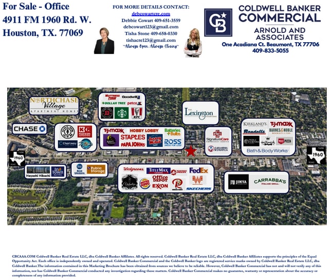

NEARBY LISTINGS FOR SALE OR LEASE
Property Detail
4911 Fm 1960 Rd W
1043410000020
Greenwood Forest Sec 3
Financialbuilding
RES H1 BLK 20 GREENWOOD FOREST SEC 3
X
Harris
48201C0435M
Texas
2024
1.65 AC
2025
Cypresswood Dr
551201
Houston
16,667 SF
Houston-Pasadena-The Woodlands, TX
DEMOGRAPHICS near 4911 Fm 1960 Rd W
1 Mile
3 Mile
5 Mile
2024 Total Population
18,294
110,295
309,883
2029 Population
18,742
112,150
314,633
Pop Growth 2024-2029
+ 2.45%
+ 1.68%
+ 1.53%
Average Age
38
38
37
2024 Total Households
7,019
38,830
107,844
HH Growth 2024-2029
+ 2.31%
+ 1.73%
+ 1.60%
Median Household Inc
$58,184
$66,477
$62,095
Avg Household Size
2.50
2.80
2.80
2024 Avg HH Vehicles
2.00
2.00
2.00
Median Home Value
$244,471
$242,116
$226,319
Median Year Built
1981
1987
1989
Nearby Places
Map Layers
Map Styles
 Street
 Aerial
- Restaurants
- Banks
- Shops
- Fitness
- Groceries
PUBLIC TRANSPORTATION
AIRPORT
George Bush Intcntl/Houston
DRIVE
WALK
Distance
George Bush Intcntl/Houston
22 min
15.5 mi
William P Hobby
DRIVE
WALK
Distance
William P Hobby
50 min
31.1 mi
Freight Ports
Port of Houston
DRIVE
WALK
Distance
Port of Houston
42 min
26.6 mi
SALE & LEASE HISTORY
LISTING DATE
SALE/LEASE

May 27, 2025
For Sale
Nearby Properties
Address
Land Use
TOTAL SIZE
Lot Size
Zoning
Address
Land Use
TOTAL SIZE
Lot Size
Zoning
587,609 SF
42.44 AC
Address
Land Use
TOTAL SIZE
Lot Size
Zoning
445,343 SF
37.78 AC
Address
Land Use
TOTAL SIZE
Lot Size
Zoning
180,249 SF
13.35 AC
Address
Land Use
TOTAL SIZE
Lot Size
Zoning
402,504 SF
31.93 AC
Address
Land Use
TOTAL SIZE
Lot Size
Zoning
339,477 SF
13.54 AC
Address
Land Use
TOTAL SIZE
Lot Size
Zoning
286,090 SF
13.25 AC
Address
Land Use
TOTAL SIZE
Lot Size
Zoning
486,739 SF
19.92 AC
Address
Land Use
TOTAL SIZE
Lot Size
Zoning
423,472 SF
28.91 AC
Address
Land Use
TOTAL SIZE
Lot Size
Zoning
351,235 SF
20.73 AC
Address
Land Use
TOTAL SIZE
Lot Size
Zoning
377,188 SF
16.80 AC
Address
Land Use
TOTAL SIZE
Lot Size
Zoning
348,658 SF
16.72 AC
Address
Land Use
TOTAL SIZE
Lot Size
Zoning
148,450 SF
18.26 AC
Address
Land Use
TOTAL SIZE
Lot Size
Zoning
335,106 SF
13.27 AC
Address
Land Use
TOTAL SIZE
Lot Size
Zoning
295,201 SF
14.31 AC
Address
Land Use
TOTAL SIZE
Lot Size
Zoning
304,518 SF
15 AC
Address
Land Use
TOTAL SIZE
Lot Size
Zoning
329,812 SF
19.14 AC
Address
Land Use
TOTAL SIZE
Lot Size
Zoning
293,280 SF
16.24 AC
Address
Land Use
TOTAL SIZE
Lot Size
Zoning
234,512 SF
11.09 AC
Address
Land Use
TOTAL SIZE
Lot Size
Zoning
222,479 SF
4.82 AC
Address
Land Use
TOTAL SIZE
Lot Size
Zoning
130,470 SF
9.22 AC
Address
Land Use
TOTAL SIZE
Lot Size
Zoning
241,946 SF
14.02 AC
Address
Land Use
TOTAL SIZE
Lot Size
Zoning
237,292 SF
11.91 AC
Address
Land Use
TOTAL SIZE
Lot Size
Zoning
239,217 SF
14.74 AC
Address
Land Use
TOTAL SIZE
Lot Size
Zoning
247,670 SF
13.38 AC
Address
Land Use
TOTAL SIZE
Lot Size
Zoning
217,594 SF
8.26 AC
Address
Land Use
TOTAL SIZE
Lot Size
Zoning
348,857 SF
20.06 AC
Address
Land Use
TOTAL SIZE
Lot Size
Zoning
246,999 SF
9.27 AC
Address
Land Use
TOTAL SIZE
Lot Size
Zoning
211,200 SF
8.10 AC
Address
Land Use
TOTAL SIZE
Lot Size
Zoning
268,232 SF
12.33 AC
Address
Land Use
TOTAL SIZE
Lot Size
Zoning
221,352 SF
17.35 AC
The World's #1 Commercial Real Estate Marketplace
Connect with us
© 2026 CoStar Group
The information above has been obtained from sources believed reliable. While we do not doubt its accuracy we have not verified it and make no guarantee, warranty or representation about it. It is your responsibility to independently confirm its accuracy and completeness. Any projections, opinions, assumptions, or estimates used are for example only and do not represent the current or future performance of the property. The value of this transaction to you depends on tax and other factors which should be evaluated by your tax, financial, and legal advisors. You and your advisors should conduct a careful, independent investigation of the property to determine to your satisfaction the suitability of the property for your needs.