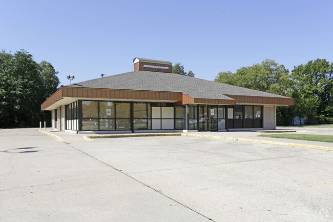
Property Record
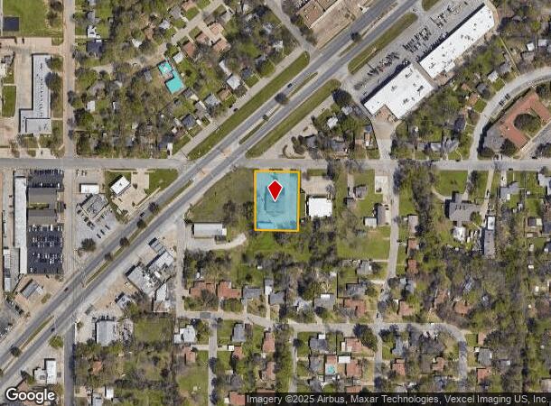
4913 Ohio Garden Rd, River Oaks, TX 76114
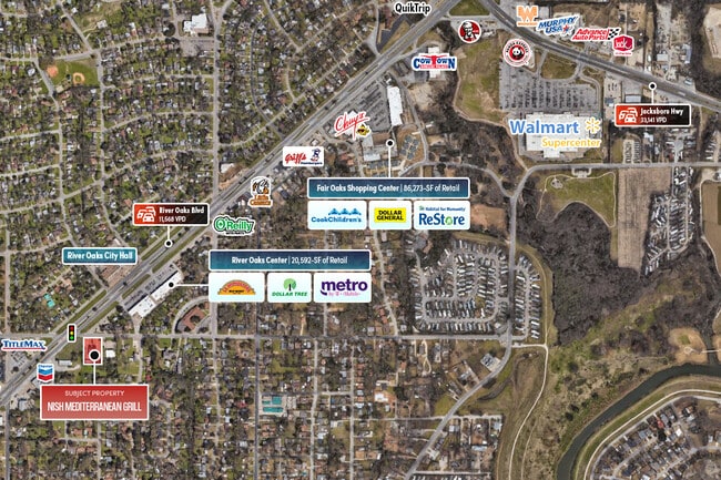
NEARBY LISTINGS FOR SALE OR LEASE
Property Detail
4913 Ohio Garden Rd
Dallas-Fort Worth-Arlington, TX
Ohio Garden - River Oaks Addn
42452846
OHIO GARDEN - RIVER OAKS ADDN BLOCK A LOT 2
Commercialnec
Tarrant
X
Texas
48439C0170L
2
2024
0.78 AC
2025
North Fort Worth
110500
Dallas/Ft Worth
3,370 SF
DEMOGRAPHICS near 4913 Ohio Garden Rd
1 Mile
3 Mile
5 Mile
2024 Total Population
12,007
88,443
229,579
2029 Population
12,674
93,752
244,245
Pop Growth 2024-2029
+ 5.56%
+ 6.00%
+ 6.39%
Average Age
37
37
37
2024 Total Households
4,218
32,959
88,685
HH Growth 2024-2029
+ 5.60%
+ 6.34%
+ 6.82%
Median Household Inc
$59,501
$59,595
$60,226
Avg Household Size
2.80
2.60
2.50
2024 Avg HH Vehicles
2.00
2.00
2.00
Median Home Value
$178,091
$225,805
$243,734
Median Year Built
1954
1966
1978
Nearby Places
Map Layers
Map Styles
 Street
 Aerial
- Restaurants
- Banks
- Shops
- Fitness
- Groceries
PUBLIC TRANSPORTATION
AIRPORT
Dallas-Fort Worth International
DRIVE
WALK
Distance
Dallas-Fort Worth International
39 min
29.3 mi
Freight Ports
Port of Shreveport
DRIVE
WALK
Distance
Port of Shreveport
1 min
221.4 mi
SALE & LEASE HISTORY
LISTING DATE
SALE/LEASE

Sep 18, 2017
For Sale
Sep 10, 2025
For Sale
Jul 26, 2017
For Sale
Jul 21, 2017
For Sale
Feb 14, 2018
For Lease
Apr 20, 2021
For Sale
Nearby Properties
Address
Land Use
TOTAL SIZE
Lot Size
Zoning
Address
Land Use
TOTAL SIZE
Lot Size
Zoning
802,865 SF
17.38 AC
Address
Land Use
TOTAL SIZE
Lot Size
Zoning
508,378 SF
6.02 AC
Address
Land Use
TOTAL SIZE
Lot Size
Zoning
205,807 SF
3.19 AC
Address
Land Use
TOTAL SIZE
Lot Size
Zoning
765,141 SF
56.28 AC
Address
Land Use
TOTAL SIZE
Lot Size
Zoning
336,310 SF
2.85 AC
Address
Land Use
TOTAL SIZE
Lot Size
Zoning
469,191 SF
4.20 AC
Address
Land Use
TOTAL SIZE
Lot Size
Zoning
462,036 SF
5.40 AC
Address
Land Use
TOTAL SIZE
Lot Size
Zoning
437,641 SF
6.60 AC
Address
Land Use
TOTAL SIZE
Lot Size
Zoning
411,395 SF
12.24 AC
Address
Land Use
TOTAL SIZE
Lot Size
Zoning
378,038 SF
7.01 AC
Address
Land Use
TOTAL SIZE
Lot Size
Zoning
401,487 SF
6.16 AC
Address
Land Use
TOTAL SIZE
Lot Size
Zoning
595,372 SF
12.24 AC
Address
Land Use
TOTAL SIZE
Lot Size
Zoning
307,139 SF
14.02 AC
Address
Land Use
TOTAL SIZE
Lot Size
Zoning
220,000 SF
9.92 AC
Address
Land Use
TOTAL SIZE
Lot Size
Zoning
531,597 SF
31.71 AC
Address
Land Use
TOTAL SIZE
Lot Size
Zoning
180,612 SF
Address
Land Use
TOTAL SIZE
Lot Size
Zoning
424,333 SF
12.59 AC
Address
Land Use
TOTAL SIZE
Lot Size
Zoning
183,899 SF
9.23 AC
Address
Land Use
TOTAL SIZE
Lot Size
Zoning
225,140 SF
11.68 AC
Address
Land Use
TOTAL SIZE
Lot Size
Zoning
232,014 SF
2.83 AC
Address
Land Use
TOTAL SIZE
Lot Size
Zoning
155,269 SF
Address
Land Use
TOTAL SIZE
Lot Size
Zoning
174,093 SF
0.14 AC
Address
Land Use
TOTAL SIZE
Lot Size
Zoning
338,214 SF
12.34 AC
Address
Land Use
TOTAL SIZE
Lot Size
Zoning
254,610 SF
15.92 AC
Address
Land Use
TOTAL SIZE
Lot Size
Zoning
184,611 SF
1.32 AC
Address
Land Use
TOTAL SIZE
Lot Size
Zoning
296,522 SF
7.80 AC
Address
Land Use
TOTAL SIZE
Lot Size
Zoning
137,500 SF
10.45 AC
Address
Land Use
TOTAL SIZE
Lot Size
Zoning
95,920 SF
3.13 AC
Address
Land Use
TOTAL SIZE
Lot Size
Zoning
91,398 SF
3.48 AC
Address
Land Use
TOTAL SIZE
Lot Size
Zoning
219,007 SF
10.91 AC
The World's #1 Commercial Real Estate Marketplace
Connect with us
© 2025 CoStar Group
The information above has been obtained from sources believed reliable. While we do not doubt its accuracy we have not verified it and make no guarantee, warranty or representation about it. It is your responsibility to independently confirm its accuracy and completeness. Any projections, opinions, assumptions, or estimates used are for example only and do not represent the current or future performance of the property. The value of this transaction to you depends on tax and other factors which should be evaluated by your tax, financial, and legal advisors. You and your advisors should conduct a careful, independent investigation of the property to determine to your satisfaction the suitability of the property for your needs.