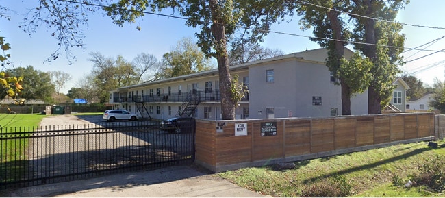
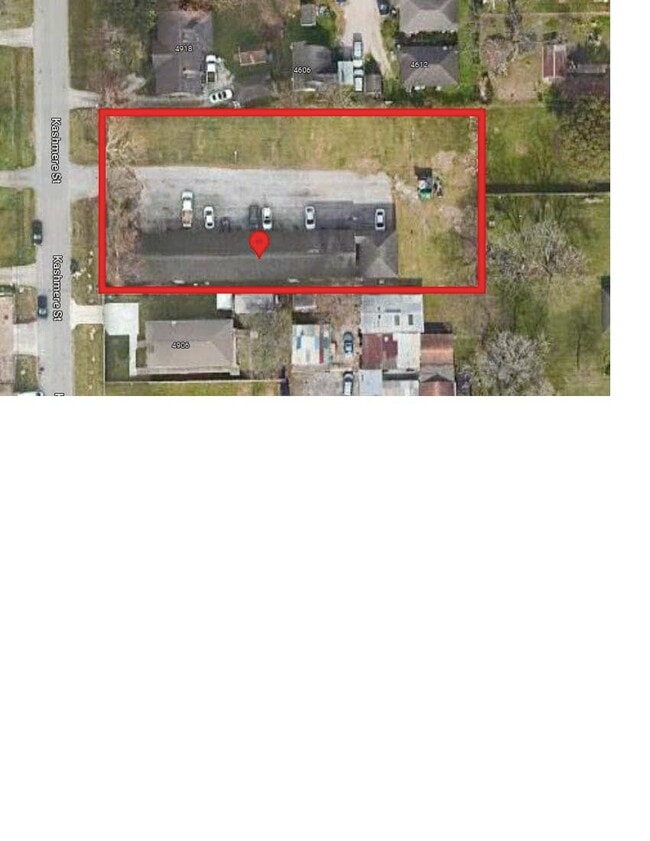
Property Record
4914 Kashmere St, Houston, TX 77026

NEARBY LISTINGS FOR SALE OR LEASE
Property Detail
4914 Kashmere St
Houston-The Woodlands-Sugar Land, TX
Kashmere Gardens
0651220130257
LT 154 BLK 13 KASHMERE GARDENS
Apartment
Harris
AE
Texas
48201C0690N
154
2024
0.34 AC
2025
Kashmere Gardens
211200
Houston
8,724 SF
DEMOGRAPHICS near 4914 Kashmere St
1 Mile
3 Mile
5 Mile
2024 Total Population
12,186
112,838
320,141
2029 Population
12,724
117,010
331,367
Pop Growth 2024-2029
+ 4.41%
+ 3.70%
+ 3.51%
Average Age
39
37
37
2024 Total Households
4,540
39,641
120,825
HH Growth 2024-2029
+ 4.38%
+ 3.78%
+ 3.84%
Median Household Inc
$29,031
$34,813
$49,274
Avg Household Size
2.60
2.80
2.50
2024 Avg HH Vehicles
1.00
2.00
2.00
Median Home Value
$92,966
$137,386
$197,670
Median Year Built
1962
1959
1967
Nearby Places
Map Layers
Map Styles
 Street
 Aerial
- Restaurants
- Banks
- Shops
- Fitness
- Groceries
PUBLIC TRANSPORTATION
COMMUTER RAIL
Houston (Sunset Limited - Amtrak)
DRIVE
WALK
Distance
Houston (Sunset Limited - Amtrak)
11 min
5.6 mi
AIRPORT
George Bush Intcntl/Houston
DRIVE
WALK
Distance
George Bush Intcntl/Houston
23 min
15.4 mi
William P Hobby
DRIVE
WALK
Distance
William P Hobby
29 min
17.1 mi
Freight Ports
Port of Houston
DRIVE
WALK
Distance
Port of Houston
16 min
9.1 mi
SALE & LEASE HISTORY
LISTING DATE
SALE/LEASE

Mar 22, 2023
For Sale
Jun 06, 2023
For Sale
Nearby Properties
Address
Land Use
TOTAL SIZE
Lot Size
Zoning
Address
Land Use
TOTAL SIZE
Lot Size
Zoning
12,206,592 SF
212.18 AC
Address
Land Use
TOTAL SIZE
Lot Size
Zoning
186,808 SF
4.73 AC
Address
Land Use
TOTAL SIZE
Lot Size
Zoning
Address
Land Use
TOTAL SIZE
Lot Size
Zoning
498,726 SF
4.97 AC
Address
Land Use
TOTAL SIZE
Lot Size
Zoning
302,826 SF
2.87 AC
Address
Land Use
TOTAL SIZE
Lot Size
Zoning
224,741 SF
10.75 AC
Address
Land Use
TOTAL SIZE
Lot Size
Zoning
200,902 SF
4.36 AC
Address
Land Use
TOTAL SIZE
Lot Size
Zoning
433,639 SF
19.89 AC
Address
Land Use
TOTAL SIZE
Lot Size
Zoning
789,346 SF
52.49 AC
Address
Land Use
TOTAL SIZE
Lot Size
Zoning
304,925 SF
10.91 AC
Address
Land Use
TOTAL SIZE
Lot Size
Zoning
177,720 SF
14.96 AC
Address
Land Use
TOTAL SIZE
Lot Size
Zoning
306,886 SF
45.06 AC
Address
Land Use
TOTAL SIZE
Lot Size
Zoning
234,016 SF
7.75 AC
Address
Land Use
TOTAL SIZE
Lot Size
Zoning
205,000 SF
9.49 AC
Address
Land Use
TOTAL SIZE
Lot Size
Zoning
189,018 SF
17 AC
Address
Land Use
TOTAL SIZE
Lot Size
Zoning
196,666 SF
9.38 AC
Address
Land Use
TOTAL SIZE
Lot Size
Zoning
89,184 SF
6.89 AC
Address
Land Use
TOTAL SIZE
Lot Size
Zoning
55,517 SF
13 AC
Address
Land Use
TOTAL SIZE
Lot Size
Zoning
241,435 SF
13.47 AC
Address
Land Use
TOTAL SIZE
Lot Size
Zoning
282,621 SF
9.61 AC
Address
Land Use
TOTAL SIZE
Lot Size
Zoning
15,917 SF
15.07 AC
Address
Land Use
TOTAL SIZE
Lot Size
Zoning
108,783 SF
8.83 AC
Address
Land Use
TOTAL SIZE
Lot Size
Zoning
385,950 SF
28.31 AC
Address
Land Use
TOTAL SIZE
Lot Size
Zoning
186,629 SF
9.75 AC
Address
Land Use
TOTAL SIZE
Lot Size
Zoning
212.26 AC
Address
Land Use
TOTAL SIZE
Lot Size
Zoning
246,109 SF
12.79 AC
Address
Land Use
TOTAL SIZE
Lot Size
Zoning
622,385 SF
6.68 AC
Address
Land Use
TOTAL SIZE
Lot Size
Zoning
197,976 SF
24.32 AC
Address
Land Use
TOTAL SIZE
Lot Size
Zoning
67,380 SF
1.81 AC
Address
Land Use
TOTAL SIZE
Lot Size
Zoning
66,452 SF
6 AC
The World's #1 Commercial Real Estate Marketplace
Connect with us
© 2025 CoStar Group
The information above has been obtained from sources believed reliable. While we do not doubt its accuracy we have not verified it and make no guarantee, warranty or representation about it. It is your responsibility to independently confirm its accuracy and completeness. Any projections, opinions, assumptions, or estimates used are for example only and do not represent the current or future performance of the property. The value of this transaction to you depends on tax and other factors which should be evaluated by your tax, financial, and legal advisors. You and your advisors should conduct a careful, independent investigation of the property to determine to your satisfaction the suitability of the property for your needs.