Property Record
4915 Highway 90, Milton, FL 32571
Save to a Folder
{{folder.Name}}
{{folder.ListingIds.length}} Properties
{{folder.ListingIds.length}} Property
Create a New Folder
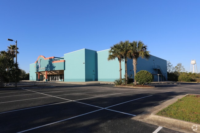
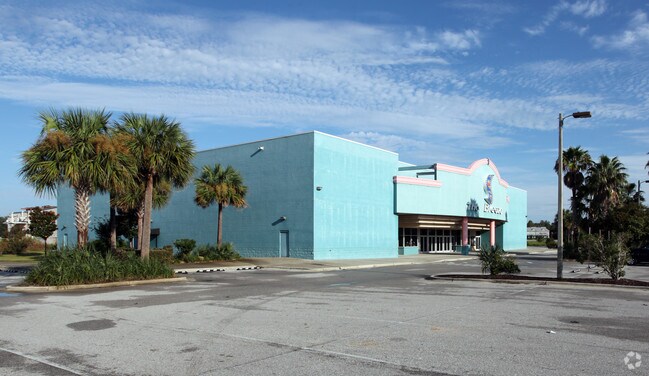
Property Detail
4915 Highway 90
14-1N-29-0000-00201-0000
COMM NE SEC COR TH S 01*43 42 W 49.91 FT TO I/S S R/W HWY 90 TH N 88*2832W 67.70 FT TO I /S W R/W PACE LN TH CONT W 816.37 FT TH S01-07-42W 50 FT TH S88-28-32E 23.41 FT TH S01- 07-42W 135.48 FT TH S46-07-42W 28.31 FT TH N88-52-18W 209 FT TH S01-07-42
Theater
SANTA ROSA
HCD
Florida
B and X Area of moderate flood hazard, usually the area between the limits of the 100-year and 500-year floods.
4.76 AC
2024
Navarre
2025
Pensacola
010704
Pensacola-Ferry Pass-Brent, FL
40,699 SF
NEARBY LISTINGS FOR SALE OR LEASE
DEMOGRAPHICS near 4915 Highway 90
1 mile
3 mile
5 mile
2025 Total Population
6,937
18,058
28,639
2030 Population
7,453
19,649
31,220
Pop Growth 2025-2030
+ 7.44%
+ 8.81%
+ 9.01%
Average Age
43
44
45
2025 Total Households
2,718
7,350
11,832
HH Growth 2025-2030
+ 7.28%
+ 8.90%
+ 9.07%
Median Household Inc
$102,476
$107,034
$112,076
Avg Household Size
2.50
2.40
2.40
2025 Avg HH Vehicles
2.00
2.00
2.00
Median Home Value
$443,107
$452,916
$473,872
Median Year Built
1990
1992
1991
Nearby Places
Map Layers
Map Styles
 Street
 Aerial
Layers
 Traffic
 Biking
Places
Listings with unknown addresses are not visible on the map
- Restaurants
- Banks
- Shops
- Fitness
- Groceries
PUBLIC TRANSPORTATION
AIRPORT
Pensacola International
Drive
Walk
Distance
Pensacola International
29 min
15.2 mi
Nearby Properties
Address
Land Use
TOTAL SIZE
Lot Size
Zoning
Address
Land Use
TOTAL SIZE
Lot Size
Zoning
374,114 SF
27.61 AC
R2
Address
Land Use
TOTAL SIZE
Lot Size
Zoning
118,887 SF
19.24 AC
HCD
Address
Land Use
TOTAL SIZE
Lot Size
Zoning
130,379 SF
18.18 AC
HCD
Address
Land Use
TOTAL SIZE
Lot Size
Zoning
79,708 SF
9.62 AC
HCD
Address
Land Use
TOTAL SIZE
Lot Size
Zoning
232,988 SF
24.57 AC
HCD
Address
Land Use
TOTAL SIZE
Lot Size
Zoning
154,042 SF
10.36 AC
HCD
Address
Land Use
TOTAL SIZE
Lot Size
Zoning
130,603 SF
14.30 AC
R2
Address
Land Use
TOTAL SIZE
Lot Size
Zoning
47.05 AC
AG-RR
Address
Land Use
TOTAL SIZE
Lot Size
Zoning
151,084 SF
19.01 AC
HCD
Address
Land Use
TOTAL SIZE
Lot Size
Zoning
113,652 SF
9.52 AC
C2
Address
Land Use
TOTAL SIZE
Lot Size
Zoning
199,775 SF
8.83 AC
HCD
Address
Land Use
TOTAL SIZE
Lot Size
Zoning
113,899 SF
3.05 AC
HCD
Address
Land Use
TOTAL SIZE
Lot Size
Zoning
76.81 AC
R1
Address
Land Use
TOTAL SIZE
Lot Size
Zoning
81,123 SF
8.78 AC
HCD
Address
Land Use
TOTAL SIZE
Lot Size
Zoning
615,804 SF
16.46 AC
M2
Address
Land Use
TOTAL SIZE
Lot Size
Zoning
60,129 SF
0.11 AC
HCD
Address
Land Use
TOTAL SIZE
Lot Size
Zoning
98,250 SF
49.63 AC
HCD
Address
Land Use
TOTAL SIZE
Lot Size
Zoning
81,150 SF
4.86 AC
HCD
Address
Land Use
TOTAL SIZE
Lot Size
Zoning
13.70 AC
HCD
Address
Land Use
TOTAL SIZE
Lot Size
Zoning
48,210 SF
8.98 AC
C2
Address
Land Use
TOTAL SIZE
Lot Size
Zoning
115,095 SF
7.44 AC
HCD
Address
Land Use
TOTAL SIZE
Lot Size
Zoning
76,674 SF
2.80 AC
HCD
Address
Land Use
TOTAL SIZE
Lot Size
Zoning
43,613 SF
3.44 AC
HCD
Address
Land Use
TOTAL SIZE
Lot Size
Zoning
389.54 AC
AG-RR
Address
Land Use
TOTAL SIZE
Lot Size
Zoning
9.61 AC
R1
Address
Land Use
TOTAL SIZE
Lot Size
Zoning
112,196 SF
343.01 AC
HCD
Address
Land Use
TOTAL SIZE
Lot Size
Zoning
37,820 SF
16.98 AC
HCD
Address
Land Use
TOTAL SIZE
Lot Size
Zoning
50,616 SF
2.56 AC
R3
Address
Land Use
TOTAL SIZE
Lot Size
Zoning
30,564 SF
11.12 AC
HCD
Address
Land Use
TOTAL SIZE
Lot Size
Zoning
51,760 SF
5.50 AC
HCD
The World's #1 Commercial Real Estate Marketplace
Connect with us
© 2026 CoStar Group
The information above has been obtained from sources believed reliable. While we do not doubt its accuracy we have not verified it and make no guarantee, warranty or representation about it. It is your responsibility to independently confirm its accuracy and completeness. Any projections, opinions, assumptions, or estimates used are for example only and do not represent the current or future performance of the property. The value of this transaction to you depends on tax and other factors which should be evaluated by your tax, financial, and legal advisors. You and your advisors should conduct a careful, independent investigation of the property to determine to your satisfaction the suitability of the property for your needs.