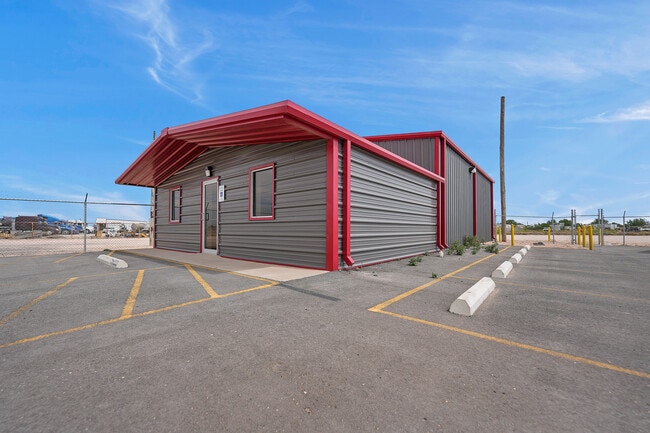
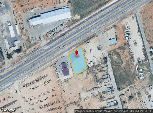
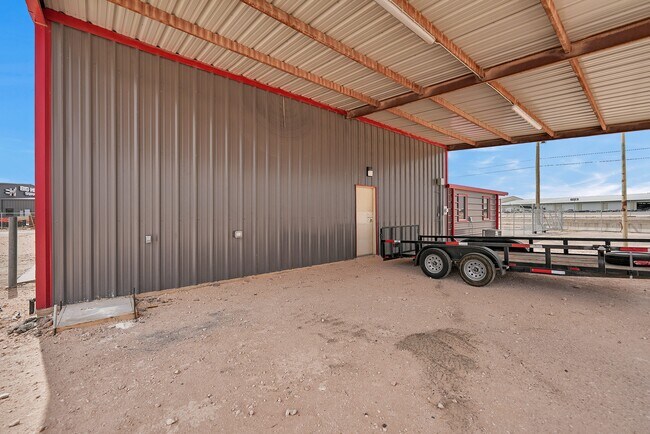
Property Record
W Interstate 20, Midland, TX 79706
NEARBY LISTINGS FOR SALE OR LEASE
Property Detail
W Interstate 20
Other Market Areas
Wakefield
Midland, TX
ACRES: 1.318 BLK: 003 LOT: 001 ADDN: WAKEFIELD SEC 4
R000050-031
Midland
Commercialbuilding
Texas
2025
1
2025
1.32 AC
010127
Midland & Odessa
2,750 SF
DEMOGRAPHICS near W Interstate 20
1 Mile
3 Mile
5 Mile
2024 Total Population
1,721
26,875
84,828
2029 Population
1,687
27,331
86,861
Pop Growth 2024-2029
(1.98%)
+ 1.70%
+ 2.40%
Average Age
31
33
35
2024 Total Households
529
9,085
30,191
HH Growth 2024-2029
(1.70%)
+ 2.09%
+ 2.76%
Median Household Inc
$71,931
$79,292
$77,939
Avg Household Size
3.20
2.90
2.70
2024 Avg HH Vehicles
2.00
2.00
2.00
Median Home Value
$132,353
$204,057
$254,026
Median Year Built
1997
1980
1981
Nearby Places
Map Layers
Map Styles
 Street
 Aerial
- Restaurants
- Banks
- Shops
- Fitness
- Groceries
PUBLIC TRANSPORTATION
AIRPORT
Midland International Air And Space Port
DRIVE
WALK
Distance
Midland International Air And Space Port
18 min
11.2 mi
SALE & LEASE HISTORY
LISTING DATE
SALE/LEASE

May 01, 2023
For Lease
Nearby Properties
Address
Land Use
TOTAL SIZE
Lot Size
Zoning
Address
Land Use
TOTAL SIZE
Lot Size
Zoning
2,453 SF
13.68 AC
Address
Land Use
TOTAL SIZE
Lot Size
Zoning
28,750 SF
10.11 AC
Address
Land Use
TOTAL SIZE
Lot Size
Zoning
Address
Land Use
TOTAL SIZE
Lot Size
Zoning
44,784 SF
11.97 AC
MF1
Address
Land Use
TOTAL SIZE
Lot Size
Zoning
6,864 SF
10.35 AC
Address
Land Use
TOTAL SIZE
Lot Size
Zoning
209,680 SF
6.16 AC
Address
Land Use
TOTAL SIZE
Lot Size
Zoning
1,618 SF
4.18 AC
Address
Land Use
TOTAL SIZE
Lot Size
Zoning
12,420 SF
40.94 AC
Address
Land Use
TOTAL SIZE
Lot Size
Zoning
55,790 SF
2.54 AC
PDSC
Address
Land Use
TOTAL SIZE
Lot Size
Zoning
11,716 SF
1.49 AC
Address
Land Use
TOTAL SIZE
Lot Size
Zoning
3,399 SF
648 AC
Address
Land Use
TOTAL SIZE
Lot Size
Zoning
105,182 SF
5.29 AC
MF1
Address
Land Use
TOTAL SIZE
Lot Size
Zoning
103,600 SF
2.94 AC
Address
Land Use
TOTAL SIZE
Lot Size
Zoning
11,536 SF
1.60 AC
Address
Land Use
TOTAL SIZE
Lot Size
Zoning
70,000 SF
4.42 AC
PDOC
Address
Land Use
TOTAL SIZE
Lot Size
Zoning
31,260 SF
5.83 AC
MF1
Address
Land Use
TOTAL SIZE
Lot Size
Zoning
25,899 SF
13.68 AC
Address
Land Use
TOTAL SIZE
Lot Size
Zoning
300,000 SF
20.01 AC
Address
Land Use
TOTAL SIZE
Lot Size
Zoning
27,025 SF
3.24 AC
Address
Land Use
TOTAL SIZE
Lot Size
Zoning
210,000 SF
8.18 AC
Address
Land Use
TOTAL SIZE
Lot Size
Zoning
17,040 SF
13.55 AC
Address
Land Use
TOTAL SIZE
Lot Size
Zoning
8,331 SF
2.14 AC
LR2
Address
Land Use
TOTAL SIZE
Lot Size
Zoning
11,223 SF
3.70 AC
PDOC
Address
Land Use
TOTAL SIZE
Lot Size
Zoning
303.70 AC
Address
Land Use
TOTAL SIZE
Lot Size
Zoning
35,536 SF
6 AC
Address
Land Use
TOTAL SIZE
Lot Size
Zoning
2,400 SF
6.50 AC
Address
Land Use
TOTAL SIZE
Lot Size
Zoning
4,950 SF
30.75 AC
IP3
Address
Land Use
TOTAL SIZE
Lot Size
Zoning
14,025 SF
17.47 AC
Address
Land Use
TOTAL SIZE
Lot Size
Zoning
19,758 SF
2.76 AC
C3
Address
Land Use
TOTAL SIZE
Lot Size
Zoning
3,892 SF
6 AC
The World's #1 Commercial Real Estate Marketplace
Connect with us
© 2026 CoStar Group
The information above has been obtained from sources believed reliable. While we do not doubt its accuracy we have not verified it and make no guarantee, warranty or representation about it. It is your responsibility to independently confirm its accuracy and completeness. Any projections, opinions, assumptions, or estimates used are for example only and do not represent the current or future performance of the property. The value of this transaction to you depends on tax and other factors which should be evaluated by your tax, financial, and legal advisors. You and your advisors should conduct a careful, independent investigation of the property to determine to your satisfaction the suitability of the property for your needs.