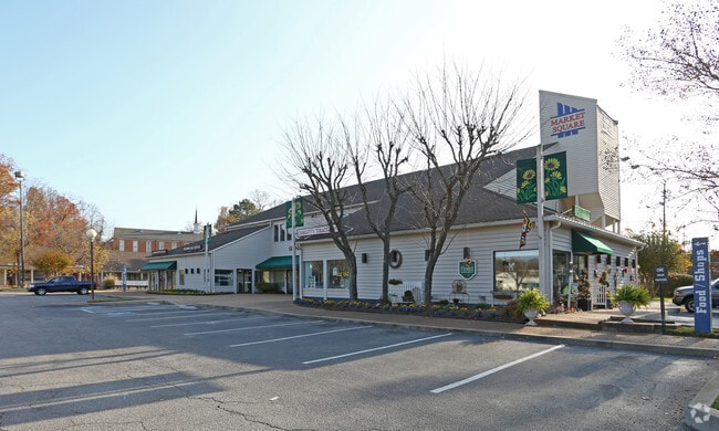
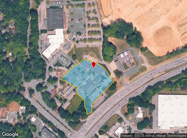
Property Record
4920 Millridge Pky E, Midlothian, VA 23112

NEARBY LISTINGS FOR SALE OR LEASE
Property Detail
4920 Millridge Pky E
Richmond, VA
Village Green Brandermill
733-67-86-14-500-000
VILL GRN BRANDERMILL 000-011
Shoppingcentercommonareaparkingparketc
Chesterfield
X
Virginia
51145C0300C
11
2025
3.25 AC
2025
Rt 288 Corridor
100912
Richmond VA
29,177 SF
DEMOGRAPHICS near 4920 Millridge Pky E
1 Mile
3 Mile
5 Mile
2024 Total Population
6,107
50,378
122,006
2029 Population
6,794
55,070
133,999
Pop Growth 2024-2029
+ 11.25%
+ 9.31%
+ 9.83%
Average Age
40
40
40
2024 Total Households
2,811
19,409
44,661
HH Growth 2024-2029
+ 11.60%
+ 9.51%
+ 9.91%
Median Household Inc
$80,641
$91,260
$104,575
Avg Household Size
2.20
2.60
2.70
2024 Avg HH Vehicles
2.00
2.00
2.00
Median Home Value
$324,090
$305,579
$338,081
Median Year Built
1997
1990
1994
Nearby Places
Map Layers
Map Styles
 Street
 Aerial
- Restaurants
- Banks
- Shops
- Fitness
- Groceries
PUBLIC TRANSPORTATION
AIRPORT
Richmond International
DRIVE
WALK
Distance
Richmond International
40 min
25.3 mi
Freight Ports
Virginia Port Authority - Richmond
DRIVE
WALK
Distance
Virginia Port Authority - Richmond
29 min
14.6 mi
SALE & LEASE HISTORY
LISTING DATE
SALE/LEASE

Sep 25, 2016
For Lease
Aug 03, 2017
For Lease
Nearby Properties
Address
Land Use
TOTAL SIZE
Lot Size
Zoning
Address
Land Use
TOTAL SIZE
Lot Size
Zoning
144,697 SF
97.04 AC
C4 - REGIO
Address
Land Use
TOTAL SIZE
Lot Size
Zoning
101,438 SF
63.19 AC
A - AGRICU
Address
Land Use
TOTAL SIZE
Lot Size
Zoning
137,000 SF
114.67 AC
R9 - SINGL
Address
Land Use
TOTAL SIZE
Lot Size
Zoning
151,510 SF
49.43 AC
R7 - SINGL
Address
Land Use
TOTAL SIZE
Lot Size
Zoning
111,905 SF
29.13 AC
O2 - CORP
Address
Land Use
TOTAL SIZE
Lot Size
Zoning
98,232 SF
24.69 AC
R9 - SINGL
Address
Land Use
TOTAL SIZE
Lot Size
Zoning
105,856 SF
29.30 AC
O2 - CORP
Address
Land Use
TOTAL SIZE
Lot Size
Zoning
11.22 AC
I1 - LT IN
Address
Land Use
TOTAL SIZE
Lot Size
Zoning
111,744 SF
13.26 AC
C3 - COMMU
Address
Land Use
TOTAL SIZE
Lot Size
Zoning
136,718 SF
30.88 AC
RMF - RES,
Address
Land Use
TOTAL SIZE
Lot Size
Zoning
176,592 SF
9.70 AC
RMF - RES,
Address
Land Use
TOTAL SIZE
Lot Size
Zoning
64,809 SF
16.15 AC
O2 - CORP
Address
Land Use
TOTAL SIZE
Lot Size
Zoning
23,256 SF
21.92 AC
C4 - REGIO
Address
Land Use
TOTAL SIZE
Lot Size
Zoning
40,308 SF
27.28 AC
C3 - COMMU
Address
Land Use
TOTAL SIZE
Lot Size
Zoning
220,845 SF
8.36 AC
I1 - LT IN
Address
Land Use
TOTAL SIZE
Lot Size
Zoning
92,840 SF
21.50 AC
A - AGRICU
Address
Land Use
TOTAL SIZE
Lot Size
Zoning
188,736 SF
20.51 AC
C3 - COMMU
Address
Land Use
TOTAL SIZE
Lot Size
Zoning
218,108 SF
20.38 AC
C3 - COMMU
Address
Land Use
TOTAL SIZE
Lot Size
Zoning
62,112 SF
32.90 AC
C3 - COMMU
Address
Land Use
TOTAL SIZE
Lot Size
Zoning
97,740 SF
20.97 AC
R7 - SINGL
Address
Land Use
TOTAL SIZE
Lot Size
Zoning
116,542 SF
38.82 AC
R7 - SINGL
Address
Land Use
TOTAL SIZE
Lot Size
Zoning
54,762 SF
4.82 AC
C4 - REGIO
Address
Land Use
TOTAL SIZE
Lot Size
Zoning
102,180 SF
13.97 AC
C4 - REGIO
Address
Land Use
TOTAL SIZE
Lot Size
Zoning
30,000 SF
11.96 AC
C4 - REGIO
Address
Land Use
TOTAL SIZE
Lot Size
Zoning
10,675 SF
5.83 AC
C3 - COMMU
Address
Land Use
TOTAL SIZE
Lot Size
Zoning
46,989 SF
2.24 AC
C5 - GEN B
Address
Land Use
TOTAL SIZE
Lot Size
Zoning
71,528 SF
23.96 AC
R12 - SING
Address
Land Use
TOTAL SIZE
Lot Size
Zoning
73,969 SF
24.40 AC
R9 - SINGL
Address
Land Use
TOTAL SIZE
Lot Size
Zoning
34,063 SF
4.18 AC
C5 - GEN B
Address
Land Use
TOTAL SIZE
Lot Size
Zoning
6,320 SF
8.25 AC
C3 - COMMU
The World's #1 Commercial Real Estate Marketplace
Connect with us
© 2025 CoStar Group
The information above has been obtained from sources believed reliable. While we do not doubt its accuracy we have not verified it and make no guarantee, warranty or representation about it. It is your responsibility to independently confirm its accuracy and completeness. Any projections, opinions, assumptions, or estimates used are for example only and do not represent the current or future performance of the property. The value of this transaction to you depends on tax and other factors which should be evaluated by your tax, financial, and legal advisors. You and your advisors should conduct a careful, independent investigation of the property to determine to your satisfaction the suitability of the property for your needs.