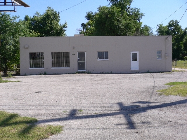
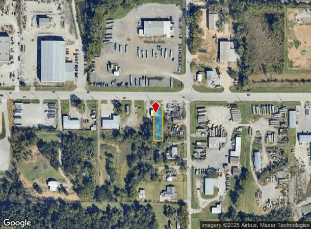
Property Record
4918 W 21St St, Tulsa, OK 74107
Current Lease Availabilities
NEARBY LISTINGS FOR SALE OR LEASE
Property Detail
4918 W 21St St
99217-92-17-03690
Unplatted
Autorepair
BEG 165 W & 50 S NEC NE S 214 W 55 N 214 E 55 TO BEG SEC 17 19 12
X
Tulsa
40113C1245K
Oklahoma
2025
0.27 AC
2025
West Tulsa
006600
Tulsa
2,716 SF
Tulsa, OK
DEMOGRAPHICS near 4918 W 21St St
1 Mile
3 Mile
5 Mile
2024 Total Population
1,579
26,379
93,279
2029 Population
1,659
27,510
97,200
Pop Growth 2024-2029
+ 5.07%
+ 4.29%
+ 4.20%
Average Age
39
39
40
2024 Total Households
607
11,201
40,772
HH Growth 2024-2029
+ 5.27%
+ 4.34%
+ 4.45%
Median Household Inc
$66,940
$45,140
$53,621
Avg Household Size
2.50
2.30
2.20
2024 Avg HH Vehicles
2.00
2.00
2.00
Median Home Value
$79,385
$104,185
$168,328
Median Year Built
1953
1961
1962
Nearby Places
- Restaurants
- Banks
- Shops
- Fitness
- Groceries
PUBLIC TRANSPORTATION
AIRPORT
Tulsa International
DRIVE
WALK
Distance
Tulsa International
21 min
14.6 mi
Freight Ports
Tulsa Port Of Catoosa
DRIVE
WALK
Distance
Tulsa Port Of Catoosa
31 min
23.8 mi
Nearby Properties
Address
Land Use
TOTAL SIZE
Lot Size
Zoning
Address
Land Use
TOTAL SIZE
Lot Size
Zoning
84,560 SF
1.92 AC
CBD
Address
Land Use
TOTAL SIZE
Lot Size
Zoning
137,215 SF
5.08 AC
RM3
Address
Land Use
TOTAL SIZE
Lot Size
Zoning
112,506 SF
2.14 AC
CBD
Address
Land Use
TOTAL SIZE
Lot Size
Zoning
92,076 SF
81.28 AC
IM
Address
Land Use
TOTAL SIZE
Lot Size
Zoning
88,702 SF
8.27 AC
IM
Address
Land Use
TOTAL SIZE
Lot Size
Zoning
21,693 SF
4.24 AC
Address
Land Use
TOTAL SIZE
Lot Size
Zoning
157,736 SF
56.74 AC
RS3
Address
Land Use
TOTAL SIZE
Lot Size
Zoning
106,743 SF
4.34 AC
MX1U55
Address
Land Use
TOTAL SIZE
Lot Size
Zoning
174,776 SF
9.46 AC
RM2
Address
Land Use
TOTAL SIZE
Lot Size
Zoning
89,640 SF
5.47 AC
MX1U55
Address
Land Use
TOTAL SIZE
Lot Size
Zoning
100,857 SF
4.04 AC
MX1U55
Address
Land Use
TOTAL SIZE
Lot Size
Zoning
1,123,266 SF
87.29 AC
IM
Address
Land Use
TOTAL SIZE
Lot Size
Zoning
32,827 SF
4.22 AC
CS
Address
Land Use
TOTAL SIZE
Lot Size
Zoning
102,070 SF
6.92 AC
IM
Address
Land Use
TOTAL SIZE
Lot Size
Zoning
40,003 SF
6.03 AC
IM
Address
Land Use
TOTAL SIZE
Lot Size
Zoning
46,878 SF
4.99 AC
Address
Land Use
TOTAL SIZE
Lot Size
Zoning
6,162 SF
4.25 AC
CH
Address
Land Use
TOTAL SIZE
Lot Size
Zoning
27,225 SF
2.19 AC
MX1U55
Address
Land Use
TOTAL SIZE
Lot Size
Zoning
50,374 SF
1.84 AC
CBD
Address
Land Use
TOTAL SIZE
Lot Size
Zoning
22,078 SF
5.08 AC
CS
Address
Land Use
TOTAL SIZE
Lot Size
Zoning
32,847 SF
28.03 AC
RS3
Address
Land Use
TOTAL SIZE
Lot Size
Zoning
108,279 SF
6.38 AC
AG
Address
Land Use
TOTAL SIZE
Lot Size
Zoning
28,240 SF
147.33 AC
NCU
Address
Land Use
TOTAL SIZE
Lot Size
Zoning
32,722 SF
8.40 AC
RS3
Address
Land Use
TOTAL SIZE
Lot Size
Zoning
17,671 SF
2.54 AC
IM
Address
Land Use
TOTAL SIZE
Lot Size
Zoning
39,992 SF
0.64 AC
CBD
Address
Land Use
TOTAL SIZE
Lot Size
Zoning
253,320 SF
11.91 AC
OM
Address
Land Use
TOTAL SIZE
Lot Size
Zoning
46,452 SF
9.64 AC
CS
The World's #1 Commercial Real Estate Marketplace
Connect with us
© 2025 CoStar Group
The information above has been obtained from sources believed reliable. While we do not doubt its accuracy we have not verified it and make no guarantee, warranty or representation about it. It is your responsibility to independently confirm its accuracy and completeness. Any projections, opinions, assumptions, or estimates used are for example only and do not represent the current or future performance of the property. The value of this transaction to you depends on tax and other factors which should be evaluated by your tax, financial, and legal advisors. You and your advisors should conduct a careful, independent investigation of the property to determine to your satisfaction the suitability of the property for your needs.