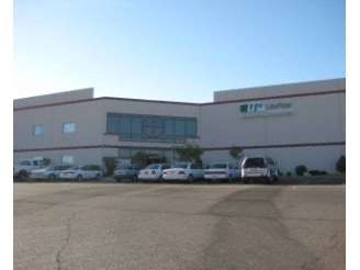
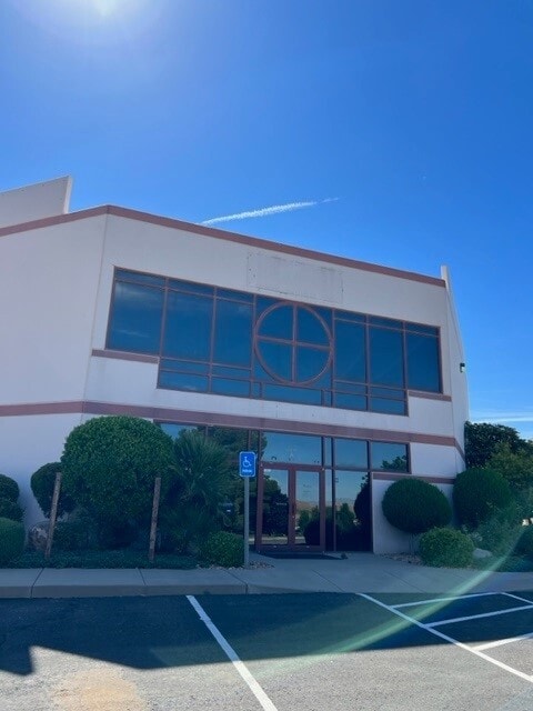
Property Record
492 N Old Highway 91 Hwy, Hurricane, UT 84737

NEARBY LISTINGS FOR SALE OR LEASE
Property Detail
492 N Old Highway 91 Hwy
0615974
S: 34 T: 41S R: 14W BEG S 89*4158 W 883.19 FT ALG SEC/L & S 0*2441 E 542.50 FT FM NE COR SEC 34T41S R14W TH S 0*2441 E 372.50 FT; TH S 59*2548 W 502.50 FT TO W LN SECL/L 1 SEC 34; THN 01*0451 W 550 FT ALG ELY R/W LN HWY91 ALSO BEING ON ARC 800 FT RAD
Commercialnec
Washington
X
Utah
49053C0820G
5.66 AC
2024
Cedar City & St George
2025
Other Market Areas
270904
St. George, UT
26,569 SF
DEMOGRAPHICS near 492 N Old Highway 91 Hwy
1 Mile
3 Mile
5 Mile
2024 Total Population
0
6,330
18,874
2029 Population
0
7,998
23,922
Pop Growth 2024-2029
0.00%
+ 26.35%
+ 26.75%
Average Age
0
44
44
2024 Total Households
0
2,471
7,295
HH Growth 2024-2029
0.00%
+ 26.95%
+ 27.39%
Median Household Inc
$0
$49,840
$56,828
Avg Household Size
.00
2.50
2.50
2024 Avg HH Vehicles
.00
2.00
2.00
Median Home Value
$0
$337,534
$412,930
Median Year Built
0
2005
2008
Nearby Places
Map Layers
Map Styles
 Street
 Aerial
- Restaurants
- Banks
- Shops
- Fitness
- Groceries
PUBLIC TRANSPORTATION
AIRPORT
St George Regional
DRIVE
WALK
Distance
St George Regional
25 min
14.1 mi
SALE & LEASE HISTORY
LISTING DATE
SALE/LEASE

Mar 01, 2018
For Lease
Jan 11, 2024
For Lease
Nearby Properties
Address
Land Use
TOTAL SIZE
Lot Size
Zoning
Address
Land Use
TOTAL SIZE
Lot Size
Zoning
963,552 SF
47.03 AC
PDO
Address
Land Use
TOTAL SIZE
Lot Size
Zoning
1,066,406 SF
210.11 AC
M1
Address
Land Use
TOTAL SIZE
Lot Size
Zoning
112,925 SF
211 AC
OS
Address
Land Use
TOTAL SIZE
Lot Size
Zoning
163,468 SF
19.73 AC
HC
Address
Land Use
TOTAL SIZE
Lot Size
Zoning
81,097 SF
23.10 AC
Address
Land Use
TOTAL SIZE
Lot Size
Zoning
277,666 SF
13.25 AC
PD
Address
Land Use
TOTAL SIZE
Lot Size
Zoning
17,388 SF
41.83 AC
Address
Land Use
TOTAL SIZE
Lot Size
Zoning
199,684 SF
21.48 AC
Address
Land Use
TOTAL SIZE
Lot Size
Zoning
64,047 SF
19.99 AC
M1
Address
Land Use
TOTAL SIZE
Lot Size
Zoning
133,182 SF
11.67 AC
PDO
Address
Land Use
TOTAL SIZE
Lot Size
Zoning
23,235 SF
49.61 AC
A
Address
Land Use
TOTAL SIZE
Lot Size
Zoning
10,820 SF
106 AC
Address
Land Use
TOTAL SIZE
Lot Size
Zoning
63,654 SF
2.54 AC
Address
Land Use
TOTAL SIZE
Lot Size
Zoning
90,302 SF
5.03 AC
PDO
Address
Land Use
TOTAL SIZE
Lot Size
Zoning
11,451 SF
31.90 AC
PDO
Address
Land Use
TOTAL SIZE
Lot Size
Zoning
29,523 SF
13.21 AC
PDO
Address
Land Use
TOTAL SIZE
Lot Size
Zoning
86,000 SF
6.05 AC
BMP
Address
Land Use
TOTAL SIZE
Lot Size
Zoning
112,222 SF
5 AC
PDO
Address
Land Use
TOTAL SIZE
Lot Size
Zoning
40,320 SF
10.67 AC
PDO
Address
Land Use
TOTAL SIZE
Lot Size
Zoning
84,026 SF
3.82 AC
HC
Address
Land Use
TOTAL SIZE
Lot Size
Zoning
79,426 SF
5.65 AC
PDO
Address
Land Use
TOTAL SIZE
Lot Size
Zoning
32,230 SF
14.21 AC
OS
Address
Land Use
TOTAL SIZE
Lot Size
Zoning
77,317 SF
5.01 AC
Address
Land Use
TOTAL SIZE
Lot Size
Zoning
74,444 SF
7.67 AC
PDO
Address
Land Use
TOTAL SIZE
Lot Size
Zoning
72,315 SF
3.95 AC
PDO
Address
Land Use
TOTAL SIZE
Lot Size
Zoning
38,125 SF
4.68 AC
M1
The World's #1 Commercial Real Estate Marketplace
Connect with us
© 2026 CoStar Group
The information above has been obtained from sources believed reliable. While we do not doubt its accuracy we have not verified it and make no guarantee, warranty or representation about it. It is your responsibility to independently confirm its accuracy and completeness. Any projections, opinions, assumptions, or estimates used are for example only and do not represent the current or future performance of the property. The value of this transaction to you depends on tax and other factors which should be evaluated by your tax, financial, and legal advisors. You and your advisors should conduct a careful, independent investigation of the property to determine to your satisfaction the suitability of the property for your needs.