Property Record
492 Highway 35, Eatontown, NJ 07724
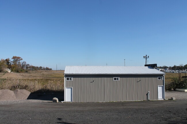
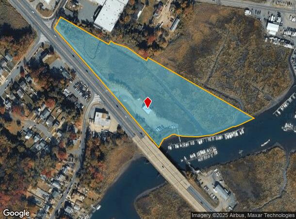
This Property Is For Sale
NEARBY LISTINGS FOR SALE OR LEASE
Property Detail
492 Highway 35
01-00287-0000-00002
ADDITIONAL LOTS: 1 AND 3
Shipyard
Monmouth
AE
New Jersey
34025C0037F
2
2024
3.55 AC
2025
Eastern Monmouth
805100
Northern New Jersey
1,560 SF
New York-Jersey City-White Plains, NY-NJ
DEMOGRAPHICS near 492 Highway 35
1 Mile
3 Mile
5 Mile
2024 Total Population
10,777
67,741
152,519
2029 Population
10,824
67,344
151,520
Pop Growth 2024-2029
+ 0.44%
(0.59%)
(0.66%)
Average Age
41
42
42
2024 Total Households
4,486
25,850
57,558
HH Growth 2024-2029
+ 0.38%
(0.72%)
(0.79%)
Median Household Inc
$90,782
$106,128
$102,766
Avg Household Size
2.30
2.50
2.60
2024 Avg HH Vehicles
2.00
2.00
2.00
Median Home Value
$320,066
$381,911
$404,007
Median Year Built
1966
1967
1970
Nearby Places
- Restaurants
- Banks
- Shops
- Fitness
- Groceries
PUBLIC TRANSPORTATION
COMMUTER RAIL
Aberdeen Matawan (North Jersey Coast Line - NJ Transit Commuter Rail (NJ Transit))
DRIVE
WALK
Distance
Aberdeen Matawan (North Jersey Coast Line - NJ Transit Commuter Rail (NJ Transit))
4 min
2.3 mi
Hazlet (North Jersey Coast Line - NJ Transit Commuter Rail (NJ Transit))
DRIVE
WALK
Distance
Hazlet (North Jersey Coast Line - NJ Transit Commuter Rail (NJ Transit))
4 min
3.0 mi
AIRPORT
Newark Liberty International
DRIVE
WALK
Distance
Newark Liberty International
37 min
26.6 mi
LaGuardia
DRIVE
WALK
Distance
LaGuardia
66 min
44.0 mi
John F Kennedy International
DRIVE
WALK
Distance
John F Kennedy International
68 min
47.1 mi
Freight Ports
New York Container Terminal
DRIVE
WALK
Distance
New York Container Terminal
30 min
21.7 mi
Nearby Properties
Address
Land Use
TOTAL SIZE
Lot Size
Zoning
Address
Land Use
TOTAL SIZE
Lot Size
Zoning
Address
Land Use
TOTAL SIZE
Lot Size
Zoning
157,615 SF
17.08 AC
M
Address
Land Use
TOTAL SIZE
Lot Size
Zoning
70,624 SF
1.56 AC
WD
Address
Land Use
TOTAL SIZE
Lot Size
Zoning
3.98 AC
MUD
Address
Land Use
TOTAL SIZE
Lot Size
Zoning
2.70 AC
LI
Address
Land Use
TOTAL SIZE
Lot Size
Zoning
192,538 SF
45.11 AC
R100
Address
Land Use
TOTAL SIZE
Lot Size
Zoning
10.58 AC
APTH
Address
Land Use
TOTAL SIZE
Lot Size
Zoning
39,965 SF
17.14 AC
BH
Address
Land Use
TOTAL SIZE
Lot Size
Zoning
4.23 AC
LI
Address
Land Use
TOTAL SIZE
Lot Size
Zoning
186,567 SF
2.31 AC
RC
Address
Land Use
TOTAL SIZE
Lot Size
Zoning
94,150 SF
13.62 AC
M
Address
Land Use
TOTAL SIZE
Lot Size
Zoning
70,854 SF
14.30 AC
MF0
Address
Land Use
TOTAL SIZE
Lot Size
Zoning
196,948 SF
19.80 AC
BH
Address
Land Use
TOTAL SIZE
Lot Size
Zoning
9.12 AC
APTH
Address
Land Use
TOTAL SIZE
Lot Size
Zoning
81.64 AC
R70
Address
Land Use
TOTAL SIZE
Lot Size
Zoning
420 SF
87.76 AC
OL2
Address
Land Use
TOTAL SIZE
Lot Size
Zoning
8.99 AC
MF0
Address
Land Use
TOTAL SIZE
Lot Size
Zoning
8.62 AC
RC
Address
Land Use
TOTAL SIZE
Lot Size
Zoning
6 AC
RC
Address
Land Use
TOTAL SIZE
Lot Size
Zoning
109,643 SF
1.87 AC
SB
Address
Land Use
TOTAL SIZE
Lot Size
Zoning
287,915 SF
31.10 AC
I
Address
Land Use
TOTAL SIZE
Lot Size
Zoning
162,250 SF
2.80 AC
RC
Address
Land Use
TOTAL SIZE
Lot Size
Zoning
85,752 SF
8.92 AC
Address
Land Use
TOTAL SIZE
Lot Size
Zoning
6.80 AC
RM
Address
Land Use
TOTAL SIZE
Lot Size
Zoning
124,651 SF
25.02 AC
CD
Address
Land Use
TOTAL SIZE
Lot Size
Zoning
142,360 SF
16.50 AC
BH
Address
Land Use
TOTAL SIZE
Lot Size
Zoning
42,681 SF
10.34 AC
P
Address
Land Use
TOTAL SIZE
Lot Size
Zoning
91,171 SF
25.94 AC
PC
Address
Land Use
TOTAL SIZE
Lot Size
Zoning
4,878 SF
24.90 AC
M-2
Address
Land Use
TOTAL SIZE
Lot Size
Zoning
104,250 SF
18.75 AC
BH
The World's #1 Commercial Real Estate Marketplace
Connect with us
© 2025 CoStar Group
The information above has been obtained from sources believed reliable. While we do not doubt its accuracy we have not verified it and make no guarantee, warranty or representation about it. It is your responsibility to independently confirm its accuracy and completeness. Any projections, opinions, assumptions, or estimates used are for example only and do not represent the current or future performance of the property. The value of this transaction to you depends on tax and other factors which should be evaluated by your tax, financial, and legal advisors. You and your advisors should conduct a careful, independent investigation of the property to determine to your satisfaction the suitability of the property for your needs.