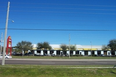
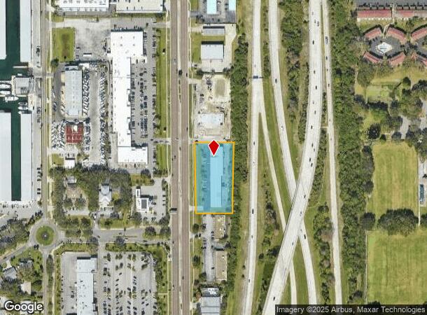
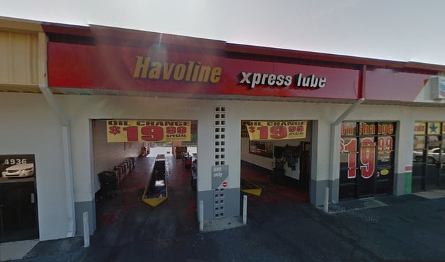
Property Record
4920 34Th St S, Saint Petersburg, FL 33711

NEARBY LISTINGS FOR SALE OR LEASE
Property Detail
4920 34Th St S
Tampa-St. Petersburg-Clearwater, FL
Maximo Moorings I-275
02-32-16-56156-001-0010
MAXIMO MOORINGS I-275 FIRST ADDITION BLK 1, LOT 1
Autorepair
Pinellas
AE
Florida
12103C0281H
1
2024
1.49 AC
2025
South Pinellas
020105
Tampa/St Petersburg
17,650 SF
DEMOGRAPHICS near 4920 34Th St S
1 Mile
3 Mile
5 Mile
2024 Total Population
12,240
76,143
168,102
2029 Population
12,457
77,278
170,288
Pop Growth 2024-2029
+ 1.77%
+ 1.49%
+ 1.30%
Average Age
45
45
46
2024 Total Households
5,080
33,223
80,335
HH Growth 2024-2029
+ 1.89%
+ 1.63%
+ 1.31%
Median Household Inc
$71,214
$61,234
$65,686
Avg Household Size
2.00
2.10
2.00
2024 Avg HH Vehicles
2.00
2.00
1.00
Median Home Value
$416,486
$301,053
$342,936
Median Year Built
1978
1971
1969
Nearby Places
Map Layers
Map Styles
 Street
 Aerial
- Restaurants
- Banks
- Shops
- Fitness
- Groceries
PUBLIC TRANSPORTATION
AIRPORT
St Pete-Clearwater International
DRIVE
WALK
Distance
St Pete-Clearwater International
28 min
16.7 mi
Tampa International
DRIVE
WALK
Distance
Tampa International
35 min
25.4 mi
Sarasota/Bradenton International
DRIVE
WALK
Distance
Sarasota/Bradenton International
41 min
27.7 mi
Freight Ports
Port Manatee
DRIVE
WALK
Distance
Port Manatee
28 min
20.3 mi
SALE & LEASE HISTORY
LISTING DATE
SALE/LEASE

Sep 23, 2016
For Sale
May 24, 2017
For Lease
Jul 22, 2017
For Lease
Nearby Properties
Address
Land Use
TOTAL SIZE
Lot Size
Zoning
Address
Land Use
TOTAL SIZE
Lot Size
Zoning
473,962 SF
174.53 AC
Address
Land Use
TOTAL SIZE
Lot Size
Zoning
850,770 SF
92.67 AC
Address
Land Use
TOTAL SIZE
Lot Size
Zoning
386,795 SF
10.98 AC
Address
Land Use
TOTAL SIZE
Lot Size
Zoning
402,572 SF
10.02 AC
Address
Land Use
TOTAL SIZE
Lot Size
Zoning
512,449 SF
6.01 AC
Address
Land Use
TOTAL SIZE
Lot Size
Zoning
431,739 SF
3.29 AC
Address
Land Use
TOTAL SIZE
Lot Size
Zoning
568,794 SF
23.72 AC
Address
Land Use
TOTAL SIZE
Lot Size
Zoning
341,472 SF
29.42 AC
Address
Land Use
TOTAL SIZE
Lot Size
Zoning
569,924 SF
32.97 AC
Address
Land Use
TOTAL SIZE
Lot Size
Zoning
338,850 SF
17.86 AC
Address
Land Use
TOTAL SIZE
Lot Size
Zoning
395,221 SF
16.78 AC
Address
Land Use
TOTAL SIZE
Lot Size
Zoning
381,519 SF
21.10 AC
Address
Land Use
TOTAL SIZE
Lot Size
Zoning
363,844 SF
23.74 AC
Address
Land Use
TOTAL SIZE
Lot Size
Zoning
283,123 SF
14.22 AC
Address
Land Use
TOTAL SIZE
Lot Size
Zoning
387,624 SF
18.53 AC
Address
Land Use
TOTAL SIZE
Lot Size
Zoning
1,600 SF
191.80 AC
Address
Land Use
TOTAL SIZE
Lot Size
Zoning
183,954 SF
38.36 AC
Address
Land Use
TOTAL SIZE
Lot Size
Zoning
232,380 SF
36.82 AC
Address
Land Use
TOTAL SIZE
Lot Size
Zoning
146,000 SF
21.14 AC
Address
Land Use
TOTAL SIZE
Lot Size
Zoning
223,180 SF
11.79 AC
Address
Land Use
TOTAL SIZE
Lot Size
Zoning
225,801 SF
20.59 AC
Address
Land Use
TOTAL SIZE
Lot Size
Zoning
171,919 SF
29.67 AC
Address
Land Use
TOTAL SIZE
Lot Size
Zoning
138,748 SF
10.92 AC
Address
Land Use
TOTAL SIZE
Lot Size
Zoning
107,257 SF
10.29 AC
Address
Land Use
TOTAL SIZE
Lot Size
Zoning
273,939 SF
16.18 AC
Address
Land Use
TOTAL SIZE
Lot Size
Zoning
193,096 SF
5.28 AC
Address
Land Use
TOTAL SIZE
Lot Size
Zoning
95,824 SF
13.87 AC
Address
Land Use
TOTAL SIZE
Lot Size
Zoning
72,149 SF
13.39 AC
Address
Land Use
TOTAL SIZE
Lot Size
Zoning
29,587 SF
40.27 AC
Address
Land Use
TOTAL SIZE
Lot Size
Zoning
72,149 SF
11.71 AC
The World's #1 Commercial Real Estate Marketplace
Connect with us
© 2025 CoStar Group
The information above has been obtained from sources believed reliable. While we do not doubt its accuracy we have not verified it and make no guarantee, warranty or representation about it. It is your responsibility to independently confirm its accuracy and completeness. Any projections, opinions, assumptions, or estimates used are for example only and do not represent the current or future performance of the property. The value of this transaction to you depends on tax and other factors which should be evaluated by your tax, financial, and legal advisors. You and your advisors should conduct a careful, independent investigation of the property to determine to your satisfaction the suitability of the property for your needs.