Property Record
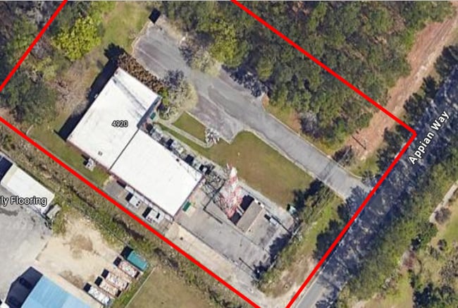
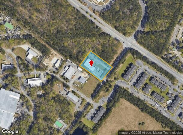
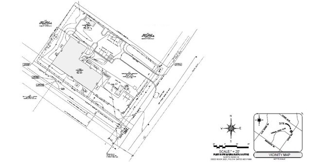
4920 Appian Way, North Charleston, SC 29420
NEARBY LISTINGS FOR SALE OR LEASE
Property Detail
4920 Appian Way
172-00-00-080
A Boundary Plat Of A 12000 Square Foot T
Governmentalpublicusegeneral
ALSO J-118
X
Dorchester
45019C0290K
South Carolina
2025
1.37 AC
2025
Dorchester County
010818
Charleston/N Charleston
4,019 SF
Charleston-North Charleston, SC
DEMOGRAPHICS near 4920 Appian Way
1 Mile
3 Mile
5 Mile
2024 Total Population
8,810
48,275
112,416
2029 Population
9,469
51,944
120,665
Pop Growth 2024-2029
+ 7.48%
+ 7.60%
+ 7.34%
Average Age
37
37
36
2024 Total Households
3,157
18,347
43,989
HH Growth 2024-2029
+ 7.22%
+ 7.47%
+ 7.18%
Median Household Inc
$63,133
$75,646
$62,057
Avg Household Size
2.70
2.60
2.50
2024 Avg HH Vehicles
2.00
2.00
2.00
Median Home Value
$274,279
$273,057
$241,962
Median Year Built
1997
2000
1999
Nearby Places
Map Layers
Map Styles
 Street
 Aerial
- Restaurants
- Banks
- Shops
- Fitness
- Groceries
PUBLIC TRANSPORTATION
AIRPORT
Charleston AFB/International
DRIVE
WALK
Distance
Charleston AFB/International
8 min
5.1 mi
Freight Ports
North Charleston Terminal
DRIVE
WALK
Distance
North Charleston Terminal
16 min
9.5 mi
SALE & LEASE HISTORY
LISTING DATE
SALE/LEASE

Sep 24, 2016
For Sale
May 14, 2019
For Lease
Mar 18, 2025
For Lease
Nearby Properties
Address
Land Use
TOTAL SIZE
Lot Size
Zoning
Address
Land Use
TOTAL SIZE
Lot Size
Zoning
48.89 AC
Address
Land Use
TOTAL SIZE
Lot Size
Zoning
1,430 SF
28.27 AC
Address
Land Use
TOTAL SIZE
Lot Size
Zoning
Address
Land Use
TOTAL SIZE
Lot Size
Zoning
14.75 AC
Address
Land Use
TOTAL SIZE
Lot Size
Zoning
16.40 AC
Address
Land Use
TOTAL SIZE
Lot Size
Zoning
417.51 AC
AC_SV
Address
Land Use
TOTAL SIZE
Lot Size
Zoning
1,272 SF
18.46 AC
Address
Land Use
TOTAL SIZE
Lot Size
Zoning
33.62 AC
Address
Land Use
TOTAL SIZE
Lot Size
Zoning
14.33 AC
Address
Land Use
TOTAL SIZE
Lot Size
Zoning
199,300 SF
13.28 AC
Address
Land Use
TOTAL SIZE
Lot Size
Zoning
126,385 SF
13.45 AC
Address
Land Use
TOTAL SIZE
Lot Size
Zoning
48,400 SF
5.76 AC
Address
Land Use
TOTAL SIZE
Lot Size
Zoning
44,300 SF
2.34 AC
Address
Land Use
TOTAL SIZE
Lot Size
Zoning
Address
Land Use
TOTAL SIZE
Lot Size
Zoning
1,286 SF
20 AC
R-2_NC
Address
Land Use
TOTAL SIZE
Lot Size
Zoning
332,013 SF
74.26 AC
R-3_NC
Address
Land Use
TOTAL SIZE
Lot Size
Zoning
384,000 SF
23.95 AC
PDD_NC
Address
Land Use
TOTAL SIZE
Lot Size
Zoning
5,125 SF
15.99 AC
R-2_NC
Address
Land Use
TOTAL SIZE
Lot Size
Zoning
9,241 SF
9.66 AC
PDD_NC
Address
Land Use
TOTAL SIZE
Lot Size
Zoning
339,744 SF
17.75 AC
R-1_NC
Address
Land Use
TOTAL SIZE
Lot Size
Zoning
Address
Land Use
TOTAL SIZE
Lot Size
Zoning
102,297 SF
20.14 AC
PDD_NC
Address
Land Use
TOTAL SIZE
Lot Size
Zoning
189,648 SF
40.49 AC
R-1_NC
Address
Land Use
TOTAL SIZE
Lot Size
Zoning
185,000 SF
28.36 AC
R-2_NC
Address
Land Use
TOTAL SIZE
Lot Size
Zoning
99.87 AC
Address
Land Use
TOTAL SIZE
Lot Size
Zoning
Address
Land Use
TOTAL SIZE
Lot Size
Zoning
194,994 SF
21.28 AC
R-4_DC
Address
Land Use
TOTAL SIZE
Lot Size
Zoning
256,996 SF
22.18 AC
R-2_NC
Address
Land Use
TOTAL SIZE
Lot Size
Zoning
256,996 SF
29.96 AC
PDD_NC
Address
Land Use
TOTAL SIZE
Lot Size
Zoning
1,842 SF
17.11 AC
The World's #1 Commercial Real Estate Marketplace
Connect with us
© 2025 CoStar Group
The information above has been obtained from sources believed reliable. While we do not doubt its accuracy we have not verified it and make no guarantee, warranty or representation about it. It is your responsibility to independently confirm its accuracy and completeness. Any projections, opinions, assumptions, or estimates used are for example only and do not represent the current or future performance of the property. The value of this transaction to you depends on tax and other factors which should be evaluated by your tax, financial, and legal advisors. You and your advisors should conduct a careful, independent investigation of the property to determine to your satisfaction the suitability of the property for your needs.