Property Record
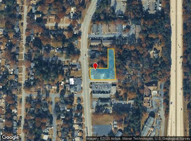
4920 Armour Rd, Columbus, GA 31904

NEARBY LISTINGS FOR SALE OR LEASE
Property Detail
4920 Armour Rd
Columbus, GA-AL
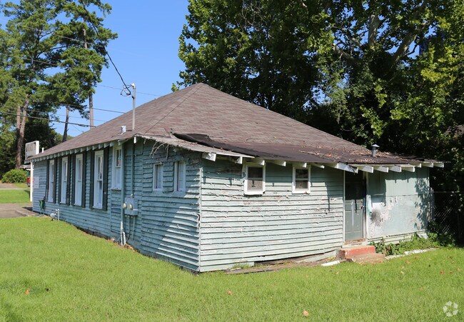
House On Commercial Property
069-002-004
PAR 234 SUR FOR REP PT LOTS 2 3 & 4 PROP THOMAS L BROCK
Commercialnec
Muscogee
X
Georgia
01113C0075C
2-4
2025
1.08 AC
2025
Greater Columbus
000200
Columbus GA
1,484 SF
DEMOGRAPHICS near 4920 Armour Rd
1 Mile
3 Mile
5 Mile
2024 Total Population
5,401
63,330
165,403
2029 Population
5,271
62,016
162,516
Pop Growth 2024-2029
(2.41%)
(2.07%)
(1.75%)
Average Age
38
38
38
2024 Total Households
2,317
26,190
68,528
HH Growth 2024-2029
(2.55%)
(2.20%)
(1.81%)
Median Household Inc
$49,776
$52,022
$50,866
Avg Household Size
2.20
2.30
2.30
2024 Avg HH Vehicles
1.00
2.00
2.00
Median Home Value
$149,561
$170,328
$167,558
Median Year Built
1970
1969
1976
Nearby Places
Map Layers
Map Styles
 Street
 Aerial
- Restaurants
- Banks
- Shops
- Fitness
- Groceries
PUBLIC TRANSPORTATION
AIRPORT
Columbus
DRIVE
WALK
Distance
Columbus
4 min
1.4 mi
Freight Ports
Port of Panama City
DRIVE
WALK
Distance
Port of Panama City
239 min
188.1 mi
Nearby Properties
Address
Land Use
TOTAL SIZE
Lot Size
Zoning
Address
Land Use
TOTAL SIZE
Lot Size
Zoning
81,423 SF
11.54 AC
Address
Land Use
TOTAL SIZE
Lot Size
Zoning
2,744 SF
41.16 AC
Address
Land Use
TOTAL SIZE
Lot Size
Zoning
304,921 SF
75.14 AC
Address
Land Use
TOTAL SIZE
Lot Size
Zoning
174,892 SF
19.03 AC
Address
Land Use
TOTAL SIZE
Lot Size
Zoning
11,230 SF
25.05 AC
Address
Land Use
TOTAL SIZE
Lot Size
Zoning
15,330 SF
33.84 AC
Address
Land Use
TOTAL SIZE
Lot Size
Zoning
55,900 SF
27.05 AC
Address
Land Use
TOTAL SIZE
Lot Size
Zoning
9,266 SF
50.07 AC
Address
Land Use
TOTAL SIZE
Lot Size
Zoning
8,620 SF
25.15 AC
Address
Land Use
TOTAL SIZE
Lot Size
Zoning
71,337 SF
17.24 AC
Address
Land Use
TOTAL SIZE
Lot Size
Zoning
216,360 SF
17.51 AC
Address
Land Use
TOTAL SIZE
Lot Size
Zoning
14,253 SF
6.71 AC
Address
Land Use
TOTAL SIZE
Lot Size
Zoning
63,220 SF
3.49 AC
Address
Land Use
TOTAL SIZE
Lot Size
Zoning
37,202 SF
8.03 AC
Address
Land Use
TOTAL SIZE
Lot Size
Zoning
10,683 SF
588.24 AC
Address
Land Use
TOTAL SIZE
Lot Size
Zoning
176,877 SF
26.35 AC
Address
Land Use
TOTAL SIZE
Lot Size
Zoning
4,360 SF
25.18 AC
Address
Land Use
TOTAL SIZE
Lot Size
Zoning
Address
Land Use
TOTAL SIZE
Lot Size
Zoning
Address
Land Use
TOTAL SIZE
Lot Size
Zoning
4,187 SF
12.56 AC
Address
Land Use
TOTAL SIZE
Lot Size
Zoning
47,849 SF
22.26 AC
Address
Land Use
TOTAL SIZE
Lot Size
Zoning
6,254 SF
13.04 AC
Address
Land Use
TOTAL SIZE
Lot Size
Zoning
Address
Land Use
TOTAL SIZE
Lot Size
Zoning
142,703 SF
28.48 AC
Address
Land Use
TOTAL SIZE
Lot Size
Zoning
Address
Land Use
TOTAL SIZE
Lot Size
Zoning
1,699 SF
25.80 AC
Address
Land Use
TOTAL SIZE
Lot Size
Zoning
45,932 SF
29 AC
Address
Land Use
TOTAL SIZE
Lot Size
Zoning
310,607 SF
36.08 AC
Address
Land Use
TOTAL SIZE
Lot Size
Zoning
150,424 SF
22.95 AC
Address
Land Use
TOTAL SIZE
Lot Size
Zoning
78,948 SF
6 AC
The World's #1 Commercial Real Estate Marketplace
Connect with us
© 2025 CoStar Group
The information above has been obtained from sources believed reliable. While we do not doubt its accuracy we have not verified it and make no guarantee, warranty or representation about it. It is your responsibility to independently confirm its accuracy and completeness. Any projections, opinions, assumptions, or estimates used are for example only and do not represent the current or future performance of the property. The value of this transaction to you depends on tax and other factors which should be evaluated by your tax, financial, and legal advisors. You and your advisors should conduct a careful, independent investigation of the property to determine to your satisfaction the suitability of the property for your needs.