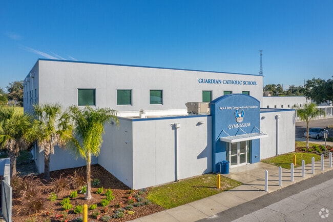
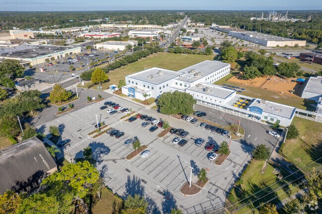
Property Record
4920 Brentwood Ave, Jacksonville, FL 32206

NEARBY LISTINGS FOR SALE OR LEASE
Property Detail
4920 Brentwood Ave
087672-0000
Brentwood
Religious
12-073 39-1S-26E BRENTWOOD PT SEC 39-1S-26E & PT BLKS 2,3,9, 10,18 & PT CLOSED STS RECD D BK 1662-9(EX PT IN ST RECD O/R BK 104-371 & PT RECD O/R BKS 2586-1041, 3412-915,3437-648)
X
Duval
12031C0356H
Florida
0
9.81 AC
2026
Downtown Northbank
001402
Jacksonville (Florida)
70,832 SF
Jacksonville, FL
DEMOGRAPHICS near 4920 Brentwood Ave
1 Mile
3 Mile
5 Mile
2024 Total Population
12,362
85,743
197,049
2029 Population
13,060
91,201
208,449
Pop Growth 2024-2029
+ 5.65%
+ 6.37%
+ 5.79%
Average Age
38
39
39
2024 Total Households
5,101
33,835
80,177
HH Growth 2024-2029
+ 5.65%
+ 6.67%
+ 6.06%
Median Household Inc
$28,203
$29,825
$37,889
Avg Household Size
2.40
2.30
2.30
2024 Avg HH Vehicles
1.00
1.00
1.00
Median Home Value
$99,070
$100,834
$148,964
Median Year Built
1956
1961
1964
Nearby Places
Map Layers
Map Styles
 Street
 Aerial
- Restaurants
- Banks
- Shops
- Fitness
- Groceries
PUBLIC TRANSPORTATION
COMMUTER RAIL
Jacksonville (Silver Meteor - Amtrak, Silver Star - Amtrak)
DRIVE
WALK
Distance
Jacksonville (Silver Meteor - Amtrak, Silver Star - Amtrak)
10 min
4.9 mi
AIRPORT
Jacksonville International
DRIVE
WALK
Distance
Jacksonville International
19 min
11.6 mi
Freight Ports
Jacksonville Port
DRIVE
WALK
Distance
Jacksonville Port
8 min
3.2 mi
Nearby Properties
Address
Land Use
TOTAL SIZE
Lot Size
Zoning
Address
Land Use
TOTAL SIZE
Lot Size
Zoning
543,383 SF
7.87 AC
CCBD
Address
Land Use
TOTAL SIZE
Lot Size
Zoning
705,940 SF
25.12 AC
PBF-1
Address
Land Use
TOTAL SIZE
Lot Size
Zoning
127,732 SF
1.44 AC
CCBD
Address
Land Use
TOTAL SIZE
Lot Size
Zoning
313,472 SF
35.44 AC
CCBD
Address
Land Use
TOTAL SIZE
Lot Size
Zoning
503,858 SF
1.32 AC
CCBD
Address
Land Use
TOTAL SIZE
Lot Size
Zoning
326,485 SF
1.56 AC
CCBD
Address
Land Use
TOTAL SIZE
Lot Size
Zoning
329,412 SF
1.75 AC
CCBD
Address
Land Use
TOTAL SIZE
Lot Size
Zoning
229,284 SF
7.24 AC
PUD
Address
Land Use
TOTAL SIZE
Lot Size
Zoning
165,035 SF
1.52 AC
CCBD
Address
Land Use
TOTAL SIZE
Lot Size
Zoning
163,471 SF
7.85 AC
PBF-2
Address
Land Use
TOTAL SIZE
Lot Size
Zoning
23,689 SF
19.97 AC
CCBD
Address
Land Use
TOTAL SIZE
Lot Size
Zoning
271,336 SF
1.25 AC
CCBD
Address
Land Use
TOTAL SIZE
Lot Size
Zoning
313,741 SF
37.05 AC
RMD-C
Address
Land Use
TOTAL SIZE
Lot Size
Zoning
276,156 SF
2.41 AC
CCG-S
Address
Land Use
TOTAL SIZE
Lot Size
Zoning
144,400 SF
10.32 AC
PBF-2
Address
Land Use
TOTAL SIZE
Lot Size
Zoning
311,068 SF
18.91 AC
PBF-1
Address
Land Use
TOTAL SIZE
Lot Size
Zoning
274,834 SF
17.84 AC
IW
Address
Land Use
TOTAL SIZE
Lot Size
Zoning
275,550 SF
1.84 AC
CCBD
Address
Land Use
TOTAL SIZE
Lot Size
Zoning
188,970 SF
1.55 AC
CCBD
Address
Land Use
TOTAL SIZE
Lot Size
Zoning
77,356 SF
2.15 AC
PBF-2
Address
Land Use
TOTAL SIZE
Lot Size
Zoning
186,773 SF
9.77 AC
CCG-2
Address
Land Use
TOTAL SIZE
Lot Size
Zoning
119,362 SF
20.32 AC
RMD-C
Address
Land Use
TOTAL SIZE
Lot Size
Zoning
40,984 SF
2.33 AC
CCBD
Address
Land Use
TOTAL SIZE
Lot Size
Zoning
604,760 SF
11.06 AC
IW
Address
Land Use
TOTAL SIZE
Lot Size
Zoning
115,387 SF
0.24 AC
CCBD
Address
Land Use
TOTAL SIZE
Lot Size
Zoning
216,278 SF
0.73 AC
CCBD
Address
Land Use
TOTAL SIZE
Lot Size
Zoning
276,782 SF
50.66 AC
IW
Address
Land Use
TOTAL SIZE
Lot Size
Zoning
258,700 SF
25.43 AC
RMD-D
Address
Land Use
TOTAL SIZE
Lot Size
Zoning
679,901 SF
18.30 AC
PBF-1
Address
Land Use
TOTAL SIZE
Lot Size
Zoning
72,192 SF
1.65 AC
CCBD
The World's #1 Commercial Real Estate Marketplace
Connect with us
© 2026 CoStar Group
The information above has been obtained from sources believed reliable. While we do not doubt its accuracy we have not verified it and make no guarantee, warranty or representation about it. It is your responsibility to independently confirm its accuracy and completeness. Any projections, opinions, assumptions, or estimates used are for example only and do not represent the current or future performance of the property. The value of this transaction to you depends on tax and other factors which should be evaluated by your tax, financial, and legal advisors. You and your advisors should conduct a careful, independent investigation of the property to determine to your satisfaction the suitability of the property for your needs.