Property Record
4920 E Parsons Point Rd, Hernando, FL 34442


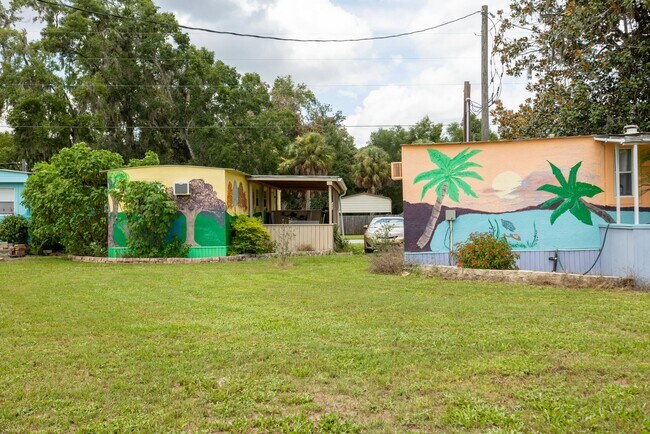
This Property Is For Sale
Property Detail
4920 E Parsons Point Rd
19E-18S-24-0010-00060-0270
PARSONS PT ADD TO HERNANDO PB 2 PG 19 LOTS 27 28 29 30 31 32 33 34 & 35 BLK 6
Parkinglot
Citrus
CLRMH
Florida
B and X Area of moderate flood hazard, usually the area between the limits of the 100-year and 500-year floods.
27
2025
1.35 AC
2025
Florida Central North Area
450800
Other Market Areas
4,800 SF
Homosassa Springs, FL
NEARBY LISTINGS FOR SALE OR LEASE
-
-
View all Hernando listings for sale on LoopNet.com
DEMOGRAPHICS near 4920 E Parsons Point Rd
1 mile
3 mile
5 mile
2025 Total Population
906
8,915
29,608
2030 Population
997
9,782
32,399
Pop Growth 2025-2030
+ 10.04%
+ 9.73%
+ 9.43%
Average Age
52
50
50
2025 Total Households
457
4,137
13,667
HH Growth 2025-2030
+ 10.07%
+ 9.91%
+ 9.63%
Median Household Inc
$21,041
$48,818
$52,857
Avg Household Size
2.00
2.10
2.10
2025 Avg HH Vehicles
2.00
2.00
2.00
Median Home Value
$161,818
$246,614
$279,817
Median Year Built
1977
1990
1990
Nearby Places
Map Layers
Map Styles
 Street
 Aerial
Layers
 Traffic
 Biking
Places
Listings with unknown addresses are not visible on the map
- Restaurants
- Banks
- Shops
- Fitness
- Groceries
Nearby Properties
Address
Land Use
TOTAL SIZE
Lot Size
Zoning
Address
Land Use
TOTAL SIZE
Lot Size
Zoning
84,611 SF
33.22 AC
PSI
Address
Land Use
TOTAL SIZE
Lot Size
Zoning
119,399 SF
4.77 AC
GNC
Address
Land Use
TOTAL SIZE
Lot Size
Zoning
74,320 SF
4.51 AC
GNC
Address
Land Use
TOTAL SIZE
Lot Size
Zoning
40,648 SF
4.85 AC
GNC
Address
Land Use
TOTAL SIZE
Lot Size
Zoning
18,114 SF
9.11 AC
GNC
Address
Land Use
TOTAL SIZE
Lot Size
Zoning
728 SF
14.64 AC
MHP
Address
Land Use
TOTAL SIZE
Lot Size
Zoning
24,600 SF
1.64 AC
LDR
Address
Land Use
TOTAL SIZE
Lot Size
Zoning
46,900 SF
2.04 AC
GNC
Address
Land Use
TOTAL SIZE
Lot Size
Zoning
42,640 SF
5.04 AC
GNC
Address
Land Use
TOTAL SIZE
Lot Size
Zoning
17,008 SF
5.07 AC
LDRMH
Address
Land Use
TOTAL SIZE
Lot Size
Zoning
28,222 SF
15.81 AC
LDRMH
Address
Land Use
TOTAL SIZE
Lot Size
Zoning
3,914 SF
5.02 AC
CLR
Address
Land Use
TOTAL SIZE
Lot Size
Zoning
8,650 SF
3.55 AC
GNC
Address
Land Use
TOTAL SIZE
Lot Size
Zoning
28,006 SF
2.05 AC
GNC
Address
Land Use
TOTAL SIZE
Lot Size
Zoning
24.12 AC
RVP
Address
Land Use
TOTAL SIZE
Lot Size
Zoning
29,130 SF
3.27 AC
GNC
Address
Land Use
TOTAL SIZE
Lot Size
Zoning
11,384 SF
6.96 AC
GNC
Address
Land Use
TOTAL SIZE
Lot Size
Zoning
8,574 SF
1.13 AC
MDRMH
Address
Land Use
TOTAL SIZE
Lot Size
Zoning
9,230 SF
1.52 AC
PDR
Address
Land Use
TOTAL SIZE
Lot Size
Zoning
1,200 SF
43.89 AC
PSI
Address
Land Use
TOTAL SIZE
Lot Size
Zoning
10,162 SF
137.04 AC
CL
Address
Land Use
TOTAL SIZE
Lot Size
Zoning
9,780 SF
11.86 AC
CL
Address
Land Use
TOTAL SIZE
Lot Size
Zoning
17,664 SF
2.02 AC
GNC
Address
Land Use
TOTAL SIZE
Lot Size
Zoning
20,038 SF
4.78 AC
CLR
Address
Land Use
TOTAL SIZE
Lot Size
Zoning
18,666 SF
1.87 AC
GNC
Address
Land Use
TOTAL SIZE
Lot Size
Zoning
21,120 SF
1.75 AC
IND
Address
Land Use
TOTAL SIZE
Lot Size
Zoning
48,545 SF
7.22 AC
HDR
Address
Land Use
TOTAL SIZE
Lot Size
Zoning
26,964 SF
3.75 AC
PSI
Address
Land Use
TOTAL SIZE
Lot Size
Zoning
25,494 SF
4.03 AC
IND
Address
Land Use
TOTAL SIZE
Lot Size
Zoning
9,154 SF
5.18 AC
GNC
The World's #1 Commercial Real Estate Marketplace
Connect with us
© 2026 CoStar Group
The information above has been obtained from sources believed reliable. While we do not doubt its accuracy we have not verified it and make no guarantee, warranty or representation about it. It is your responsibility to independently confirm its accuracy and completeness. Any projections, opinions, assumptions, or estimates used are for example only and do not represent the current or future performance of the property. The value of this transaction to you depends on tax and other factors which should be evaluated by your tax, financial, and legal advisors. You and your advisors should conduct a careful, independent investigation of the property to determine to your satisfaction the suitability of the property for your needs.