Property Record
4920 Hudson Dr, Stow, OH 44224

Save to a Folder
{{folder.Name}}
{{folder.ListingIds.length}} Properties
{{folder.ListingIds.length}} Property
Create a New Folder
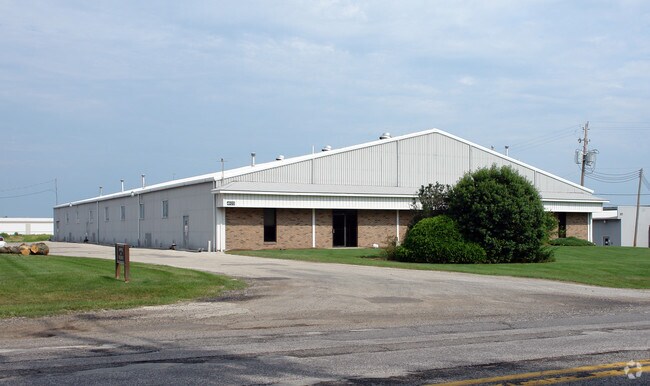
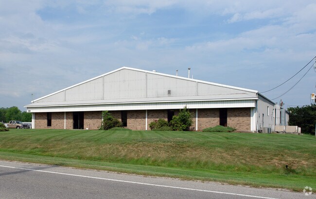
Property Detail
4920 Hudson Dr
Akron, OH
WESTERN RESERVE INDUSTRIAL SITES PART I LOT 5 ALL LOTS 3&4 P T PB 72 PG 39-40 3.0158 AC 100% CRA FOR 2008 NC OVER FOR TX YR 2019
56-19143
Summit
Industrialgeneral
Ohio
B and X Area of moderate flood hazard, usually the area between the limits of the 100-year and 500-year floods.
5,3,4
2025
3.02 AC
2026
Akron
530603
Cleveland
40,910 SF
NEARBY LISTINGS FOR SALE OR LEASE
DEMOGRAPHICS near 4920 Hudson Dr
1 mile
3 mile
5 mile
2025 Total Population
2,744
39,825
106,377
2030 Population
2,774
39,943
106,474
Pop Growth 2025-2030
+ 1.09%
+ 0.30%
+ 0.09%
Average Age
43
42
42
2025 Total Households
1,163
16,357
44,669
HH Growth 2025-2030
+ 1.03%
+ 0.37%
+ 0.11%
Median Household Inc
$69,642
$102,532
$93,569
Avg Household Size
2.30
2.40
2.30
2025 Avg HH Vehicles
2.00
2.00
2.00
Median Home Value
$254,334
$286,075
$268,110
Median Year Built
1978
1977
1974
Nearby Places
Map Layers
Map Styles
 Street
 Aerial
Layers
 Traffic
 Biking
Places
Listings with unknown addresses are not visible on the map
- Restaurants
- Banks
- Shops
- Fitness
- Groceries
PUBLIC TRANSPORTATION
COMMUTER RAIL
Drive
Walk
Distance
13 min
7.2 mi
Drive
Walk
Distance
17 min
8.3 mi
AIRPORT
Akron-Canton Regional
Drive
Walk
Distance
Akron-Canton Regional
32 min
22.7 mi
Cleveland-Hopkins International
Drive
Walk
Distance
Cleveland-Hopkins International
48 min
33.6 mi
Nearby Properties
Address
Land Use
TOTAL SIZE
Lot Size
Zoning
Address
Land Use
TOTAL SIZE
Lot Size
Zoning
193,683 SF
45.24 AC
Address
Land Use
TOTAL SIZE
Lot Size
Zoning
Address
Land Use
TOTAL SIZE
Lot Size
Zoning
243,073 SF
54.04 AC
Address
Land Use
TOTAL SIZE
Lot Size
Zoning
297,758 SF
23.28 AC
Address
Land Use
TOTAL SIZE
Lot Size
Zoning
114,568 SF
11.55 AC
Address
Land Use
TOTAL SIZE
Lot Size
Zoning
115,224 SF
10.30 AC
Address
Land Use
TOTAL SIZE
Lot Size
Zoning
1,302,677 SF
121.15 AC
Address
Land Use
TOTAL SIZE
Lot Size
Zoning
131,124 SF
29.45 AC
Address
Land Use
TOTAL SIZE
Lot Size
Zoning
52,646 SF
69.69 AC
Address
Land Use
TOTAL SIZE
Lot Size
Zoning
396,660 SF
31.89 AC
Address
Land Use
TOTAL SIZE
Lot Size
Zoning
15.41 AC
Address
Land Use
TOTAL SIZE
Lot Size
Zoning
118,740 SF
15.25 AC
Address
Land Use
TOTAL SIZE
Lot Size
Zoning
145,844 SF
9.80 AC
Address
Land Use
TOTAL SIZE
Lot Size
Zoning
Address
Land Use
TOTAL SIZE
Lot Size
Zoning
84,500 SF
8.14 AC
Address
Land Use
TOTAL SIZE
Lot Size
Zoning
625,640 SF
45.31 AC
Address
Land Use
TOTAL SIZE
Lot Size
Zoning
17,025 SF
216.50 AC
Address
Land Use
TOTAL SIZE
Lot Size
Zoning
Address
Land Use
TOTAL SIZE
Lot Size
Zoning
157,827 SF
26.63 AC
Address
Land Use
TOTAL SIZE
Lot Size
Zoning
90,820 SF
23.72 AC
Address
Land Use
TOTAL SIZE
Lot Size
Zoning
165,600 SF
11.21 AC
Address
Land Use
TOTAL SIZE
Lot Size
Zoning
68,855 SF
32.57 AC
Address
Land Use
TOTAL SIZE
Lot Size
Zoning
136,220 SF
33 AC
Address
Land Use
TOTAL SIZE
Lot Size
Zoning
140,288 SF
19.51 AC
Address
Land Use
TOTAL SIZE
Lot Size
Zoning
26,231 SF
14.40 AC
Address
Land Use
TOTAL SIZE
Lot Size
Zoning
21.80 AC
Address
Land Use
TOTAL SIZE
Lot Size
Zoning
12.94 AC
Address
Land Use
TOTAL SIZE
Lot Size
Zoning
Address
Land Use
TOTAL SIZE
Lot Size
Zoning
75,952 SF
4.88 AC
Address
Land Use
TOTAL SIZE
Lot Size
Zoning
31,442 SF
6.51 AC
The World's #1 Commercial Real Estate Marketplace
Connect with us
© 2026 CoStar Group
The information above has been obtained from sources believed reliable. While we do not doubt its accuracy we have not verified it and make no guarantee, warranty or representation about it. It is your responsibility to independently confirm its accuracy and completeness. Any projections, opinions, assumptions, or estimates used are for example only and do not represent the current or future performance of the property. The value of this transaction to you depends on tax and other factors which should be evaluated by your tax, financial, and legal advisors. You and your advisors should conduct a careful, independent investigation of the property to determine to your satisfaction the suitability of the property for your needs.