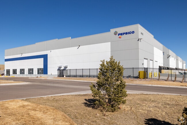
Property Record
4920 Integration Loop, Colorado Springs, CO 80916
NEARBY LISTINGS FOR SALE OR LEASE
Property Detail
4920 Integration Loop
Colorado Springs
Colorado Springs Airport Fil No 1F
Colorado Springs, CO
LOT 6 COLORADO SPRINGS AIRPORT FIL NO 1F
55050-01-006
El Paso
Commercialacreage
Colorado
2024
6
2025
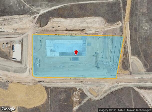
12.69 AC
004008
Southeast
DEMOGRAPHICS near 4920 Integration Loop
1 mile
3 mile
5 mile
2024 Total Population
72
33,213
117,357
2029 Population
76
34,055
122,234
Pop Growth 2024-2029
+ 5.56%
+ 2.54%
+ 4.16%
Average Age
29
36
34
2024 Total Households
22
10,994
39,371
HH Growth 2024-2029
+ 4.55%
+ 2.67%
+ 4.43%
Median Household Inc
$115,624
$78,097
$70,138
Avg Household Size
3.40
2.90
2.90
2024 Avg HH Vehicles
2.00
2.00
2.00
Median Home Value
$346,153
$327,875
$318,002
Median Year Built
2011
1992
1991
Nearby Places
Map Layers
Map Styles
 Street
 Aerial
Transit
 Traffic
 Biking
Places
Listings with unknown addresses are not visible on the map
- Restaurants
- Banks
- Shops
- Fitness
- Groceries
PUBLIC TRANSPORTATION
AIRPORT
City of Colorado Springs Municipal
Drive
Walk
Distance
City of Colorado Springs Municipal
17 min
8.3 mi
Freight Ports
Tulsa Port Of Catoosa
Drive
Walk
Distance
Tulsa Port Of Catoosa
743 min
694.7 mi
Nearby Properties
Address
Land Use
TOTAL SIZE
Lot Size
Zoning
Address
Land Use
TOTAL SIZE
Lot Size
Zoning
241,806 SF
937.06 AC
A-5 CAD-O
Address
Land Use
TOTAL SIZE
Lot Size
Zoning
3,486,127 SF
69.25 AC
APD APZ1 A
Address
Land Use
TOTAL SIZE
Lot Size
Zoning
339,516 SF
1,090.76 AC
APD RPZ AP
Address
Land Use
TOTAL SIZE
Lot Size
Zoning
6,000 SF
3,790.85 AC
Address
Land Use
TOTAL SIZE
Lot Size
Zoning
162,945 SF
20.05 AC
BP/CR CU A
Address
Land Use
TOTAL SIZE
Lot Size
Zoning
117,648 SF
3,971.89 AC
APD
Address
Land Use
TOTAL SIZE
Lot Size
Zoning
89,487 SF
Address
Land Use
TOTAL SIZE
Lot Size
Zoning
704,240 SF
41.99 AC
BP/CR UV A
Address
Land Use
TOTAL SIZE
Lot Size
Zoning
78,815 SF
Address
Land Use
TOTAL SIZE
Lot Size
Zoning
48,255 SF
17.35 AC
A-5 CAD-O
Address
Land Use
TOTAL SIZE
Lot Size
Zoning
278,331 SF
324.19 AC
Address
Land Use
TOTAL SIZE
Lot Size
Zoning
778.79 AC
APD AO RPZ
Address
Land Use
TOTAL SIZE
Lot Size
Zoning
91,446 SF
12.60 AC
BP AO
Address
Land Use
TOTAL SIZE
Lot Size
Zoning
92.06 AC
APD APZ1 A
Address
Land Use
TOTAL SIZE
Lot Size
Zoning
130,569 SF
3.23 AC
Address
Land Use
TOTAL SIZE
Lot Size
Zoning
135,296 SF
11.67 AC
BP/CR UV A
Address
Land Use
TOTAL SIZE
Lot Size
Zoning
131,040 SF
8.50 AC
BP/CR AO
Address
Land Use
TOTAL SIZE
Lot Size
Zoning
322,147 SF
35.10 AC
I-2 CAD-O
Address
Land Use
TOTAL SIZE
Lot Size
Zoning
43,914 SF
9.36 AC
A-5 CAD-O
Address
Land Use
TOTAL SIZE
Lot Size
Zoning
109,200 SF
6.13 AC
BP/CR AO
Address
Land Use
TOTAL SIZE
Lot Size
Zoning
168.20 AC
APD APZ1 A
Address
Land Use
TOTAL SIZE
Lot Size
Zoning
2.09 AC
MX-M CU AO
Address
Land Use
TOTAL SIZE
Lot Size
Zoning
19,308 SF
2.69 AC
RM-30 CAD-
Address
Land Use
TOTAL SIZE
Lot Size
Zoning
131,040 SF
9.68 AC
BP AO
Address
Land Use
TOTAL SIZE
Lot Size
Zoning
278,331 SF
6.39 AC
Address
Land Use
TOTAL SIZE
Lot Size
Zoning
99,960 SF
8.21 AC
BP AO
Address
Land Use
TOTAL SIZE
Lot Size
Zoning
19,813 SF
16.55 AC
A-5 CAD-O
Address
Land Use
TOTAL SIZE
Lot Size
Zoning
57,430 SF
9.19 AC
R-1 6 DF A
Address
Land Use
TOTAL SIZE
Lot Size
Zoning
66,780 SF
18.74 AC
APD APZ2 A
The World's #1 Commercial Real Estate Marketplace
Connect with us
© 2026 CoStar Group
The information above has been obtained from sources believed reliable. While we do not doubt its accuracy we have not verified it and make no guarantee, warranty or representation about it. It is your responsibility to independently confirm its accuracy and completeness. Any projections, opinions, assumptions, or estimates used are for example only and do not represent the current or future performance of the property. The value of this transaction to you depends on tax and other factors which should be evaluated by your tax, financial, and legal advisors. You and your advisors should conduct a careful, independent investigation of the property to determine to your satisfaction the suitability of the property for your needs.