Property Record
4942 Reed Rd, Columbus, OH 43220


NEARBY LISTINGS FOR SALE OR LEASE
Property Detail
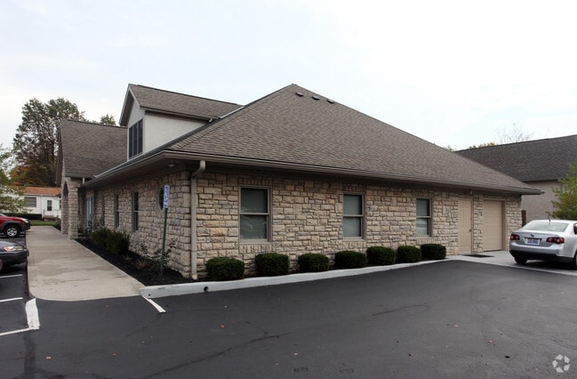
4942 Reed Rd
Columbus, OH
Perry Heights Addition No 2
010-231795
1750 MARSHLYN COURT PERRY HEIGHTS 2 111.01 L3 &30WS L4
Officebuilding
Franklin
X
Ohio
39049C0162K
3
2024
0.55 AC
2024
Bethel Rd
006353
Columbus
6,242 SF
DEMOGRAPHICS near 4942 Reed Rd
1 Mile
3 Mile
5 Mile
2024 Total Population
17,604
97,118
287,938
2029 Population
17,505
96,606
287,296
Pop Growth 2024-2029
(0.56%)
(0.53%)
(0.22%)
Average Age
40
41
38
2024 Total Households
8,508
43,638
124,784
HH Growth 2024-2029
(0.52%)
(0.47%)
(0.22%)
Median Household Inc
$62,685
$84,394
$77,691
Avg Household Size
2.00
2.20
2.20
2024 Avg HH Vehicles
2.00
2.00
2.00
Median Home Value
$293,098
$341,430
$322,380
Median Year Built
1976
1975
1975
Nearby Places
Map Layers
Map Styles
 Street
 Aerial
- Restaurants
- Banks
- Shops
- Fitness
- Groceries
PUBLIC TRANSPORTATION
AIRPORT
John Glenn Columbus International
DRIVE
WALK
Distance
John Glenn Columbus International
24 min
14.8 mi
Rickenbacker International
DRIVE
WALK
Distance
Rickenbacker International
38 min
25.0 mi
Nearby Properties
Address
Land Use
TOTAL SIZE
Lot Size
Zoning
Address
Land Use
TOTAL SIZE
Lot Size
Zoning
3,462,019 SF
54.42 AC
Address
Land Use
TOTAL SIZE
Lot Size
Zoning
182,845 SF
325.61 AC
Address
Land Use
TOTAL SIZE
Lot Size
Zoning
182,845 SF
325.61 AC
Address
Land Use
TOTAL SIZE
Lot Size
Zoning
240,144 SF
45.78 AC
Address
Land Use
TOTAL SIZE
Lot Size
Zoning
133,425 SF
20.51 AC
Address
Land Use
TOTAL SIZE
Lot Size
Zoning
260,092 SF
29.05 AC
Address
Land Use
TOTAL SIZE
Lot Size
Zoning
344,669 SF
8.45 AC
Address
Land Use
TOTAL SIZE
Lot Size
Zoning
517,875 SF
3.07 AC
Address
Land Use
TOTAL SIZE
Lot Size
Zoning
234,504 SF
5.40 AC
Address
Land Use
TOTAL SIZE
Lot Size
Zoning
561,921 SF
6.81 AC
Address
Land Use
TOTAL SIZE
Lot Size
Zoning
265,341 SF
19.35 AC
Address
Land Use
TOTAL SIZE
Lot Size
Zoning
286,169 SF
11.08 AC
Address
Land Use
TOTAL SIZE
Lot Size
Zoning
160,760 SF
14.29 AC
Address
Land Use
TOTAL SIZE
Lot Size
Zoning
273,578 SF
0.94 AC
Address
Land Use
TOTAL SIZE
Lot Size
Zoning
425,872 SF
10.05 AC
Address
Land Use
TOTAL SIZE
Lot Size
Zoning
200,609 SF
21.87 AC
Address
Land Use
TOTAL SIZE
Lot Size
Zoning
160,958 SF
11.93 AC
Address
Land Use
TOTAL SIZE
Lot Size
Zoning
115,032 SF
12.81 AC
Address
Land Use
TOTAL SIZE
Lot Size
Zoning
244,602 SF
27.30 AC
Address
Land Use
TOTAL SIZE
Lot Size
Zoning
142,979 SF
6.50 AC
Address
Land Use
TOTAL SIZE
Lot Size
Zoning
257,993 SF
9.98 AC
Address
Land Use
TOTAL SIZE
Lot Size
Zoning
101,650 SF
5.07 AC
Address
Land Use
TOTAL SIZE
Lot Size
Zoning
73,944 SF
11.03 AC
Address
Land Use
TOTAL SIZE
Lot Size
Zoning
115,392 SF
25 AC
Address
Land Use
TOTAL SIZE
Lot Size
Zoning
216,100 SF
28.17 AC
Address
Land Use
TOTAL SIZE
Lot Size
Zoning
273,112 SF
13.97 AC
Address
Land Use
TOTAL SIZE
Lot Size
Zoning
162,408 SF
1.73 AC
Address
Land Use
TOTAL SIZE
Lot Size
Zoning
123,149 SF
12.09 AC
Address
Land Use
TOTAL SIZE
Lot Size
Zoning
86,934 SF
8.80 AC
Address
Land Use
TOTAL SIZE
Lot Size
Zoning
147,582 SF
5.75 AC
The World's #1 Commercial Real Estate Marketplace
Connect with us
© 2025 CoStar Group
The information above has been obtained from sources believed reliable. While we do not doubt its accuracy we have not verified it and make no guarantee, warranty or representation about it. It is your responsibility to independently confirm its accuracy and completeness. Any projections, opinions, assumptions, or estimates used are for example only and do not represent the current or future performance of the property. The value of this transaction to you depends on tax and other factors which should be evaluated by your tax, financial, and legal advisors. You and your advisors should conduct a careful, independent investigation of the property to determine to your satisfaction the suitability of the property for your needs.