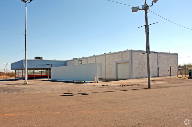
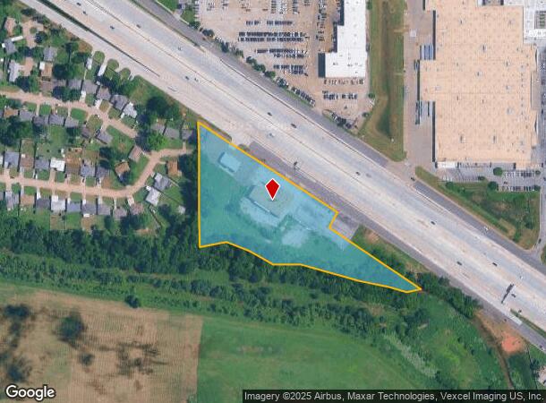
Property Record
4920 Tinker Diagonal, Oklahoma City, OK 73115
NEARBY LISTINGS FOR SALE OR LEASE
Property Detail
4920 Tinker Diagonal
153911220
Unpltd Pt Sec 08 11N 2W
Officebuilding
UNPLTD PT SEC 08 11N 2W PT OF NE4 SEC 8 11N 2W BEG 1765.50FT W & 573.47FT S OF NE/C NE4 TH S497.33FT TO CENTERLINE OF CRUTCHO CREEK TH NE38.71FT NE57.97FT SE90.74FT SE94.03FT NE99.02FT SE217.17FT SE108.33FT SE65.46FT NE46.30FT NW387.89FT NE70FT NW326
AE
Oklahoma
40109C0310H
Oklahoma
2023
4.97 AC
2024
South
107804
Oklahoma City
10,798 SF
Oklahoma City, OK
DEMOGRAPHICS near 4920 Tinker Diagonal
1 Mile
3 Mile
5 Mile
2024 Total Population
8,321
68,144
140,172
2029 Population
8,498
70,435
144,956
Pop Growth 2024-2029
+ 2.13%
+ 3.36%
+ 3.41%
Average Age
38
36
37
2024 Total Households
3,431
27,184
56,043
HH Growth 2024-2029
+ 2.19%
+ 3.17%
+ 3.38%
Median Household Inc
$43,661
$48,236
$47,629
Avg Household Size
2.30
2.40
2.40
2024 Avg HH Vehicles
2.00
2.00
2.00
Median Home Value
$73,750
$106,509
$118,697
Median Year Built
1960
1969
1972
Nearby Places
- Restaurants
- Banks
- Shops
- Fitness
- Groceries
PUBLIC TRANSPORTATION
COMMUTER RAIL
Oklahoma City (Heartland Flyer - Amtrak)
DRIVE
WALK
Distance
Oklahoma City (Heartland Flyer - Amtrak)
9 min
6.4 mi
AIRPORT
Will Rogers World
DRIVE
WALK
Distance
Will Rogers World
27 min
15.8 mi
Freight Ports
Tulsa Port Of Catoosa
DRIVE
WALK
Distance
Tulsa Port Of Catoosa
136 min
124.5 mi
Nearby Properties
Address
Land Use
TOTAL SIZE
Lot Size
Zoning
Address
Land Use
TOTAL SIZE
Lot Size
Zoning
318,692 SF
15.25 AC
Address
Land Use
TOTAL SIZE
Lot Size
Zoning
142,772 SF
11.07 AC
Address
Land Use
TOTAL SIZE
Lot Size
Zoning
242,484 SF
13.18 AC
Address
Land Use
TOTAL SIZE
Lot Size
Zoning
95,330 SF
25.68 AC
Address
Land Use
TOTAL SIZE
Lot Size
Zoning
431,366 SF
17.57 AC
Address
Land Use
TOTAL SIZE
Lot Size
Zoning
84,940 SF
9.58 AC
Address
Land Use
TOTAL SIZE
Lot Size
Zoning
119,916 SF
15.06 AC
I-3
Address
Land Use
TOTAL SIZE
Lot Size
Zoning
100,000 SF
11.18 AC
I-2
Address
Land Use
TOTAL SIZE
Lot Size
Zoning
203,263 SF
45.46 AC
Address
Land Use
TOTAL SIZE
Lot Size
Zoning
14,992 SF
1.34 AC
Address
Land Use
TOTAL SIZE
Lot Size
Zoning
124,997 SF
9.80 AC
Address
Land Use
TOTAL SIZE
Lot Size
Zoning
126,556 SF
6.74 AC
R-4
Address
Land Use
TOTAL SIZE
Lot Size
Zoning
145,328 SF
14.95 AC
R-4
Address
Land Use
TOTAL SIZE
Lot Size
Zoning
209,552 SF
11.67 AC
R-4
Address
Land Use
TOTAL SIZE
Lot Size
Zoning
35,245 SF
2.60 AC
Address
Land Use
TOTAL SIZE
Lot Size
Zoning
171,622 SF
9.74 AC
Address
Land Use
TOTAL SIZE
Lot Size
Zoning
8,811 SF
1.73 AC
Address
Land Use
TOTAL SIZE
Lot Size
Zoning
109,637 SF
10.14 AC
I-2
Address
Land Use
TOTAL SIZE
Lot Size
Zoning
164,256 SF
8.38 AC
R-4
Address
Land Use
TOTAL SIZE
Lot Size
Zoning
94,261 SF
13.12 AC
Address
Land Use
TOTAL SIZE
Lot Size
Zoning
180,937 SF
9.92 AC
Address
Land Use
TOTAL SIZE
Lot Size
Zoning
54,338 SF
10.24 AC
Address
Land Use
TOTAL SIZE
Lot Size
Zoning
141,254 SF
12.15 AC
Address
Land Use
TOTAL SIZE
Lot Size
Zoning
74,184 SF
3.43 AC
Address
Land Use
TOTAL SIZE
Lot Size
Zoning
208,900 SF
10.15 AC
Address
Land Use
TOTAL SIZE
Lot Size
Zoning
100,092 SF
5.37 AC
Address
Land Use
TOTAL SIZE
Lot Size
Zoning
62,506 SF
5.97 AC
Address
Land Use
TOTAL SIZE
Lot Size
Zoning
141,540 SF
11.09 AC
I-2
Address
Land Use
TOTAL SIZE
Lot Size
Zoning
47,040 SF
5.41 AC
Address
Land Use
TOTAL SIZE
Lot Size
Zoning
16,517 SF
1.12 AC
The World's #1 Commercial Real Estate Marketplace
Connect with us
© 2025 CoStar Group
The information above has been obtained from sources believed reliable. While we do not doubt its accuracy we have not verified it and make no guarantee, warranty or representation about it. It is your responsibility to independently confirm its accuracy and completeness. Any projections, opinions, assumptions, or estimates used are for example only and do not represent the current or future performance of the property. The value of this transaction to you depends on tax and other factors which should be evaluated by your tax, financial, and legal advisors. You and your advisors should conduct a careful, independent investigation of the property to determine to your satisfaction the suitability of the property for your needs.