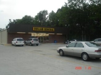
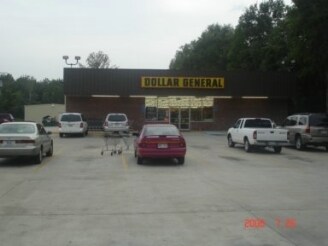
Property Record
49203 Highway 51, Tickfaw, LA 70466

Property Detail
49203 Highway 51
03390918
2.00A 1.58A SEC 34 T5SRE 0.42A SEC 35 T5SR7E B459 P16 B803 P605 B955 P653 B968 P13 B972 P322 B1421 P205
Commercialnec
Tangipahoa
AE The base floodplain where base flood elevations are provided. AE Zones are now used on new format FIRMs instead of A1-A30 Zones.
Louisiana
2025
2 AC
2025
Louisiana South Area
9539001017
Other Market Areas
8,125 SF
Hammond, LA
NEARBY LISTINGS FOR SALE OR LEASE
-
-
View all Tickfaw listings for sale on LoopNet.com
DEMOGRAPHICS near 49203 Highway 51
1 mile
3 mile
5 mile
2025 Total Population
917
10,038
34,865
2030 Population
931
10,252
36,050
Pop Growth 2025-2030
+ 1.53%
+ 2.13%
+ 3.40%
Average Age
40
38
36
2025 Total Households
362
4,109
13,413
HH Growth 2025-2030
+ 1.66%
+ 2.26%
+ 3.64%
Median Household Inc
$39,845
$47,556
$50,412
Avg Household Size
2.50
2.40
2.40
2025 Avg HH Vehicles
2.00
2.00
2.00
Median Home Value
$176,315
$185,903
$207,877
Median Year Built
1988
1989
1987
Nearby Places
Map Layers
Map Styles
 Street
 Aerial
Layers
 Traffic
 Biking
Places
Listings with unknown addresses are not visible on the map
- Restaurants
- Banks
- Shops
- Fitness
- Groceries
PUBLIC TRANSPORTATION
COMMUTER RAIL
Hammond Amtrak Station (City of New Orleans - Amtrak)
Drive
Walk
Distance
Hammond Amtrak Station (City of New Orleans - Amtrak)
9 min
5.4 mi
Freight Ports
Port of Greater Baton Rouge
Drive
Walk
Distance
Port of Greater Baton Rouge
66 min
53.3 mi
Nearby Properties
Address
Land Use
TOTAL SIZE
Lot Size
Zoning
Address
Land Use
TOTAL SIZE
Lot Size
Zoning
4,664 SF
8.14 AC
Address
Land Use
TOTAL SIZE
Lot Size
Zoning
6,252 SF
2.89 AC
Address
Land Use
TOTAL SIZE
Lot Size
Zoning
5,700 SF
2.50 AC
Address
Land Use
TOTAL SIZE
Lot Size
Zoning
50,020 SF
67.83 AC
Address
Land Use
TOTAL SIZE
Lot Size
Zoning
68,080 SF
20.06 AC
Address
Land Use
TOTAL SIZE
Lot Size
Zoning
11,904 SF
1.51 AC
Address
Land Use
TOTAL SIZE
Lot Size
Zoning
6,629 SF
10 AC
Address
Land Use
TOTAL SIZE
Lot Size
Zoning
12,726 SF
1.54 AC
Address
Land Use
TOTAL SIZE
Lot Size
Zoning
11,450 SF
9 AC
Address
Land Use
TOTAL SIZE
Lot Size
Zoning
15,000 SF
Address
Land Use
TOTAL SIZE
Lot Size
Zoning
34,000 SF
7.20 AC
Address
Land Use
TOTAL SIZE
Lot Size
Zoning
4,712 SF
2.04 AC
Address
Land Use
TOTAL SIZE
Lot Size
Zoning
20,250 SF
3.73 AC
Address
Land Use
TOTAL SIZE
Lot Size
Zoning
9,196 SF
0.78 AC
Address
Land Use
TOTAL SIZE
Lot Size
Zoning
8,172 SF
1.36 AC
Address
Land Use
TOTAL SIZE
Lot Size
Zoning
8,000 SF
1 AC
Address
Land Use
TOTAL SIZE
Lot Size
Zoning
4,250 SF
1.50 AC
Address
Land Use
TOTAL SIZE
Lot Size
Zoning
1,476 SF
2 AC
Address
Land Use
TOTAL SIZE
Lot Size
Zoning
4,020 SF
2.72 AC
Address
Land Use
TOTAL SIZE
Lot Size
Zoning
6,596 SF
5.88 AC
Address
Land Use
TOTAL SIZE
Lot Size
Zoning
3,168 SF
0.68 AC
Address
Land Use
TOTAL SIZE
Lot Size
Zoning
3,735 SF
0.01 AC
Address
Land Use
TOTAL SIZE
Lot Size
Zoning
6,499 SF
4.21 AC
Address
Land Use
TOTAL SIZE
Lot Size
Zoning
16,000 SF
7.59 AC
Address
Land Use
TOTAL SIZE
Lot Size
Zoning
17,157 SF
2.48 AC
Address
Land Use
TOTAL SIZE
Lot Size
Zoning
6,324 SF
1.18 AC
Address
Land Use
TOTAL SIZE
Lot Size
Zoning
5,655 SF
12.07 AC
Address
Land Use
TOTAL SIZE
Lot Size
Zoning
5,750 SF
0.83 AC
Address
Land Use
TOTAL SIZE
Lot Size
Zoning
4,602 SF
1.51 AC
Address
Land Use
TOTAL SIZE
Lot Size
Zoning
10,197 SF
1.12 AC
The World's #1 Commercial Real Estate Marketplace
Connect with us
© 2026 CoStar Group
The information above has been obtained from sources believed reliable. While we do not doubt its accuracy we have not verified it and make no guarantee, warranty or representation about it. It is your responsibility to independently confirm its accuracy and completeness. Any projections, opinions, assumptions, or estimates used are for example only and do not represent the current or future performance of the property. The value of this transaction to you depends on tax and other factors which should be evaluated by your tax, financial, and legal advisors. You and your advisors should conduct a careful, independent investigation of the property to determine to your satisfaction the suitability of the property for your needs.