Property Record
4924 Tapawingo Trl, Greensboro, NC 27406

NEARBY LISTINGS FOR SALE OR LEASE
-
-
View all Greensboro listings for sale on LoopNet.com
Property Detail
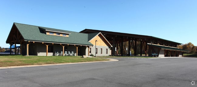
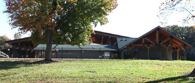
4924 Tapawingo Trl
Greensboro-High Point, NC
Outdoor Cntr Ymca
0116415
L1 PB 146-16 OUTDOOR CNTR YMCA PL:146-16
Parkplaygroundpicnicarea
Guilford
AE
North Carolina
3710789200J
1
0
93.77 AC
2025
SE Guilford County
017200
Greensboro/Winston-Salem
4,393 SF
DEMOGRAPHICS near 4924 Tapawingo Trl
1 Mile
3 Mile
5 Mile
2024 Total Population
677
13,825
39,722
2029 Population
671
13,676
39,532
Pop Growth 2024-2029
(0.89%)
(1.08%)
(0.48%)
Average Age
41
41
40
2024 Total Households
252
5,228
15,396
HH Growth 2024-2029
(0.79%)
(1.07%)
(0.45%)
Median Household Inc
$69,329
$71,055
$59,745
Avg Household Size
2.60
2.60
2.50
2024 Avg HH Vehicles
2.00
2.00
2.00
Median Home Value
$223,936
$216,109
$189,884
Median Year Built
1998
1995
1988
Nearby Places
Map Layers
Map Styles
 Street
 Aerial
- Restaurants
- Banks
- Shops
- Fitness
- Groceries
PUBLIC TRANSPORTATION
AIRPORT
Piedmont Triad International
DRIVE
WALK
Distance
Piedmont Triad International
33 min
21.5 mi
Freight Ports
Virginia Port Authority - Richmond
DRIVE
WALK
Distance
Virginia Port Authority - Richmond
223 min
193.8 mi
Nearby Properties
Address
Land Use
TOTAL SIZE
Lot Size
Zoning
Address
Land Use
TOTAL SIZE
Lot Size
Zoning
402,136 SF
31.27 AC
HI
Address
Land Use
TOTAL SIZE
Lot Size
Zoning
364,783 SF
30.12 AC
RM-18
Address
Land Use
TOTAL SIZE
Lot Size
Zoning
418,596 SF
23.53 AC
LI
Address
Land Use
TOTAL SIZE
Lot Size
Zoning
505,615 SF
39.50 AC
LI
Address
Land Use
TOTAL SIZE
Lot Size
Zoning
281,330 SF
21.18 AC
HI
Address
Land Use
TOTAL SIZE
Lot Size
Zoning
293,760 SF
21.94 AC
LI
Address
Land Use
TOTAL SIZE
Lot Size
Zoning
363,920 SF
34.27 AC
LI
Address
Land Use
TOTAL SIZE
Lot Size
Zoning
419,126 SF
33.68 AC
LI
Address
Land Use
TOTAL SIZE
Lot Size
Zoning
240,170 SF
14.01 AC
LI
Address
Land Use
TOTAL SIZE
Lot Size
Zoning
301,592 SF
19.38 AC
LI
Address
Land Use
TOTAL SIZE
Lot Size
Zoning
652,985 SF
104.62 AC
BP
Address
Land Use
TOTAL SIZE
Lot Size
Zoning
128,500 SF
14.15 AC
LI
Address
Land Use
TOTAL SIZE
Lot Size
Zoning
153,900 SF
14.23 AC
LI
Address
Land Use
TOTAL SIZE
Lot Size
Zoning
146,028 SF
11.36 AC
BP
Address
Land Use
TOTAL SIZE
Lot Size
Zoning
2,768 SF
151.17 AC
HI
Address
Land Use
TOTAL SIZE
Lot Size
Zoning
39,775 SF
2.28 AC
C-M
Address
Land Use
TOTAL SIZE
Lot Size
Zoning
107,806 SF
33.49 AC
PI
Address
Land Use
TOTAL SIZE
Lot Size
Zoning
66,372 SF
17.77 AC
LI
Address
Land Use
TOTAL SIZE
Lot Size
Zoning
16,920 SF
15.03 AC
LI
Address
Land Use
TOTAL SIZE
Lot Size
Zoning
2,444 SF
263.08 AC
AG
Address
Land Use
TOTAL SIZE
Lot Size
Zoning
4,410 SF
6.15 AC
C-M
Address
Land Use
TOTAL SIZE
Lot Size
Zoning
53,332 SF
34.48 AC
PI
Address
Land Use
TOTAL SIZE
Lot Size
Zoning
4,938 SF
2.19 AC
C-M
Address
Land Use
TOTAL SIZE
Lot Size
Zoning
26,764 SF
186.74 AC
RS-40
Address
Land Use
TOTAL SIZE
Lot Size
Zoning
32,672 SF
17.30 AC
RS-40
Address
Land Use
TOTAL SIZE
Lot Size
Zoning
22.93 AC
LI
Address
Land Use
TOTAL SIZE
Lot Size
Zoning
9,159 SF
3.33 AC
C-M
Address
Land Use
TOTAL SIZE
Lot Size
Zoning
2,943 SF
99.78 AC
AG
Address
Land Use
TOTAL SIZE
Lot Size
Zoning
14,036 SF
15 AC
PI
The World's #1 Commercial Real Estate Marketplace
Connect with us
© 2026 CoStar Group
The information above has been obtained from sources believed reliable. While we do not doubt its accuracy we have not verified it and make no guarantee, warranty or representation about it. It is your responsibility to independently confirm its accuracy and completeness. Any projections, opinions, assumptions, or estimates used are for example only and do not represent the current or future performance of the property. The value of this transaction to you depends on tax and other factors which should be evaluated by your tax, financial, and legal advisors. You and your advisors should conduct a careful, independent investigation of the property to determine to your satisfaction the suitability of the property for your needs.