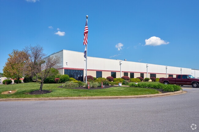
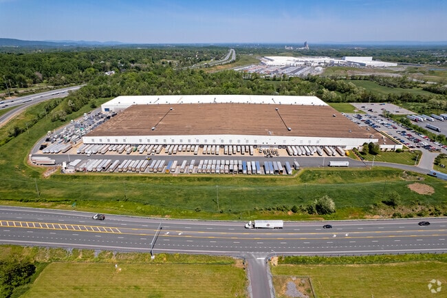
Property Record
4925 Tabler Station Rd, Inwood, WV 25428

NEARBY LISTINGS FOR SALE OR LEASE
Property Detail
4925 Tabler Station Rd
Hagerstown-Martinsburg, MD-WV
12.93 ACRE. NEW LOT C SURVEY PLAT MEMPHIS SEC II LLC
01-14-00100011
Berkeley
Warehouse
West Virginia
X
c
54003C0145E
30.56 AC
2025
Berkeley County
2025
Washington, DC
972105
DEMOGRAPHICS near 4925 Tabler Station Rd
1 Mile
3 Mile
5 Mile
2024 Total Population
943
14,463
47,557
2029 Population
1,092
16,667
54,590
Pop Growth 2024-2029
+ 15.80%
+ 15.24%
+ 14.79%
Average Age
39
39
39
2024 Total Households
366
5,568
18,766
HH Growth 2024-2029
+ 16.39%
+ 15.84%
+ 15.41%
Median Household Inc
$88,855
$79,988
$69,295
Avg Household Size
2.60
2.60
2.50
2024 Avg HH Vehicles
3.00
2.00
2.00
Median Home Value
$247,641
$234,547
$218,753
Median Year Built
1998
1999
1990
Nearby Places
Map Layers
Map Styles
 Street
 Aerial
- Restaurants
- Banks
- Shops
- Fitness
- Groceries
PUBLIC TRANSPORTATION
COMMUTER RAIL
Martinsburg W Va Marc (BRUNSWICK - WASHINGTON - Maryland Transit Administration)
DRIVE
WALK
Distance
Martinsburg W Va Marc (BRUNSWICK - WASHINGTON - Maryland Transit Administration)
10 min
5.9 mi
Martinsburg (Brunswick Line - Maryland Area Regional Commuter Trains (The MARC))
DRIVE
WALK
Distance
Martinsburg (Brunswick Line - Maryland Area Regional Commuter Trains (The MARC))
10 min
5.9 mi
AIRPORT
Hagerstown Regional/Richard A Henson Field
DRIVE
WALK
Distance
Hagerstown Regional/Richard A Henson Field
36 min
29.1 mi
Freight Ports
Port of Baltimore
DRIVE
WALK
Distance
Port of Baltimore
115 min
98.3 mi
Nearby Properties
Address
Land Use
TOTAL SIZE
Lot Size
Zoning
Address
Land Use
TOTAL SIZE
Lot Size
Zoning
440.34 AC
Address
Land Use
TOTAL SIZE
Lot Size
Zoning
76.91 AC
Address
Land Use
TOTAL SIZE
Lot Size
Zoning
68.83 AC
Address
Land Use
TOTAL SIZE
Lot Size
Zoning
189.79 AC
Address
Land Use
TOTAL SIZE
Lot Size
Zoning
39.32 AC
Address
Land Use
TOTAL SIZE
Lot Size
Zoning
30.51 AC
Address
Land Use
TOTAL SIZE
Lot Size
Zoning
Address
Land Use
TOTAL SIZE
Lot Size
Zoning
26.91 AC
Address
Land Use
TOTAL SIZE
Lot Size
Zoning
22.89 AC
Address
Land Use
TOTAL SIZE
Lot Size
Zoning
16.74 AC
Address
Land Use
TOTAL SIZE
Lot Size
Zoning
40.83 AC
Address
Land Use
TOTAL SIZE
Lot Size
Zoning
22.14 AC
Address
Land Use
TOTAL SIZE
Lot Size
Zoning
Address
Land Use
TOTAL SIZE
Lot Size
Zoning
Address
Land Use
TOTAL SIZE
Lot Size
Zoning
2,000 SF
19.86 AC
Address
Land Use
TOTAL SIZE
Lot Size
Zoning
Address
Land Use
TOTAL SIZE
Lot Size
Zoning
2.46 AC
Address
Land Use
TOTAL SIZE
Lot Size
Zoning
4.40 AC
Address
Land Use
TOTAL SIZE
Lot Size
Zoning
71.35 AC
Address
Land Use
TOTAL SIZE
Lot Size
Zoning
Address
Land Use
TOTAL SIZE
Lot Size
Zoning
73.47 AC
Address
Land Use
TOTAL SIZE
Lot Size
Zoning
10.02 AC
Address
Land Use
TOTAL SIZE
Lot Size
Zoning
Address
Land Use
TOTAL SIZE
Lot Size
Zoning
8.51 AC
Address
Land Use
TOTAL SIZE
Lot Size
Zoning
22.82 AC
Address
Land Use
TOTAL SIZE
Lot Size
Zoning
2,526 SF
40.70 AC
Address
Land Use
TOTAL SIZE
Lot Size
Zoning
Address
Land Use
TOTAL SIZE
Lot Size
Zoning
25.21 AC
The World's #1 Commercial Real Estate Marketplace
Connect with us
© 2026 CoStar Group
The information above has been obtained from sources believed reliable. While we do not doubt its accuracy we have not verified it and make no guarantee, warranty or representation about it. It is your responsibility to independently confirm its accuracy and completeness. Any projections, opinions, assumptions, or estimates used are for example only and do not represent the current or future performance of the property. The value of this transaction to you depends on tax and other factors which should be evaluated by your tax, financial, and legal advisors. You and your advisors should conduct a careful, independent investigation of the property to determine to your satisfaction the suitability of the property for your needs.