Property Record
49251 Calhoun St, Indio, CA 92201


Property Detail
49251 Calhoun St
Riverside-San Bernardino-Ontario, CA
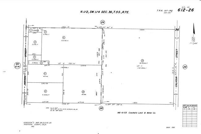
38.80 ACRES IN POR LOT 11 MB 004/053 COACHELLA LAND & WATER CO
612-260-010
RIVERSIDE
Agriculturalland
California
A1
11
B and X Area of moderate flood hazard, usually the area between the limits of the 100-year and 500-year floods.
38.80 AC
2024
Coachella Valley
2025
Inland Empire (California)
045501
NEARBY LISTINGS FOR SALE OR LEASE
DEMOGRAPHICS near 49251 Calhoun St
1 mile
3 mile
5 mile
2025 Total Population
14,931
95,410
164,050
2030 Population
15,417
98,484
171,542
Pop Growth 2025-2030
+ 3.25%
+ 3.22%
+ 4.57%
Average Age
37
36
40
2025 Total Households
4,128
26,737
51,549
HH Growth 2025-2030
+ 4.02%
+ 3.40%
+ 5.27%
Median Household Inc
$86,354
$69,026
$83,250
Avg Household Size
3.50
3.40
3.10
2025 Avg HH Vehicles
2.00
2.00
2.00
Median Home Value
$465,980
$426,279
$549,131
Median Year Built
2003
1991
1998
Nearby Places
Map Layers
Map Styles
 Street
 Aerial
Layers
 Traffic
 Biking
Places
Listings with unknown addresses are not visible on the map
- Restaurants
- Banks
- Shops
- Fitness
- Groceries
PUBLIC TRANSPORTATION
AIRPORT
Palm Springs International
Drive
Walk
Distance
Palm Springs International
33 min
24.4 mi
Freight Ports
Port of San Diego
Drive
Walk
Distance
Port of San Diego
178 min
148.6 mi
SALE & LEASE HISTORY
LISTING DATE
SALE/LEASE

Sep 23, 2020
For Sale
Nearby Properties
Address
Land Use
TOTAL SIZE
Lot Size
Zoning
Address
Land Use
TOTAL SIZE
Lot Size
Zoning
73,832 SF
7.71 AC
Address
Land Use
TOTAL SIZE
Lot Size
Zoning
128,503 SF
6.25 AC
R3
Address
Land Use
TOTAL SIZE
Lot Size
Zoning
189,101 SF
8.98 AC
C1
Address
Land Use
TOTAL SIZE
Lot Size
Zoning
55,072 SF
6.88 AC
C2
Address
Land Use
TOTAL SIZE
Lot Size
Zoning
170,272 SF
16.28 AC
Address
Land Use
TOTAL SIZE
Lot Size
Zoning
171,910 SF
14.89 AC
C1
Address
Land Use
TOTAL SIZE
Lot Size
Zoning
52,901 SF
6 AC
Address
Land Use
TOTAL SIZE
Lot Size
Zoning
55,695 SF
10.60 AC
C1
Address
Land Use
TOTAL SIZE
Lot Size
Zoning
2,841 SF
7.51 AC
A1
Address
Land Use
TOTAL SIZE
Lot Size
Zoning
39,776 SF
4.46 AC
C2
Address
Land Use
TOTAL SIZE
Lot Size
Zoning
104,741 SF
5.80 AC
R1
Address
Land Use
TOTAL SIZE
Lot Size
Zoning
67,787 SF
3.93 AC
R3
Address
Land Use
TOTAL SIZE
Lot Size
Zoning
114,716 SF
6.38 AC
Address
Land Use
TOTAL SIZE
Lot Size
Zoning
41,091 SF
4.65 AC
Address
Land Use
TOTAL SIZE
Lot Size
Zoning
105,122 SF
2.23 AC
Address
Land Use
TOTAL SIZE
Lot Size
Zoning
100,110 SF
4.03 AC
Address
Land Use
TOTAL SIZE
Lot Size
Zoning
86,479 SF
6.46 AC
Address
Land Use
TOTAL SIZE
Lot Size
Zoning
44,511 SF
9.40 AC
CM
Address
Land Use
TOTAL SIZE
Lot Size
Zoning
34,312 SF
3.15 AC
Address
Land Use
TOTAL SIZE
Lot Size
Zoning
84,490 SF
4.20 AC
R3
Address
Land Use
TOTAL SIZE
Lot Size
Zoning
185,793 SF
9.50 AC
RO
Address
Land Use
TOTAL SIZE
Lot Size
Zoning
93,200 SF
8.84 AC
RO
Address
Land Use
TOTAL SIZE
Lot Size
Zoning
40,380 SF
17.55 AC
Address
Land Use
TOTAL SIZE
Lot Size
Zoning
30,000 SF
2.98 AC
Address
Land Use
TOTAL SIZE
Lot Size
Zoning
24,000 SF
6.16 AC
R1
Address
Land Use
TOTAL SIZE
Lot Size
Zoning
53,705 SF
5.10 AC
A1
Address
Land Use
TOTAL SIZE
Lot Size
Zoning
44,000 SF
2.44 AC
O
Address
Land Use
TOTAL SIZE
Lot Size
Zoning
31,708 SF
5.07 AC
R3
Address
Land Use
TOTAL SIZE
Lot Size
Zoning
58,581 SF
6.05 AC
The World's #1 Commercial Real Estate Marketplace
Connect with us
© 2026 CoStar Group
The information above has been obtained from sources believed reliable. While we do not doubt its accuracy we have not verified it and make no guarantee, warranty or representation about it. It is your responsibility to independently confirm its accuracy and completeness. Any projections, opinions, assumptions, or estimates used are for example only and do not represent the current or future performance of the property. The value of this transaction to you depends on tax and other factors which should be evaluated by your tax, financial, and legal advisors. You and your advisors should conduct a careful, independent investigation of the property to determine to your satisfaction the suitability of the property for your needs.