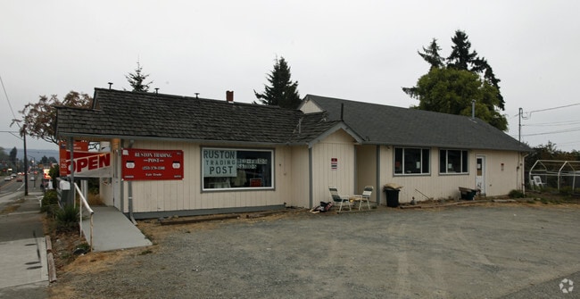
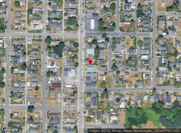
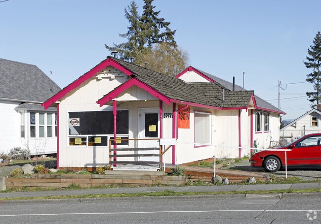
Property Record
4927 N Pearl St, Ruston, WA 98407
NEARBY LISTINGS FOR SALE OR LEASE
Property Detail
4927 N Pearl St
Seattle-Tacoma-Bellevue, WA
Argyle Add To Ruston
222500-0150
SOME INFO KEYED FROM LEGAL DESCRIPTION, BUT COMPLETE LEGAL NOT CAPTURED
Storebuilding
Pierce
X
Washington
53033C1200G
11
2024
0.12 AC
2025
Tacoma Suburban
060300
Seattle/Puget Sound
1,324 SF
DEMOGRAPHICS near 4927 N Pearl St
1 Mile
3 Mile
5 Mile
2024 Total Population
10,634
50,015
145,346
2029 Population
11,062
51,603
150,466
Pop Growth 2024-2029
+ 4.02%
+ 3.18%
+ 3.52%
Average Age
44
43
42
2024 Total Households
4,725
21,538
63,254
HH Growth 2024-2029
+ 4.30%
+ 3.38%
+ 3.72%
Median Household Inc
$101,044
$101,724
$88,908
Avg Household Size
2.20
2.20
2.20
2024 Avg HH Vehicles
2.00
2.00
2.00
Median Home Value
$574,770
$591,130
$583,419
Median Year Built
1982
1970
1972
Nearby Places
Map Layers
Map Styles
 Street
 Aerial
- Restaurants
- Banks
- Shops
- Fitness
- Groceries
PUBLIC TRANSPORTATION
COMMUTER RAIL
DRIVE
WALK
Distance
16 min
7.3 mi
Tacoma Dome Station (Sounder South Line - Central Puget Sound Regional Transit Authority Rail (Link Light Rail/Sounder), Tacoma Link - Central Puget Sound Regional Transit Authority Rail (Link Light Rail/Sounder))
DRIVE
WALK
Distance
Tacoma Dome Station (Sounder South Line - Central Puget Sound Regional Transit Authority Rail (Link Light Rail/Sounder), Tacoma Link - Central Puget Sound Regional Transit Authority Rail (Link Light Rail/Sounder))
17 min
8.3 mi
AIRPORT
Seattle-Tacoma International
DRIVE
WALK
Distance
Seattle-Tacoma International
47 min
28.7 mi
Freight Ports
Port of Tacoma
DRIVE
WALK
Distance
Port of Tacoma
19 min
8.1 mi
Nearby Properties
Address
Land Use
TOTAL SIZE
Lot Size
Zoning
Address
Land Use
TOTAL SIZE
Lot Size
Zoning
1,173,718 SF
79.33 AC
R2
Address
Land Use
TOTAL SIZE
Lot Size
Zoning
17,111 SF
647.26 AC
R1
Address
Land Use
TOTAL SIZE
Lot Size
Zoning
261,002 SF
28.34 AC
TAC
Address
Land Use
TOTAL SIZE
Lot Size
Zoning
196,380 SF
8.33 AC
R4L
Address
Land Use
TOTAL SIZE
Lot Size
Zoning
189,797 SF
18.06 AC
RB-2
Address
Land Use
TOTAL SIZE
Lot Size
Zoning
329,594 SF
10.60 AC
C2
Address
Land Use
TOTAL SIZE
Lot Size
Zoning
184,782 SF
23.38 AC
B-2
Address
Land Use
TOTAL SIZE
Lot Size
Zoning
228,761 SF
4 AC
R10
Address
Land Use
TOTAL SIZE
Lot Size
Zoning
156,149 SF
9.06 AC
R4L
Address
Land Use
TOTAL SIZE
Lot Size
Zoning
158,408 SF
2.14 AC
Address
Land Use
TOTAL SIZE
Lot Size
Zoning
114,869 SF
7.46 AC
RCX
Address
Land Use
TOTAL SIZE
Lot Size
Zoning
149,068 SF
8.92 AC
R4L
Address
Land Use
TOTAL SIZE
Lot Size
Zoning
102,723 SF
16.16 AC
R4
Address
Land Use
TOTAL SIZE
Lot Size
Zoning
91,277 SF
5.08 AC
GIGH
Address
Land Use
TOTAL SIZE
Lot Size
Zoning
191,027 SF
11.69 AC
R4
Address
Land Use
TOTAL SIZE
Lot Size
Zoning
143,066 SF
2.25 AC
Address
Land Use
TOTAL SIZE
Lot Size
Zoning
62,203 SF
4.95 AC
R4
Address
Land Use
TOTAL SIZE
Lot Size
Zoning
127,898 SF
12.18 AC
R4L
Address
Land Use
TOTAL SIZE
Lot Size
Zoning
58,795 SF
9.71 AC
R2
Address
Land Use
TOTAL SIZE
Lot Size
Zoning
67,823 SF
7.22 AC
RCX
Address
Land Use
TOTAL SIZE
Lot Size
Zoning
110,156 SF
9.54 AC
B-2
Address
Land Use
TOTAL SIZE
Lot Size
Zoning
107,968 SF
6.49 AC
R4
Address
Land Use
TOTAL SIZE
Lot Size
Zoning
99,524 SF
2.50 AC
R5
Address
Land Use
TOTAL SIZE
Lot Size
Zoning
88,720 SF
4.27 AC
R4L
Address
Land Use
TOTAL SIZE
Lot Size
Zoning
105,000 SF
8.56 AC
C2
Address
Land Use
TOTAL SIZE
Lot Size
Zoning
124,750 SF
14.38 AC
R2
Address
Land Use
TOTAL SIZE
Lot Size
Zoning
81,328 SF
8 AC
R2
Address
Land Use
TOTAL SIZE
Lot Size
Zoning
149,856 SF
19.34 AC
R2
Address
Land Use
TOTAL SIZE
Lot Size
Zoning
67,216 SF
5.89 AC
R3
Address
Land Use
TOTAL SIZE
Lot Size
Zoning
67,952 SF
4.10 AC
C1
The World's #1 Commercial Real Estate Marketplace
Connect with us
© 2025 CoStar Group
The information above has been obtained from sources believed reliable. While we do not doubt its accuracy we have not verified it and make no guarantee, warranty or representation about it. It is your responsibility to independently confirm its accuracy and completeness. Any projections, opinions, assumptions, or estimates used are for example only and do not represent the current or future performance of the property. The value of this transaction to you depends on tax and other factors which should be evaluated by your tax, financial, and legal advisors. You and your advisors should conduct a careful, independent investigation of the property to determine to your satisfaction the suitability of the property for your needs.