Property Record
4927 Voorhees Rd, New Port Richey, FL 34653
NEARBY LISTINGS FOR SALE OR LEASE
-
-
View all New Port Richey listings for sale on LoopNet.com
Property Detail
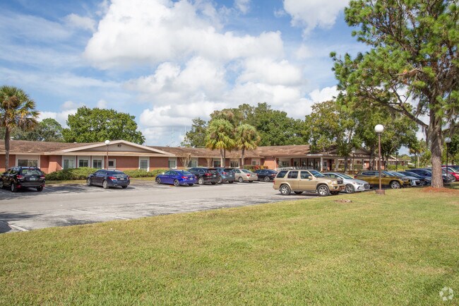
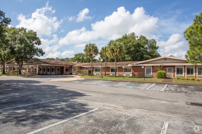
4927 Voorhees Rd
Tampa-St. Petersburg-Clearwater, FL
Tampa & Tarpon Springs Land Co Sub
16-26-16-0010-00500-0020
TAMPA-TARPON SPRINGS LAND COMPANY SUBDIVISION PB 1 PGS 69 & 70 ELY 150.00 FT OF NLY 185.00 FT OF TRACT 5 LESS NORTH 30.00 FT & EAST 25.00 FT THEREOF FOR RD R/W
Hospitalprivate
Pasco
X
Florida
12101C0352G
1
2024
4.67 AC
2025
Pasco County
031412
Tampa/St Petersburg
49,753 SF
DEMOGRAPHICS near 4927 Voorhees Rd
1 Mile
3 Mile
5 Mile
2024 Total Population
11,838
91,244
184,681
2029 Population
14,202
109,743
221,900
Pop Growth 2024-2029
+ 19.97%
+ 20.27%
+ 20.15%
Average Age
45
45
44
2024 Total Households
5,106
40,419
79,071
HH Growth 2024-2029
+ 19.96%
+ 20.27%
+ 20.22%
Median Household Inc
$43,907
$47,477
$49,092
Avg Household Size
2.20
2.20
2.30
2024 Avg HH Vehicles
1.00
2.00
2.00
Median Home Value
$135,594
$174,456
$186,239
Median Year Built
1979
1979
1980
Nearby Places
Map Layers
Map Styles
 Street
 Aerial
- Restaurants
- Banks
- Shops
- Fitness
- Groceries
PUBLIC TRANSPORTATION
AIRPORT
St Pete-Clearwater International
DRIVE
WALK
Distance
St Pete-Clearwater International
42 min
24.6 mi
Tampa International
DRIVE
WALK
Distance
Tampa International
48 min
31.9 mi
Freight Ports
Port of Tampa Bay
DRIVE
WALK
Distance
Port of Tampa Bay
61 min
37.4 mi
Nearby Properties
Address
Land Use
TOTAL SIZE
Lot Size
Zoning
Address
Land Use
TOTAL SIZE
Lot Size
Zoning
384,700 SF
18.90 AC
MF3
Address
Land Use
TOTAL SIZE
Lot Size
Zoning
799,241 SF
88.92 AC
PUD
Address
Land Use
TOTAL SIZE
Lot Size
Zoning
203,571 SF
13.82 AC
C2
Address
Land Use
TOTAL SIZE
Lot Size
Zoning
248,561 SF
14.17 AC
C
Address
Land Use
TOTAL SIZE
Lot Size
Zoning
241,429 SF
37.59 AC
C
Address
Land Use
TOTAL SIZE
Lot Size
Zoning
229,050 SF
36.13 AC
MPUD
Address
Land Use
TOTAL SIZE
Lot Size
Zoning
113,034 SF
15.21 AC
MPUD
Address
Land Use
TOTAL SIZE
Lot Size
Zoning
162,716 SF
16.56 AC
MF1
Address
Land Use
TOTAL SIZE
Lot Size
Zoning
171,378 SF
17.35 AC
MF1
Address
Land Use
TOTAL SIZE
Lot Size
Zoning
149,162 SF
3.10 AC
C
Address
Land Use
TOTAL SIZE
Lot Size
Zoning
193,971 SF
4.50 AC
C1
Address
Land Use
TOTAL SIZE
Lot Size
Zoning
191,812 SF
17.61 AC
MPUD
Address
Land Use
TOTAL SIZE
Lot Size
Zoning
114,831 SF
7.98 AC
MF2
Address
Land Use
TOTAL SIZE
Lot Size
Zoning
163,106 SF
13.97 AC
C
Address
Land Use
TOTAL SIZE
Lot Size
Zoning
91,660 SF
16.29 AC
C
Address
Land Use
TOTAL SIZE
Lot Size
Zoning
135,600 SF
13.34 AC
MF1
Address
Land Use
TOTAL SIZE
Lot Size
Zoning
217,376 SF
22.12 AC
C2
Address
Land Use
TOTAL SIZE
Lot Size
Zoning
43,469 SF
11.48 AC
MPUD
Address
Land Use
TOTAL SIZE
Lot Size
Zoning
112,703 SF
8.43 AC
C2
Address
Land Use
TOTAL SIZE
Lot Size
Zoning
16,510 SF
41.69 AC
R1
Address
Land Use
TOTAL SIZE
Lot Size
Zoning
77,900 SF
10.52 AC
C2
Address
Land Use
TOTAL SIZE
Lot Size
Zoning
142,856 SF
20 AC
C
Address
Land Use
TOTAL SIZE
Lot Size
Zoning
82,047 SF
21.48 AC
MF2
Address
Land Use
TOTAL SIZE
Lot Size
Zoning
93,304 SF
18.82 AC
MF1
Address
Land Use
TOTAL SIZE
Lot Size
Zoning
133,304 SF
13.48 AC
C2
Address
Land Use
TOTAL SIZE
Lot Size
Zoning
76,160 SF
6.74 AC
MPUD
Address
Land Use
TOTAL SIZE
Lot Size
Zoning
81,272 SF
47.25 AC
MF2
Address
Land Use
TOTAL SIZE
Lot Size
Zoning
53,055 SF
5.71 AC
C2
Address
Land Use
TOTAL SIZE
Lot Size
Zoning
22,216 SF
7.20 AC
C2
The World's #1 Commercial Real Estate Marketplace
Connect with us
© 2025 CoStar Group
The information above has been obtained from sources believed reliable. While we do not doubt its accuracy we have not verified it and make no guarantee, warranty or representation about it. It is your responsibility to independently confirm its accuracy and completeness. Any projections, opinions, assumptions, or estimates used are for example only and do not represent the current or future performance of the property. The value of this transaction to you depends on tax and other factors which should be evaluated by your tax, financial, and legal advisors. You and your advisors should conduct a careful, independent investigation of the property to determine to your satisfaction the suitability of the property for your needs.