Property Record
4929 Mobile Hwy, Pensacola, FL 32506


NEARBY LISTINGS FOR SALE OR LEASE
Property Detail
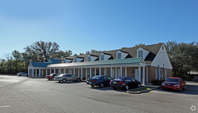
4929 Mobile Hwy
Pensacola-Ferry Pass-Brent, FL
Pensacola Home Orchards Plat
14-2S-30-2001-351-006
SLY 35 3/10 FT LT 34 ALL LTS 35 36 37 & NWLY 31 2/10 FT LT 38 BLK 6 PENSACOLA HOME ORCHARDS S/D PLAT DB 87 P 524 OR 9259 P 137 LESS DB 508 P 519 RD R/W
Officebuilding
Escambia
X
Florida
12033C0360G
351
2024
1.84 AC
2025
Myrtle Grove/Bellview
003002
Pensacola
7,104 SF
DEMOGRAPHICS near 4929 Mobile Hwy
1 Mile
3 Mile
5 Mile
2024 Total Population
7,868
69,166
139,244
2029 Population
8,014
70,573
142,528
Pop Growth 2024-2029
+ 1.86%
+ 2.03%
+ 2.36%
Average Age
36
38
38
2024 Total Households
2,979
26,769
54,019
HH Growth 2024-2029
+ 1.81%
+ 1.97%
+ 2.43%
Median Household Inc
$46,527
$44,081
$43,313
Avg Household Size
2.60
2.40
2.30
2024 Avg HH Vehicles
2.00
2.00
2.00
Median Home Value
$95,308
$126,128
$151,442
Median Year Built
1973
1975
1974
Nearby Places
Map Layers
Map Styles
 Street
 Aerial
- Restaurants
- Banks
- Shops
- Fitness
- Groceries
PUBLIC TRANSPORTATION
AIRPORT
Pensacola International
DRIVE
WALK
Distance
Pensacola International
17 min
7.3 mi
Freight Ports
Port of Mobile
DRIVE
WALK
Distance
Port of Mobile
66 min
54.0 mi
SALE & LEASE HISTORY
LISTING DATE
SALE/LEASE

Dec 12, 2022
For Sale
Nearby Properties
Address
Land Use
TOTAL SIZE
Lot Size
Zoning
Address
Land Use
TOTAL SIZE
Lot Size
Zoning
305,650 SF
21.90 AC
HDMU
Address
Land Use
TOTAL SIZE
Lot Size
Zoning
289,397 SF
12.38 AC
PUB
Address
Land Use
TOTAL SIZE
Lot Size
Zoning
250,232 SF
19.24 AC
HDR
Address
Land Use
TOTAL SIZE
Lot Size
Zoning
334,324 SF
55.06 AC
PUB
Address
Land Use
TOTAL SIZE
Lot Size
Zoning
282,738 SF
14.64 AC
PUB
Address
Land Use
TOTAL SIZE
Lot Size
Zoning
169,963 SF
15.43 AC
HC/LI
Address
Land Use
TOTAL SIZE
Lot Size
Zoning
169,346 SF
15.21 AC
HDR
Address
Land Use
TOTAL SIZE
Lot Size
Zoning
158,233 SF
9.15 AC
HDMU
Address
Land Use
TOTAL SIZE
Lot Size
Zoning
83,923 SF
6.70 AC
HC/LI
Address
Land Use
TOTAL SIZE
Lot Size
Zoning
99,147 SF
5.89 AC
HDMU
Address
Land Use
TOTAL SIZE
Lot Size
Zoning
116,020 SF
4.71 AC
MDR
Address
Land Use
TOTAL SIZE
Lot Size
Zoning
197,958 SF
26.08 AC
COM
Address
Land Use
TOTAL SIZE
Lot Size
Zoning
184,232 SF
11.32 AC
HC/LI
Address
Land Use
TOTAL SIZE
Lot Size
Zoning
129,532 SF
10.84 AC
COM
Address
Land Use
TOTAL SIZE
Lot Size
Zoning
103,671 SF
13.96 AC
HDMU
Address
Land Use
TOTAL SIZE
Lot Size
Zoning
138,048 SF
22.64 AC
HC/LI
Address
Land Use
TOTAL SIZE
Lot Size
Zoning
138,840 SF
4.52 AC
HC/LI,HDMU
Address
Land Use
TOTAL SIZE
Lot Size
Zoning
137,280 SF
11.94 AC
HC/LI
Address
Land Use
TOTAL SIZE
Lot Size
Zoning
124,146 SF
5.79 AC
HDMU
Address
Land Use
TOTAL SIZE
Lot Size
Zoning
371,425 SF
24.78 AC
HC/LI
Address
Land Use
TOTAL SIZE
Lot Size
Zoning
223,987 SF
36.60 AC
MDR
Address
Land Use
TOTAL SIZE
Lot Size
Zoning
401,493 SF
26.61 AC
HC/LI
Address
Land Use
TOTAL SIZE
Lot Size
Zoning
81,874 SF
7.09 AC
HDMU
Address
Land Use
TOTAL SIZE
Lot Size
Zoning
74,964 SF
5.72 AC
HDMU
Address
Land Use
TOTAL SIZE
Lot Size
Zoning
77,074 SF
5.79 AC
HC/LI
Address
Land Use
TOTAL SIZE
Lot Size
Zoning
3,926 SF
57.46 AC
HDMU
Address
Land Use
TOTAL SIZE
Lot Size
Zoning
64,870 SF
5.35 AC
HDMU
Address
Land Use
TOTAL SIZE
Lot Size
Zoning
84,005 SF
7.93 AC
COM
Address
Land Use
TOTAL SIZE
Lot Size
Zoning
100,476 SF
3.74 AC
COM,HC/LI
Address
Land Use
TOTAL SIZE
Lot Size
Zoning
65,355 SF
6.27 AC
COM
The World's #1 Commercial Real Estate Marketplace
Connect with us
© 2026 CoStar Group
The information above has been obtained from sources believed reliable. While we do not doubt its accuracy we have not verified it and make no guarantee, warranty or representation about it. It is your responsibility to independently confirm its accuracy and completeness. Any projections, opinions, assumptions, or estimates used are for example only and do not represent the current or future performance of the property. The value of this transaction to you depends on tax and other factors which should be evaluated by your tax, financial, and legal advisors. You and your advisors should conduct a careful, independent investigation of the property to determine to your satisfaction the suitability of the property for your needs.