Property Record
493 E Bay Ave, Barnegat, NJ 08005
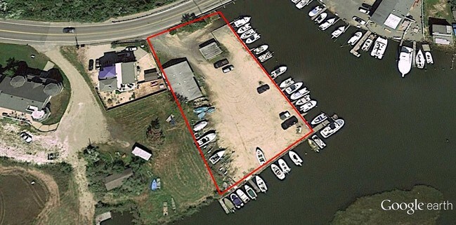

Property Detail
493 E Bay Ave
01-00262-0000-00008
100 X 200 MARINA/STORE
Commercialnec
Ocean
CM
New Jersey
AE The base floodplain where base flood elevations are provided. AE Zones are now used on new format FIRMs instead of A1-A30 Zones.
8
2025
0.46 AC
2025
Ocean County
734002
Northern New Jersey
1,652 SF
Lakewood-New Brunswick, NJ
NEARBY LISTINGS FOR SALE OR LEASE
-
-
View all Barnegat listings for sale on LoopNet.com
DEMOGRAPHICS near 493 E Bay Ave
1 mile
3 mile
5 mile
2025 Total Population
945
20,232
54,722
2030 Population
1,006
20,756
57,031
Pop Growth 2025-2030
+ 6.46%
+ 2.59%
+ 4.22%
Average Age
41
40
44
2025 Total Households
382
7,362
21,212
HH Growth 2025-2030
+ 6.02%
+ 2.17%
+ 4.03%
Median Household Inc
$90,548
$97,873
$102,422
Avg Household Size
2.40
2.60
2.50
2025 Avg HH Vehicles
2.00
2.00
2.00
Median Home Value
$328,723
$405,255
$427,613
Median Year Built
1977
1984
1991
Nearby Places
Map Layers
Map Styles
 Street
 Aerial
Transit
 Traffic
 Biking
Places
Listings with unknown addresses are not visible on the map
- Restaurants
- Banks
- Shops
- Fitness
- Groceries
PUBLIC TRANSPORTATION
AIRPORT
Atlantic City International
Drive
Walk
Distance
Atlantic City International
67 min
36.2 mi
Freight Ports
Port of Philadelphia
Drive
Walk
Distance
Port of Philadelphia
71 min
55.0 mi
SALE & LEASE HISTORY
LISTING DATE
SALE/LEASE

Apr 13, 2017
For Sale
Nearby Properties
Address
Land Use
TOTAL SIZE
Lot Size
Zoning
Address
Land Use
TOTAL SIZE
Lot Size
Zoning
85.65 AC
R40
Address
Land Use
TOTAL SIZE
Lot Size
Zoning
46.40 AC
ML-4
Address
Land Use
TOTAL SIZE
Lot Size
Zoning
85.65 AC
R40
Address
Land Use
TOTAL SIZE
Lot Size
Zoning
7.49 AC
R20
Address
Land Use
TOTAL SIZE
Lot Size
Zoning
15.12 AC
R-2
Address
Land Use
TOTAL SIZE
Lot Size
Zoning
6,600 SF
10.67 AC
PRD
Address
Land Use
TOTAL SIZE
Lot Size
Zoning
67,548 SF
10.98 AC
CN
Address
Land Use
TOTAL SIZE
Lot Size
Zoning
86,000 SF
2.87 AC
R20
Address
Land Use
TOTAL SIZE
Lot Size
Zoning
23.70 AC
BCWD
Address
Land Use
TOTAL SIZE
Lot Size
Zoning
89.90 AC
R-2
Address
Land Use
TOTAL SIZE
Lot Size
Zoning
56.23 AC
BC
Address
Land Use
TOTAL SIZE
Lot Size
Zoning
11,695 SF
9.31 AC
R20
Address
Land Use
TOTAL SIZE
Lot Size
Zoning
4,230 SF
10.65 AC
CPHD
Address
Land Use
TOTAL SIZE
Lot Size
Zoning
4.85 AC
CPHD
Address
Land Use
TOTAL SIZE
Lot Size
Zoning
398 AC
PW
Address
Land Use
TOTAL SIZE
Lot Size
Zoning
3.34 AC
C-1
Address
Land Use
TOTAL SIZE
Lot Size
Zoning
5.14 AC
CPHD
Address
Land Use
TOTAL SIZE
Lot Size
Zoning
58,375 SF
5.46 AC
CPHD
Address
Land Use
TOTAL SIZE
Lot Size
Zoning
37,476 SF
14.66 AC
R6
Address
Land Use
TOTAL SIZE
Lot Size
Zoning
11.91 AC
RA
Address
Land Use
TOTAL SIZE
Lot Size
Zoning
52,212 SF
4.41 AC
TCCN
Address
Land Use
TOTAL SIZE
Lot Size
Zoning
31,658 SF
5.88 AC
TCCN
Address
Land Use
TOTAL SIZE
Lot Size
Zoning
6.39 AC
ML-1
Address
Land Use
TOTAL SIZE
Lot Size
Zoning
6.03 AC
MU
Address
Land Use
TOTAL SIZE
Lot Size
Zoning
5,430 SF
2.15 AC
CN
Address
Land Use
TOTAL SIZE
Lot Size
Zoning
4.70 AC
ML5
Address
Land Use
TOTAL SIZE
Lot Size
Zoning
13,041 SF
1.18 AC
TCCN
Address
Land Use
TOTAL SIZE
Lot Size
Zoning
256 SF
1.61 AC
CM
Address
Land Use
TOTAL SIZE
Lot Size
Zoning
23,200 SF
2.98 AC
C-1
Address
Land Use
TOTAL SIZE
Lot Size
Zoning
5,280 SF
6.88 AC
TCCN
The World's #1 Commercial Real Estate Marketplace
Connect with us
© 2026 CoStar Group
The information above has been obtained from sources believed reliable. While we do not doubt its accuracy we have not verified it and make no guarantee, warranty or representation about it. It is your responsibility to independently confirm its accuracy and completeness. Any projections, opinions, assumptions, or estimates used are for example only and do not represent the current or future performance of the property. The value of this transaction to you depends on tax and other factors which should be evaluated by your tax, financial, and legal advisors. You and your advisors should conduct a careful, independent investigation of the property to determine to your satisfaction the suitability of the property for your needs.