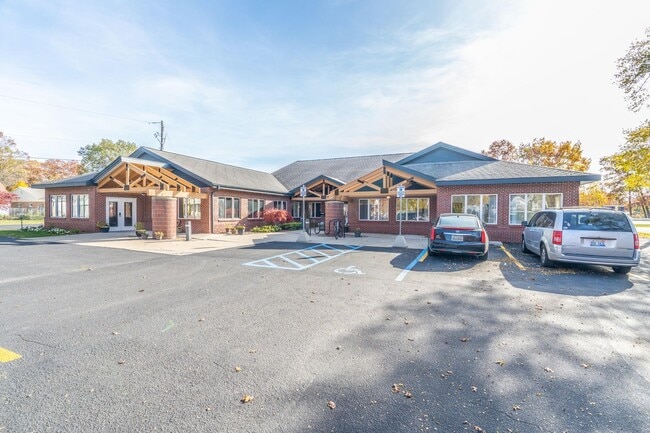
Property Record
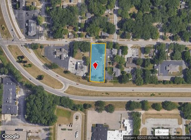
493 W Norton Ave, Norton Shores, MI 49444
NEARBY LISTINGS FOR SALE OR LEASE
Property Detail
493 W Norton Ave
27-107-100-0009-00
Orth
Commercialnec
CITY OF NORTON SHORES ALL THAT PART OF THE SOUTH 160 FEET OF THE NORTH 378 FEET OF THE WEST 132 FEET OF THE EAST 495 FEET OF
X
Muskegon
26121C0259E
Michigan
2024
0.95 AC
2025
Muskegon Heights
002400
West Michigan
11,140 SF
Muskegon, MI
DEMOGRAPHICS near 493 W Norton Ave
1 Mile
3 Mile
5 Mile
2024 Total Population
8,415
59,088
95,634
2029 Population
8,539
59,661
96,468
Pop Growth 2024-2029
+ 1.47%
+ 0.97%
+ 0.87%
Average Age
39
40
40
2024 Total Households
3,626
22,784
37,901
HH Growth 2024-2029
+ 1.38%
+ 0.92%
+ 0.86%
Median Household Inc
$48,150
$48,247
$49,762
Avg Household Size
2.20
2.30
2.30
2024 Avg HH Vehicles
2.00
2.00
2.00
Median Home Value
$110,365
$134,649
$144,612
Median Year Built
1958
1956
1960
Nearby Places
Map Layers
Map Styles
 Street
 Aerial
- Restaurants
- Banks
- Shops
- Fitness
- Groceries
SALE & LEASE HISTORY
LISTING DATE
SALE/LEASE

Sep 24, 2024
For Lease
Oct 13, 2021
For Sale
Jan 11, 2023
For Lease
Dec 18, 2020
For Sale
Nearby Properties
Address
Land Use
TOTAL SIZE
Lot Size
Zoning
Address
Land Use
TOTAL SIZE
Lot Size
Zoning
82,643 SF
5.20 AC
MC
Address
Land Use
TOTAL SIZE
Lot Size
Zoning
6,900 SF
165.61 AC
GI
Address
Land Use
TOTAL SIZE
Lot Size
Zoning
84,452 SF
6.82 AC
PUD
Address
Land Use
TOTAL SIZE
Lot Size
Zoning
249,032 SF
19.18 AC
MFR
Address
Land Use
TOTAL SIZE
Lot Size
Zoning
41,382 SF
6.20 AC
PUD
Address
Land Use
TOTAL SIZE
Lot Size
Zoning
187,210 SF
23.22 AC
GI
Address
Land Use
TOTAL SIZE
Lot Size
Zoning
219,341 SF
18.55 AC
C-SE
Address
Land Use
TOTAL SIZE
Lot Size
Zoning
80,572 SF
12.98 AC
I-1
Address
Land Use
TOTAL SIZE
Lot Size
Zoning
194,708 SF
15.59 AC
C-2
Address
Land Use
TOTAL SIZE
Lot Size
Zoning
19,171 SF
6.55 AC
MC
Address
Land Use
TOTAL SIZE
Lot Size
Zoning
350,378 SF
21.50 AC
GI
Address
Land Use
TOTAL SIZE
Lot Size
Zoning
184,786 SF
24.10 AC
SUD
Address
Land Use
TOTAL SIZE
Lot Size
Zoning
82,895 SF
13.09 AC
SC-1
Address
Land Use
TOTAL SIZE
Lot Size
Zoning
85,577 SF
8.72 AC
PUD
Address
Land Use
TOTAL SIZE
Lot Size
Zoning
68,782 SF
10.52 AC
C-2
Address
Land Use
TOTAL SIZE
Lot Size
Zoning
121,466 SF
11.65 AC
SC-1
Address
Land Use
TOTAL SIZE
Lot Size
Zoning
122.75 AC
R-2
Address
Land Use
TOTAL SIZE
Lot Size
Zoning
124,416 SF
7.41 AC
MFR
Address
Land Use
TOTAL SIZE
Lot Size
Zoning
60,658 SF
4.42 AC
RM-2
Address
Land Use
TOTAL SIZE
Lot Size
Zoning
80,572 SF
12.98 AC
I-1
Address
Land Use
TOTAL SIZE
Lot Size
Zoning
17,461 SF
2.72 AC
MC
Address
Land Use
TOTAL SIZE
Lot Size
Zoning
125,478 SF
7.90 AC
WM
Address
Land Use
TOTAL SIZE
Lot Size
Zoning
110,460 SF
12.26 AC
AR-8
Address
Land Use
TOTAL SIZE
Lot Size
Zoning
212,648 SF
9.20 AC
B-2, PUD
Address
Land Use
TOTAL SIZE
Lot Size
Zoning
399,872 SF
16.99 AC
I-2
Address
Land Use
TOTAL SIZE
Lot Size
Zoning
32,811 SF
5.87 AC
B-4
Address
Land Use
TOTAL SIZE
Lot Size
Zoning
121,766 SF
10.29 AC
C-NE
Address
Land Use
TOTAL SIZE
Lot Size
Zoning
123,081 SF
8.50 AC
B-4
Address
Land Use
TOTAL SIZE
Lot Size
Zoning
224,070 SF
15.85 AC
GI
Address
Land Use
TOTAL SIZE
Lot Size
Zoning
79,792 SF
4.94 AC
PUD
The World's #1 Commercial Real Estate Marketplace
Connect with us
© 2025 CoStar Group
The information above has been obtained from sources believed reliable. While we do not doubt its accuracy we have not verified it and make no guarantee, warranty or representation about it. It is your responsibility to independently confirm its accuracy and completeness. Any projections, opinions, assumptions, or estimates used are for example only and do not represent the current or future performance of the property. The value of this transaction to you depends on tax and other factors which should be evaluated by your tax, financial, and legal advisors. You and your advisors should conduct a careful, independent investigation of the property to determine to your satisfaction the suitability of the property for your needs.