Property Record
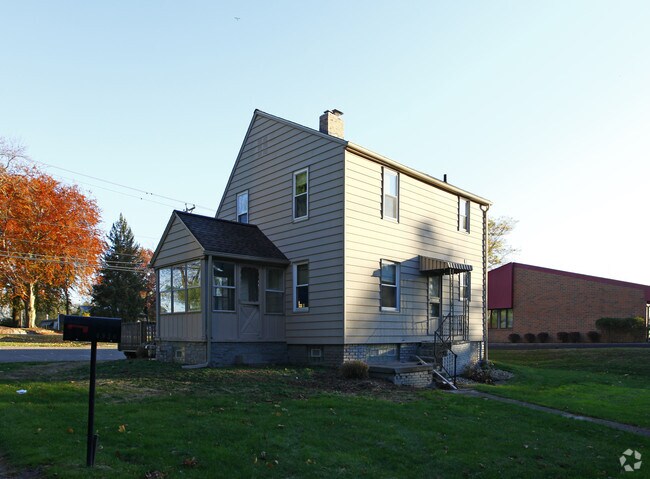
4930 Hills And Dales Rd Nw, Canton, OH 44708


NEARBY LISTINGS FOR SALE OR LEASE
Property Detail
4930 Hills And Dales Rd Nw
01700124
36 NW .25A
Officebuilding
Stark
X
Ohio
39151C0204E
0.25 AC
0
Stark County
2025
Cleveland
711501
Canton-Massillon, OH
1,223 SF
DEMOGRAPHICS near 4930 Hills And Dales Rd Nw
1 Mile
3 Mile
5 Mile
2024 Total Population
4,154
60,718
169,235
2029 Population
4,156
60,172
167,972
Pop Growth 2024-2029
+ 0.05%
(0.90%)
(0.75%)
Average Age
51
43
42
2024 Total Households
2,293
27,422
73,151
HH Growth 2024-2029
+ 0.22%
(0.85%)
(0.76%)
Median Household Inc
$53,455
$57,890
$54,784
Avg Household Size
1.80
2.20
2.20
2024 Avg HH Vehicles
2.00
2.00
2.00
Median Home Value
$202,805
$163,254
$155,313
Median Year Built
1977
1965
1962
Nearby Places
Map Layers
Map Styles
 Street
 Aerial
- Restaurants
- Banks
- Shops
- Fitness
- Groceries
PUBLIC TRANSPORTATION
AIRPORT
Akron-Canton Regional
DRIVE
WALK
Distance
Akron-Canton Regional
14 min
7.5 mi
SALE & LEASE HISTORY
LISTING DATE
SALE/LEASE

Feb 15, 2019
For Sale
Nearby Properties
Address
Land Use
TOTAL SIZE
Lot Size
Zoning
Address
Land Use
TOTAL SIZE
Lot Size
Zoning
86,994 SF
35.20 AC
Address
Land Use
TOTAL SIZE
Lot Size
Zoning
234,168 SF
22.77 AC
Address
Land Use
TOTAL SIZE
Lot Size
Zoning
475,122 SF
81.74 AC
Address
Land Use
TOTAL SIZE
Lot Size
Zoning
494,965 SF
15.48 AC
Address
Land Use
TOTAL SIZE
Lot Size
Zoning
194,249 SF
10.90 AC
Address
Land Use
TOTAL SIZE
Lot Size
Zoning
390,841 SF
19 AC
Address
Land Use
TOTAL SIZE
Lot Size
Zoning
367,640 SF
35.46 AC
Address
Land Use
TOTAL SIZE
Lot Size
Zoning
330,693 SF
14.29 AC
Address
Land Use
TOTAL SIZE
Lot Size
Zoning
180,000 SF
Address
Land Use
TOTAL SIZE
Lot Size
Zoning
147,708 SF
4.76 AC
Address
Land Use
TOTAL SIZE
Lot Size
Zoning
234,168 SF
22.17 AC
Address
Land Use
TOTAL SIZE
Lot Size
Zoning
294,409 SF
18.85 AC
Address
Land Use
TOTAL SIZE
Lot Size
Zoning
194,249 SF
10.86 AC
Address
Land Use
TOTAL SIZE
Lot Size
Zoning
168,731 SF
57.06 AC
Address
Land Use
TOTAL SIZE
Lot Size
Zoning
108,197 SF
8.19 AC
Address
Land Use
TOTAL SIZE
Lot Size
Zoning
8,704 SF
Address
Land Use
TOTAL SIZE
Lot Size
Zoning
171,663 SF
16.77 AC
Address
Land Use
TOTAL SIZE
Lot Size
Zoning
96,596 SF
18.44 AC
Address
Land Use
TOTAL SIZE
Lot Size
Zoning
151,342 SF
14.49 AC
Address
Land Use
TOTAL SIZE
Lot Size
Zoning
117,601 SF
7.93 AC
Address
Land Use
TOTAL SIZE
Lot Size
Zoning
124,918 SF
12.85 AC
Address
Land Use
TOTAL SIZE
Lot Size
Zoning
80,416 SF
81.53 AC
Address
Land Use
TOTAL SIZE
Lot Size
Zoning
143,920 SF
18.49 AC
Address
Land Use
TOTAL SIZE
Lot Size
Zoning
106,416 SF
18.99 AC
Address
Land Use
TOTAL SIZE
Lot Size
Zoning
300,347 SF
14.78 AC
Address
Land Use
TOTAL SIZE
Lot Size
Zoning
61,884 SF
2.18 AC
Address
Land Use
TOTAL SIZE
Lot Size
Zoning
93,216 SF
4.93 AC
Address
Land Use
TOTAL SIZE
Lot Size
Zoning
96,710 SF
4.59 AC
Address
Land Use
TOTAL SIZE
Lot Size
Zoning
36,991 SF
2.62 AC
Address
Land Use
TOTAL SIZE
Lot Size
Zoning
89,344 SF
3.77 AC
The World's #1 Commercial Real Estate Marketplace
Connect with us
© 2026 CoStar Group
The information above has been obtained from sources believed reliable. While we do not doubt its accuracy we have not verified it and make no guarantee, warranty or representation about it. It is your responsibility to independently confirm its accuracy and completeness. Any projections, opinions, assumptions, or estimates used are for example only and do not represent the current or future performance of the property. The value of this transaction to you depends on tax and other factors which should be evaluated by your tax, financial, and legal advisors. You and your advisors should conduct a careful, independent investigation of the property to determine to your satisfaction the suitability of the property for your needs.