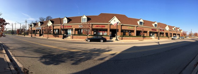
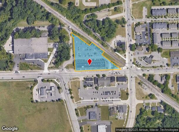
Property Record
49342 Pontiac Trl, Wixom, MI 48393
NEARBY LISTINGS FOR SALE OR LEASE
Property Detail
49342 Pontiac Trl
Detroit-Warren-Dearborn, MI
Supervisor
17-31-478-007
T2N, R8E, SEC 31 SUPERVISOR'S PLAT NO 10 LOTS 7 THRU 11 INCL EXC PART OF LOT 7 DESC AS BEG AT NW COR OF SD LOT 7, TH ALG
Regionalshoppingcenterormallwithanchorstore
Oakland
X
Michigan
26125C0468F
7-11
2024
2.10 AC
2024
Central I-96 Corridor
133001
Detroit
16,800 SF
DEMOGRAPHICS near 49342 Pontiac Trl
1 Mile
3 Mile
5 Mile
2024 Total Population
7,375
38,653
101,154
2029 Population
7,011
37,849
100,066
Pop Growth 2024-2029
(4.94%)
(2.08%)
(1.08%)
Average Age
37
39
41
2024 Total Households
4,107
17,169
41,971
HH Growth 2024-2029
(5.55%)
(2.50%)
(1.27%)
Median Household Inc
$48,015
$73,188
$90,810
Avg Household Size
1.80
2.20
2.40
2024 Avg HH Vehicles
1.00
2.00
2.00
Median Home Value
$290,624
$311,480
$352,887
Median Year Built
1983
1990
1992
Nearby Places
Map Layers
Map Styles
 Street
 Aerial
- Restaurants
- Banks
- Shops
- Fitness
- Groceries
PUBLIC TRANSPORTATION
AIRPORT
Detroit Metro Wayne County
DRIVE
WALK
Distance
Detroit Metro Wayne County
32 min
32.0 mi
Detroit City
DRIVE
WALK
Distance
Detroit City
40 min
32.7 mi
Freight Ports
Port of Baltimore
DRIVE
WALK
Distance
Port of Baltimore
1 min
426.6 mi
SALE & LEASE HISTORY
LISTING DATE
SALE/LEASE

Sep 25, 2016
For Lease
Sep 13, 2017
For Lease
Mar 08, 2017
For Lease
Jun 05, 2019
For Lease
Jan 16, 2025
For Lease
Nearby Properties
Address
Land Use
TOTAL SIZE
Lot Size
Zoning
Address
Land Use
TOTAL SIZE
Lot Size
Zoning
873,288 SF
Address
Land Use
TOTAL SIZE
Lot Size
Zoning
72.63 AC
RM-1
Address
Land Use
TOTAL SIZE
Lot Size
Zoning
86.19 AC
RC2
Address
Land Use
TOTAL SIZE
Lot Size
Zoning
563,160 SF
47.06 AC
Address
Land Use
TOTAL SIZE
Lot Size
Zoning
12,872 SF
43.06 AC
RM-1
Address
Land Use
TOTAL SIZE
Lot Size
Zoning
59.71 AC
RM-1
Address
Land Use
TOTAL SIZE
Lot Size
Zoning
144.50 AC
OSC
Address
Land Use
TOTAL SIZE
Lot Size
Zoning
184,225 SF
13.84 AC
OSC
Address
Land Use
TOTAL SIZE
Lot Size
Zoning
38.85 AC
RC2
Address
Land Use
TOTAL SIZE
Lot Size
Zoning
Address
Land Use
TOTAL SIZE
Lot Size
Zoning
140,366 SF
30.67 AC
II
Address
Land Use
TOTAL SIZE
Lot Size
Zoning
172,700 SF
Address
Land Use
TOTAL SIZE
Lot Size
Zoning
4,140 SF
120 AC
MM
Address
Land Use
TOTAL SIZE
Lot Size
Zoning
126,720 SF
8.31 AC
Address
Land Use
TOTAL SIZE
Lot Size
Zoning
7,471 SF
114.63 AC
MM
Address
Land Use
TOTAL SIZE
Lot Size
Zoning
325,725 SF
30.46 AC
Address
Land Use
TOTAL SIZE
Lot Size
Zoning
25.58 AC
RC1
Address
Land Use
TOTAL SIZE
Lot Size
Zoning
279,807 SF
31.24 AC
II
Address
Land Use
TOTAL SIZE
Lot Size
Zoning
26.54 AC
RM-1
Address
Land Use
TOTAL SIZE
Lot Size
Zoning
200,926 SF
30.87 AC
M1
Address
Land Use
TOTAL SIZE
Lot Size
Zoning
208,276 SF
28.02 AC
Address
Land Use
TOTAL SIZE
Lot Size
Zoning
101,752 SF
7.20 AC
Address
Land Use
TOTAL SIZE
Lot Size
Zoning
14.93 AC
RC2
Address
Land Use
TOTAL SIZE
Lot Size
Zoning
Address
Land Use
TOTAL SIZE
Lot Size
Zoning
150,217 SF
10.22 AC
IV
Address
Land Use
TOTAL SIZE
Lot Size
Zoning
233,158 SF
24.50 AC
Address
Land Use
TOTAL SIZE
Lot Size
Zoning
132,101 SF
Address
Land Use
TOTAL SIZE
Lot Size
Zoning
20.33 AC
RM-1
Address
Land Use
TOTAL SIZE
Lot Size
Zoning
2,980 SF
71.92 AC
MH
Address
Land Use
TOTAL SIZE
Lot Size
Zoning
148,298 SF
20.43 AC
The World's #1 Commercial Real Estate Marketplace
Connect with us
© 2025 CoStar Group
The information above has been obtained from sources believed reliable. While we do not doubt its accuracy we have not verified it and make no guarantee, warranty or representation about it. It is your responsibility to independently confirm its accuracy and completeness. Any projections, opinions, assumptions, or estimates used are for example only and do not represent the current or future performance of the property. The value of this transaction to you depends on tax and other factors which should be evaluated by your tax, financial, and legal advisors. You and your advisors should conduct a careful, independent investigation of the property to determine to your satisfaction the suitability of the property for your needs.