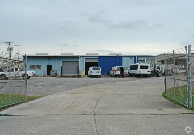
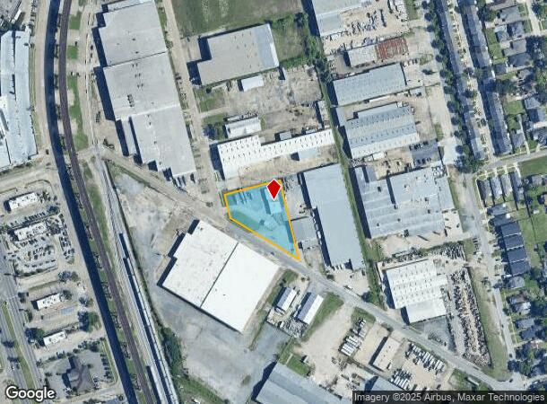
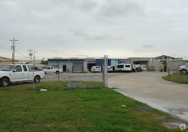
Property Record
4935 Bloomfield St, New Orleans, LA 70121
NEARBY LISTINGS FOR SALE OR LEASE
Property Detail
4935 Bloomfield St
New Orleans-Metairie, LA
New Orleans Public Belt R.R
0700001988
LOT 1-C-1-AA-1-B N O PUBLIC BELT RR MAP 12952
Realpropertynec
Jefferson
AE
Louisiana
22051C0185F
1c1a
2024
0.99 AC
2024
Elmwood/Harahan
024300
New Orleans/Metairie/Kenner
DEMOGRAPHICS near 4935 Bloomfield St
1 Mile
3 Mile
5 Mile
2024 Total Population
8,417
98,538
279,580
2029 Population
8,146
94,728
268,797
Pop Growth 2024-2029
(3.22%)
(3.87%)
(3.86%)
Average Age
43
42
41
2024 Total Households
4,337
44,589
119,297
HH Growth 2024-2029
(3.34%)
(4.01%)
(4.04%)
Median Household Inc
$65,043
$61,098
$61,393
Avg Household Size
1.90
2.20
2.20
2024 Avg HH Vehicles
1.00
2.00
2.00
Median Home Value
$234,515
$264,872
$279,765
Median Year Built
1973
1969
1966
Nearby Places
Map Layers
Map Styles
 Street
 Aerial
- Restaurants
- Banks
- Shops
- Fitness
- Groceries
PUBLIC TRANSPORTATION
COMMUTER RAIL
DRIVE
WALK
Distance
16 min
7.8 mi
AIRPORT
Louis Armstrong New Orleans International
DRIVE
WALK
Distance
Louis Armstrong New Orleans International
18 min
9.6 mi
Freight Ports
Port of New Orleans
DRIVE
WALK
Distance
Port of New Orleans
22 min
10.3 mi
Nearby Properties
Address
Land Use
TOTAL SIZE
Lot Size
Zoning
Address
Land Use
TOTAL SIZE
Lot Size
Zoning
22.63 AC
Address
Land Use
TOTAL SIZE
Lot Size
Zoning
0.14 AC
Address
Land Use
TOTAL SIZE
Lot Size
Zoning
35.06 AC
Address
Land Use
TOTAL SIZE
Lot Size
Zoning
4.31 AC
BC2
Address
Land Use
TOTAL SIZE
Lot Size
Zoning
42.34 AC
Address
Land Use
TOTAL SIZE
Lot Size
Zoning
0.08 AC
Address
Land Use
TOTAL SIZE
Lot Size
Zoning
Address
Land Use
TOTAL SIZE
Lot Size
Zoning
Address
Land Use
TOTAL SIZE
Lot Size
Zoning
7.98 AC
R1A
Address
Land Use
TOTAL SIZE
Lot Size
Zoning
Address
Land Use
TOTAL SIZE
Lot Size
Zoning
66.02 AC
Address
Land Use
TOTAL SIZE
Lot Size
Zoning
Address
Land Use
TOTAL SIZE
Lot Size
Zoning
Address
Land Use
TOTAL SIZE
Lot Size
Zoning
Address
Land Use
TOTAL SIZE
Lot Size
Zoning
0.69 AC
Address
Land Use
TOTAL SIZE
Lot Size
Zoning
0.25 AC
Address
Land Use
TOTAL SIZE
Lot Size
Zoning
14.56 AC
R1A
Address
Land Use
TOTAL SIZE
Lot Size
Zoning
Address
Land Use
TOTAL SIZE
Lot Size
Zoning
0.11 AC
Address
Land Use
TOTAL SIZE
Lot Size
Zoning
10.76 AC
C2
Address
Land Use
TOTAL SIZE
Lot Size
Zoning
Address
Land Use
TOTAL SIZE
Lot Size
Zoning
0.15 AC
Address
Land Use
TOTAL SIZE
Lot Size
Zoning
22.61 AC
M2
Address
Land Use
TOTAL SIZE
Lot Size
Zoning
Address
Land Use
TOTAL SIZE
Lot Size
Zoning
0.15 AC
Address
Land Use
TOTAL SIZE
Lot Size
Zoning
Address
Land Use
TOTAL SIZE
Lot Size
Zoning
0.13 AC
Address
Land Use
TOTAL SIZE
Lot Size
Zoning
11.57 AC
Address
Land Use
TOTAL SIZE
Lot Size
Zoning
0.11 AC
Address
Land Use
TOTAL SIZE
Lot Size
Zoning
The World's #1 Commercial Real Estate Marketplace
Connect with us
© 2025 CoStar Group
The information above has been obtained from sources believed reliable. While we do not doubt its accuracy we have not verified it and make no guarantee, warranty or representation about it. It is your responsibility to independently confirm its accuracy and completeness. Any projections, opinions, assumptions, or estimates used are for example only and do not represent the current or future performance of the property. The value of this transaction to you depends on tax and other factors which should be evaluated by your tax, financial, and legal advisors. You and your advisors should conduct a careful, independent investigation of the property to determine to your satisfaction the suitability of the property for your needs.