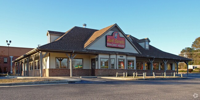
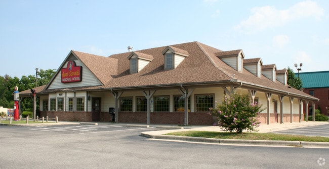
Property Record
4935 Raleigh Road Pkwy W, Wilson, NC 27896
NEARBY LISTINGS FOR SALE OR LEASE
Property Detail
4935 Raleigh Road Pkwy W
2793-63-7845.000
4935 RALEIGH ROAD PKWY W L1 1.00LT
Medicalbuilding
Wilson
X
North Carolina
3720279300K
95
2024
1.01 AC
2025
Rocky Mount/Wilson
001502
Other Market Areas
5,066 SF
Wilson, NC
DEMOGRAPHICS near 4935 Raleigh Road Pkwy W
1 Mile
3 Mile
5 Mile
2024 Total Population
200
10,821
38,072
2029 Population
203
10,937
38,071
Pop Growth 2024-2029
+ 1.50%
+ 1.07%
0.00%
Average Age
39
39
42
2024 Total Households
84
4,478
15,996
HH Growth 2024-2029
+ 1.19%
+ 1.07%
(0.04%)
Median Household Inc
$53,095
$53,974
$56,054
Avg Household Size
2.40
2.40
2.30
2024 Avg HH Vehicles
2.00
2.00
2.00
Median Home Value
$151,388
$156,242
$166,799
Median Year Built
1998
1996
1989
Nearby Places
- Restaurants
- Banks
- Shops
- Fitness
- Groceries
PUBLIC TRANSPORTATION
COMMUTER RAIL
Wilson (Carolinian - Amtrak, Palmetto - Amtrak)
DRIVE
WALK
Distance
Wilson (Carolinian - Amtrak, Palmetto - Amtrak)
11 min
6.6 mi
Freight Ports
Port of Morehead City
DRIVE
WALK
Distance
Port of Morehead City
172 min
131.2 mi
Nearby Properties
Address
Land Use
TOTAL SIZE
Lot Size
Zoning
Address
Land Use
TOTAL SIZE
Lot Size
Zoning
125,586 SF
61.33 AC
HI
Address
Land Use
TOTAL SIZE
Lot Size
Zoning
25,554 SF
18.75 AC
RMX
Address
Land Use
TOTAL SIZE
Lot Size
Zoning
624 SF
216.49 AC
M2
Address
Land Use
TOTAL SIZE
Lot Size
Zoning
232,805 SF
49.53 AC
HI
Address
Land Use
TOTAL SIZE
Lot Size
Zoning
14,520 SF
642.25 AC
HI
Address
Land Use
TOTAL SIZE
Lot Size
Zoning
159,765 SF
74.19 AC
AR
Address
Land Use
TOTAL SIZE
Lot Size
Zoning
11,375 SF
29.21 AC
HI
Address
Land Use
TOTAL SIZE
Lot Size
Zoning
4,803 SF
10.23 AC
RMX
Address
Land Use
TOTAL SIZE
Lot Size
Zoning
98,777 SF
50 AC
ICD
Address
Land Use
TOTAL SIZE
Lot Size
Zoning
338,739 SF
29.79 AC
HI
Address
Land Use
TOTAL SIZE
Lot Size
Zoning
11,664 SF
10.13 AC
HC
Address
Land Use
TOTAL SIZE
Lot Size
Zoning
11,760 SF
56.76 AC
ICD
Address
Land Use
TOTAL SIZE
Lot Size
Zoning
135,620 SF
31.85 AC
HI
Address
Land Use
TOTAL SIZE
Lot Size
Zoning
111,191 SF
10.64 AC
B4
Address
Land Use
TOTAL SIZE
Lot Size
Zoning
27,488 SF
17.21 AC
GR6
Address
Land Use
TOTAL SIZE
Lot Size
Zoning
1,942 SF
28.23 AC
HI
Address
Land Use
TOTAL SIZE
Lot Size
Zoning
30,676 SF
9.09 AC
GC
Address
Land Use
TOTAL SIZE
Lot Size
Zoning
43,522 SF
28.26 AC
ICD
Address
Land Use
TOTAL SIZE
Lot Size
Zoning
17,859 SF
8 AC
SR4
Address
Land Use
TOTAL SIZE
Lot Size
Zoning
8,800 SF
7.51 AC
GC
Address
Land Use
TOTAL SIZE
Lot Size
Zoning
6,312 SF
10.97 AC
GC
Address
Land Use
TOTAL SIZE
Lot Size
Zoning
35,448 SF
5.71 AC
GC
Address
Land Use
TOTAL SIZE
Lot Size
Zoning
71,781 SF
26.09 AC
HC
Address
Land Use
TOTAL SIZE
Lot Size
Zoning
138,421 SF
49.29 AC
HI
Address
Land Use
TOTAL SIZE
Lot Size
Zoning
49,356 SF
2.48 AC
GC
Address
Land Use
TOTAL SIZE
Lot Size
Zoning
35,905 SF
13.32 AC
NC
Address
Land Use
TOTAL SIZE
Lot Size
Zoning
34,093 SF
2.04 AC
GC
Address
Land Use
TOTAL SIZE
Lot Size
Zoning
104,976 SF
11.72 AC
Address
Land Use
TOTAL SIZE
Lot Size
Zoning
39,291 SF
1.94 AC
GC
Address
Land Use
TOTAL SIZE
Lot Size
Zoning
41,548 SF
2.33 AC
GC
The World's #1 Commercial Real Estate Marketplace
Connect with us
© 2025 CoStar Group
The information above has been obtained from sources believed reliable. While we do not doubt its accuracy we have not verified it and make no guarantee, warranty or representation about it. It is your responsibility to independently confirm its accuracy and completeness. Any projections, opinions, assumptions, or estimates used are for example only and do not represent the current or future performance of the property. The value of this transaction to you depends on tax and other factors which should be evaluated by your tax, financial, and legal advisors. You and your advisors should conduct a careful, independent investigation of the property to determine to your satisfaction the suitability of the property for your needs.