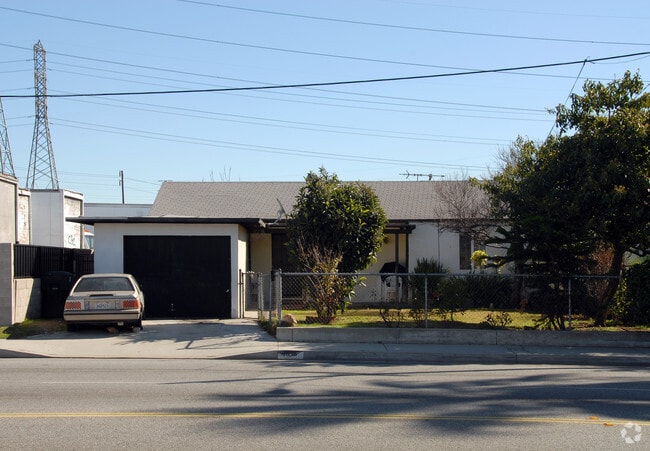
Property Record
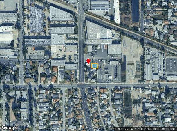
4918 Walnut Grove Ave, San Gabriel, CA 91776
NEARBY LISTINGS FOR SALE OR LEASE
Property Detail
4918 Walnut Grove Ave
Los Angeles-Long Beach-Glendale, CA
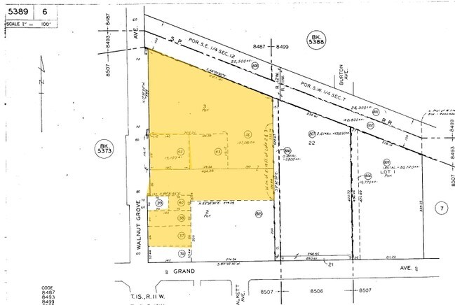
Baldy View Tract
5389-006-040
BALDY VIEW TRACT E 70 FT OF W 140 FT OF N 50 FT OF S 219.44 FT OF LOT 2
Industrialgeneral
Los Angeles
X
California
06037C1675F
2
2024
0.08 AC
2025
Lower San Gabriel Valley
432201
Los Angeles
560 SF
DEMOGRAPHICS near 4918 Walnut Grove Ave
1 Mile
3 Mile
5 Mile
2024 Total Population
28,218
249,751
590,267
2029 Population
27,215
241,321
570,688
Pop Growth 2024-2029
(3.55%)
(3.38%)
(3.32%)
Average Age
42
42
42
2024 Total Households
8,718
79,342
196,020
HH Growth 2024-2029
(3.84%)
(3.60%)
(3.51%)
Median Household Inc
$76,006
$74,929
$81,199
Avg Household Size
3.10
3.00
2.90
2024 Avg HH Vehicles
2.00
2.00
2.00
Median Home Value
$792,379
$825,938
$830,310
Median Year Built
1959
1960
1960
Nearby Places
Map Layers
Map Styles
 Street
 Aerial
- Restaurants
- Banks
- Shops
- Fitness
- Groceries
PUBLIC TRANSPORTATION
COMMUTER RAIL
El Monte (San Bernardino Line - Southern California Regional Rail Authority (Metrolink))
DRIVE
WALK
Distance
El Monte (San Bernardino Line - Southern California Regional Rail Authority (Metrolink))
7 min
3.3 mi
AIRPORT
Bob Hope
DRIVE
WALK
Distance
Bob Hope
34 min
25.5 mi
Long Beach (Daugherty Field)
DRIVE
WALK
Distance
Long Beach (Daugherty Field)
36 min
25.9 mi
Los Angeles International
DRIVE
WALK
Distance
Los Angeles International
40 min
26.9 mi
Freight Ports
Port of Long Beach
DRIVE
WALK
Distance
Port of Long Beach
38 min
28.8 mi
Nearby Properties
Address
Land Use
TOTAL SIZE
Lot Size
Zoning
Address
Land Use
TOTAL SIZE
Lot Size
Zoning
91,229 SF
206.59 AC
SOH
Address
Land Use
TOTAL SIZE
Lot Size
Zoning
516,474 SF
4.37 AC
ALCBD/DRD*
Address
Land Use
TOTAL SIZE
Lot Size
Zoning
665,195 SF
29.38 AC
EMM2*
Address
Land Use
TOTAL SIZE
Lot Size
Zoning
247,960 SF
1.99 AC
SLC3
Address
Land Use
TOTAL SIZE
Lot Size
Zoning
572,320 SF
25.65 AC
EMM2*
Address
Land Use
TOTAL SIZE
Lot Size
Zoning
593,133 SF
SLR1YY
Address
Land Use
TOTAL SIZE
Lot Size
Zoning
334,580 SF
8.01 AC
EMM2
Address
Land Use
TOTAL SIZE
Lot Size
Zoning
220,142 SF
9.92 AC
SLR1VV
Address
Land Use
TOTAL SIZE
Lot Size
Zoning
193,192 SF
9.37 AC
EMM2*
Address
Land Use
TOTAL SIZE
Lot Size
Zoning
198,728 SF
2.50 AC
SLR3YY
Address
Land Use
TOTAL SIZE
Lot Size
Zoning
16.15 AC
EMM2*
Address
Land Use
TOTAL SIZE
Lot Size
Zoning
116,898 SF
4.36 AC
EMR3*
Address
Land Use
TOTAL SIZE
Lot Size
Zoning
227,731 SF
20.80 AC
RMC3-R3*
Address
Land Use
TOTAL SIZE
Lot Size
Zoning
331,660 SF
7.34 AC
RMC3*
Address
Land Use
TOTAL SIZE
Lot Size
Zoning
320,844 SF
6.45 AC
SLCHR*
Address
Land Use
TOTAL SIZE
Lot Size
Zoning
168,334 SF
7.41 AC
EMM2*
Address
Land Use
TOTAL SIZE
Lot Size
Zoning
121,746 SF
4.91 AC
EMR4*
Address
Land Use
TOTAL SIZE
Lot Size
Zoning
255,384 SF
6.74 AC
ARC2*
Address
Land Use
TOTAL SIZE
Lot Size
Zoning
95,187 SF
3.10 AC
EMC4*
Address
Land Use
TOTAL SIZE
Lot Size
Zoning
85,890 SF
2.33 AC
MPR2SCH*
Address
Land Use
TOTAL SIZE
Lot Size
Zoning
107,394 SF
4.40 AC
EMR4*
Address
Land Use
TOTAL SIZE
Lot Size
Zoning
189,263 SF
2.81 AC
EMM2*
Address
Land Use
TOTAL SIZE
Lot Size
Zoning
69,352 SF
4.78 AC
ARC2
Address
Land Use
TOTAL SIZE
Lot Size
Zoning
213,932 SF
7.03 AC
EMM2*
Address
Land Use
TOTAL SIZE
Lot Size
Zoning
48,018 SF
2.64 AC
SLC3*
Address
Land Use
TOTAL SIZE
Lot Size
Zoning
54,368 SF
1.20 AC
SLR3YY
Address
Land Use
TOTAL SIZE
Lot Size
Zoning
82,188 SF
1.20 AC
ALCBD/DRD*
Address
Land Use
TOTAL SIZE
Lot Size
Zoning
41,761 SF
3.25 AC
ALCPD-R1*
Address
Land Use
TOTAL SIZE
Lot Size
Zoning
139,100 SF
6.45 AC
EMM2*
The World's #1 Commercial Real Estate Marketplace
Connect with us
© 2025 CoStar Group
The information above has been obtained from sources believed reliable. While we do not doubt its accuracy we have not verified it and make no guarantee, warranty or representation about it. It is your responsibility to independently confirm its accuracy and completeness. Any projections, opinions, assumptions, or estimates used are for example only and do not represent the current or future performance of the property. The value of this transaction to you depends on tax and other factors which should be evaluated by your tax, financial, and legal advisors. You and your advisors should conduct a careful, independent investigation of the property to determine to your satisfaction the suitability of the property for your needs.