Property Record
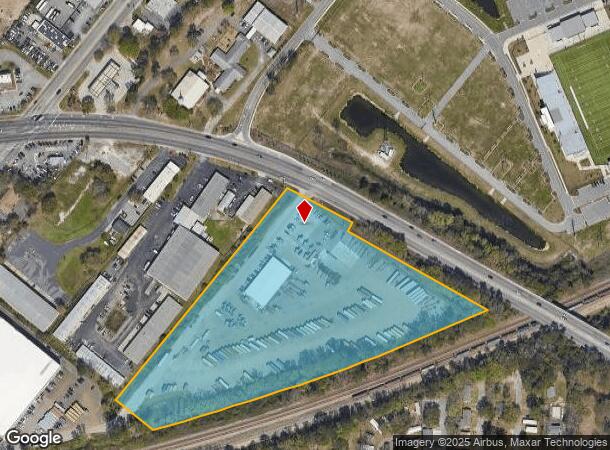
4935 Dorchester Rd, North Charleston, SC 29418

Current Lease Availabilities
NEARBY LISTINGS FOR SALE OR LEASE
Property Detail
4935 Dorchester Rd
408-16-00-041
Part Wando
Commercialnec
DESCRIPTION -TRACT B PART WANDO TRACT SITE NAME -SW SIDE APPROX 900FT SE MONTGUE AVE
X
Charleston
45019C0482K
South Carolina
2025
10.93 AC
2024
North Charleston
003110
Charleston/N Charleston
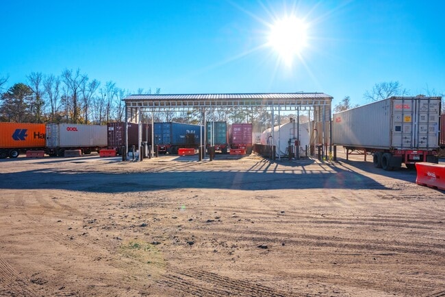
5,712 SF
Charleston-North Charleston, SC
DEMOGRAPHICS near 4935 Dorchester Rd
1 Mile
3 Mile
5 Mile
2024 Total Population
5,426
51,086
138,223
2029 Population
5,735
54,715
148,851
Pop Growth 2024-2029
+ 5.69%
+ 7.10%
+ 7.69%
Average Age
41
40
39
2024 Total Households
2,076
21,292
58,769
HH Growth 2024-2029
+ 5.54%
+ 6.99%
+ 7.51%
Median Household Inc
$50,974
$53,319
$57,272
Avg Household Size
2.30
2.30
2.20
2024 Avg HH Vehicles
2.00
2.00
2.00
Median Home Value
$167,823
$242,809
$261,910
Median Year Built
1976
1980
1982
Nearby Places
- Restaurants
- Banks
- Shops
- Fitness
- Groceries
PUBLIC TRANSPORTATION
COMMUTER RAIL
Charleston Amtrak Station (Palmetto - Amtrak, Silver Meteor - Amtrak)
DRIVE
WALK
Distance
Charleston Amtrak Station (Palmetto - Amtrak, Silver Meteor - Amtrak)
6 min
3.2 mi
AIRPORT
Charleston AFB/International
DRIVE
WALK
Distance
Charleston AFB/International
8 min
5.3 mi
Freight Ports
North Charleston Terminal
DRIVE
WALK
Distance
North Charleston Terminal
8 min
5.6 mi
Nearby Properties
Address
Land Use
TOTAL SIZE
Lot Size
Zoning
Address
Land Use
TOTAL SIZE
Lot Size
Zoning
1,717 SF
40.95 AC
Address
Land Use
TOTAL SIZE
Lot Size
Zoning
9,778 SF
11.90 AC
Address
Land Use
TOTAL SIZE
Lot Size
Zoning
68,655 SF
9.48 AC
Address
Land Use
TOTAL SIZE
Lot Size
Zoning
36,587 SF
17.75 AC
Address
Land Use
TOTAL SIZE
Lot Size
Zoning
10,560 SF
7.50 AC
Address
Land Use
TOTAL SIZE
Lot Size
Zoning
4,740 SF
12.17 AC
Address
Land Use
TOTAL SIZE
Lot Size
Zoning
17,271 SF
3.65 AC
Address
Land Use
TOTAL SIZE
Lot Size
Zoning
112,860 SF
12 AC
Address
Land Use
TOTAL SIZE
Lot Size
Zoning
6,036 SF
8.79 AC
Address
Land Use
TOTAL SIZE
Lot Size
Zoning
19,992 SF
11.98 AC
Address
Land Use
TOTAL SIZE
Lot Size
Zoning
5.54 AC
Address
Land Use
TOTAL SIZE
Lot Size
Zoning
42,500 SF
3.62 AC
Address
Land Use
TOTAL SIZE
Lot Size
Zoning
1,303 SF
4.77 AC
Address
Land Use
TOTAL SIZE
Lot Size
Zoning
3,192 SF
34.47 AC
Address
Land Use
TOTAL SIZE
Lot Size
Zoning
30,064 SF
33.86 AC
Address
Land Use
TOTAL SIZE
Lot Size
Zoning
3,275 SF
4.18 AC
Address
Land Use
TOTAL SIZE
Lot Size
Zoning
16,917 SF
2.40 AC
Address
Land Use
TOTAL SIZE
Lot Size
Zoning
50,356 SF
5.19 AC
Address
Land Use
TOTAL SIZE
Lot Size
Zoning
6,531 SF
3.11 AC
Address
Land Use
TOTAL SIZE
Lot Size
Zoning
17,127 SF
2.52 AC
Address
Land Use
TOTAL SIZE
Lot Size
Zoning
25.97 AC
Address
Land Use
TOTAL SIZE
Lot Size
Zoning
86,024 SF
9.69 AC
Address
Land Use
TOTAL SIZE
Lot Size
Zoning
2,438 SF
33.72 AC
Address
Land Use
TOTAL SIZE
Lot Size
Zoning
896 SF
6.09 AC
Address
Land Use
TOTAL SIZE
Lot Size
Zoning
14,250 SF
2.08 AC
Address
Land Use
TOTAL SIZE
Lot Size
Zoning
Address
Land Use
TOTAL SIZE
Lot Size
Zoning
Address
Land Use
TOTAL SIZE
Lot Size
Zoning
Address
Land Use
TOTAL SIZE
Lot Size
Zoning
28,580 SF
7.65 AC
Address
Land Use
TOTAL SIZE
Lot Size
Zoning
223,815 SF
5.73 AC
The World's #1 Commercial Real Estate Marketplace
Connect with us
© 2025 CoStar Group
The information above has been obtained from sources believed reliable. While we do not doubt its accuracy we have not verified it and make no guarantee, warranty or representation about it. It is your responsibility to independently confirm its accuracy and completeness. Any projections, opinions, assumptions, or estimates used are for example only and do not represent the current or future performance of the property. The value of this transaction to you depends on tax and other factors which should be evaluated by your tax, financial, and legal advisors. You and your advisors should conduct a careful, independent investigation of the property to determine to your satisfaction the suitability of the property for your needs.