Property Record
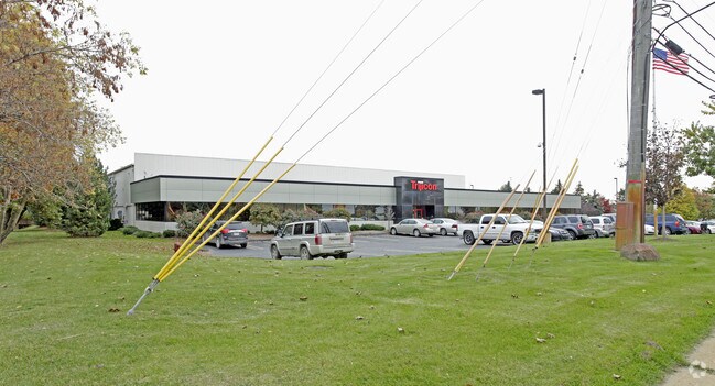
49385 Shafer Ct, Wixom, MI 48393


Property Detail
49385 Shafer Ct
22-05-151-010
T1N, R8E, SEC 5 PART OF NW 1/4 BEG AT PT DIST N 00-01-51 E 1005 FT & N 89-20-20 E 60 FT FROM W 1/4 COR, TH N 00-01-51 E 315 FT, TH S 89-20-20 E 675 FT, TH S 00-01-51 W 315 FT, TH N 89-20-20 W 243.87 FT, TH N 00-01-51 W 30 FT, TH N 89-20-20 W 58.66 FT
Scientificpharmaceuticalmedicalresearchfacility
Oakland
M1
Michigan
B and X Area of moderate flood hazard, usually the area between the limits of the 100-year and 500-year floods.
4.81 AC
2025
Central I-96 Corridor
2025
Detroit
133102
Detroit-Warren-Dearborn, MI
43,139 SF
NEARBY LISTINGS FOR SALE OR LEASE
DEMOGRAPHICS near 49385 Shafer Ct
1 mile
3 mile
5 mile
2025 Total Population
6,224
41,245
108,023
2030 Population
6,000
41,653
110,541
Pop Growth 2025-2030
(3.60%)
+ 0.99%
+ 2.33%
Average Age
37
39
41
2025 Total Households
3,682
18,003
44,337
HH Growth 2025-2030
(4.10%)
+ 0.56%
+ 2.06%
Median Household Inc
$53,995
$81,334
$98,838
Avg Household Size
1.70
2.30
2.40
2025 Avg HH Vehicles
1.00
2.00
2.00
Median Home Value
$330,748
$356,628
$391,498
Median Year Built
1981
1991
1993
Nearby Places
Map Layers
Map Styles
 Street
 Aerial
Layers
 Traffic
 Biking
Places
Listings with unknown addresses are not visible on the map
- Restaurants
- Banks
- Shops
- Fitness
- Groceries
PUBLIC TRANSPORTATION
AIRPORT
Detroit Metro Wayne County
Drive
Walk
Distance
Detroit Metro Wayne County
37 min
31.4 mi
Freight Ports
Port of Toledo
Drive
Walk
Distance
Port of Toledo
87 min
73.1 mi
Nearby Properties
Address
Land Use
TOTAL SIZE
Lot Size
Zoning
Address
Land Use
TOTAL SIZE
Lot Size
Zoning
873,288 SF
Address
Land Use
TOTAL SIZE
Lot Size
Zoning
741,000 SF
Address
Land Use
TOTAL SIZE
Lot Size
Zoning
72.63 AC
RM-1
Address
Land Use
TOTAL SIZE
Lot Size
Zoning
86.19 AC
RC2
Address
Land Use
TOTAL SIZE
Lot Size
Zoning
563,160 SF
47.06 AC
Address
Land Use
TOTAL SIZE
Lot Size
Zoning
12,872 SF
43.06 AC
RM-1
Address
Land Use
TOTAL SIZE
Lot Size
Zoning
20.71 AC
OSC
Address
Land Use
TOTAL SIZE
Lot Size
Zoning
59.71 AC
RM-1
Address
Land Use
TOTAL SIZE
Lot Size
Zoning
306,280 SF
Address
Land Use
TOTAL SIZE
Lot Size
Zoning
144.50 AC
OSC
Address
Land Use
TOTAL SIZE
Lot Size
Zoning
63.31 AC
OST-EXO
Address
Land Use
TOTAL SIZE
Lot Size
Zoning
325,725 SF
30.46 AC
Address
Land Use
TOTAL SIZE
Lot Size
Zoning
184,225 SF
13.84 AC
OSC
Address
Land Use
TOTAL SIZE
Lot Size
Zoning
38.85 AC
RC2
Address
Land Use
TOTAL SIZE
Lot Size
Zoning
256,880 SF
Address
Land Use
TOTAL SIZE
Lot Size
Zoning
OST-EXO
Address
Land Use
TOTAL SIZE
Lot Size
Zoning
Address
Land Use
TOTAL SIZE
Lot Size
Zoning
140,366 SF
30.67 AC
II
Address
Land Use
TOTAL SIZE
Lot Size
Zoning
132,288 SF
Address
Land Use
TOTAL SIZE
Lot Size
Zoning
4,140 SF
120 AC
MM
Address
Land Use
TOTAL SIZE
Lot Size
Zoning
126,720 SF
8.31 AC
Address
Land Use
TOTAL SIZE
Lot Size
Zoning
172,700 SF
Address
Land Use
TOTAL SIZE
Lot Size
Zoning
7,471 SF
114.63 AC
MM
Address
Land Use
TOTAL SIZE
Lot Size
Zoning
25.58 AC
RC1
Address
Land Use
TOTAL SIZE
Lot Size
Zoning
243,502 SF
Address
Land Use
TOTAL SIZE
Lot Size
Zoning
279,807 SF
31.24 AC
II
Address
Land Use
TOTAL SIZE
Lot Size
Zoning
200,926 SF
30.87 AC
M1
Address
Land Use
TOTAL SIZE
Lot Size
Zoning
26.54 AC
RM-1
Address
Land Use
TOTAL SIZE
Lot Size
Zoning
14.93 AC
RC2
Address
Land Use
TOTAL SIZE
Lot Size
Zoning
101,752 SF
7.20 AC
The World's #1 Commercial Real Estate Marketplace
Connect with us
© 2026 CoStar Group
The information above has been obtained from sources believed reliable. While we do not doubt its accuracy we have not verified it and make no guarantee, warranty or representation about it. It is your responsibility to independently confirm its accuracy and completeness. Any projections, opinions, assumptions, or estimates used are for example only and do not represent the current or future performance of the property. The value of this transaction to you depends on tax and other factors which should be evaluated by your tax, financial, and legal advisors. You and your advisors should conduct a careful, independent investigation of the property to determine to your satisfaction the suitability of the property for your needs.