Property Record
4939 Rendon Rd, Fort Worth, TX 76140

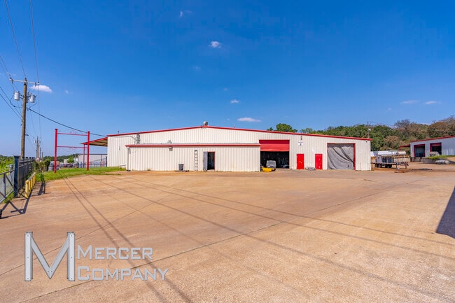
This Property Is For Sale
Property Detail
4939 Rendon Rd
05001463
DAVIDSON, WASH SURVEY ABSTRACT 394 TRACT 7A & 9A3
Industrialgeneral
TARRANT
B and X Area of moderate flood hazard, usually the area between the limits of the 100-year and 500-year floods.
Texas
2024
3.89 AC
2025
S Cen.Tarrant Cnty
111317
Dallas/Ft Worth
49,174 SF
Dallas-Fort Worth-Arlington, TX
NEARBY LISTINGS FOR SALE OR LEASE
DEMOGRAPHICS near 4939 Rendon Rd
1 mile
3 mile
5 mile
2025 Total Population
1,630
23,702
86,073
2030 Population
1,726
25,318
91,869
Pop Growth 2025-2030
+ 5.89%
+ 6.82%
+ 6.73%
Average Age
42
39
37
2025 Total Households
587
7,927
28,269
HH Growth 2025-2030
+ 6.13%
+ 6.94%
+ 6.91%
Median Household Inc
$96,175
$91,835
$88,629
Avg Household Size
2.70
2.90
3.00
2025 Avg HH Vehicles
3.00
2.00
2.00
Median Home Value
$336,974
$334,107
$323,260
Median Year Built
1986
1998
1998
Nearby Places
Map Layers
Map Styles
 Street
 Aerial
Layers
 Traffic
 Biking
Places
Listings with unknown addresses are not visible on the map
- Restaurants
- Banks
- Shops
- Fitness
- Groceries
PUBLIC TRANSPORTATION
AIRPORT
Dallas-Fort Worth International
Drive
Walk
Distance
Dallas-Fort Worth International
46 min
33.4 mi
Dallas Love Field
Drive
Walk
Distance
Dallas Love Field
57 min
43.2 mi
Freight Ports
Port of Shreveport
Drive
Walk
Distance
Port of Shreveport
248 min
228.9 mi
Nearby Properties
Address
Land Use
TOTAL SIZE
Lot Size
Zoning
Address
Land Use
TOTAL SIZE
Lot Size
Zoning
987,261 SF
63.16 AC
Address
Land Use
TOTAL SIZE
Lot Size
Zoning
199,066 SF
66.49 AC
Address
Land Use
TOTAL SIZE
Lot Size
Zoning
266,888 SF
20.85 AC
Address
Land Use
TOTAL SIZE
Lot Size
Zoning
279,543 SF
11.54 AC
Address
Land Use
TOTAL SIZE
Lot Size
Zoning
234,855 SF
33.10 AC
Address
Land Use
TOTAL SIZE
Lot Size
Zoning
141,411 SF
32.16 AC
Address
Land Use
TOTAL SIZE
Lot Size
Zoning
Address
Land Use
TOTAL SIZE
Lot Size
Zoning
101,412 SF
7.36 AC
Address
Land Use
TOTAL SIZE
Lot Size
Zoning
96,000 SF
28.83 AC
Address
Land Use
TOTAL SIZE
Lot Size
Zoning
98,914 SF
5.96 AC
Address
Land Use
TOTAL SIZE
Lot Size
Zoning
3,852 SF
5.75 AC
Address
Land Use
TOTAL SIZE
Lot Size
Zoning
37,500 SF
1 AC
Address
Land Use
TOTAL SIZE
Lot Size
Zoning
45,285 SF
19.97 AC
Address
Land Use
TOTAL SIZE
Lot Size
Zoning
45,862 SF
6 AC
Address
Land Use
TOTAL SIZE
Lot Size
Zoning
41,104 SF
2.87 AC
Address
Land Use
TOTAL SIZE
Lot Size
Zoning
66,000 SF
10.35 AC
Address
Land Use
TOTAL SIZE
Lot Size
Zoning
58,437 SF
17 AC
Address
Land Use
TOTAL SIZE
Lot Size
Zoning
36,348 SF
7.52 AC
Address
Land Use
TOTAL SIZE
Lot Size
Zoning
49,880 SF
13.27 AC
Address
Land Use
TOTAL SIZE
Lot Size
Zoning
35,790 SF
2.30 AC
Address
Land Use
TOTAL SIZE
Lot Size
Zoning
30,302 SF
2.50 AC
Address
Land Use
TOTAL SIZE
Lot Size
Zoning
47,334 SF
5 AC
Address
Land Use
TOTAL SIZE
Lot Size
Zoning
35,110 SF
4.58 AC
Address
Land Use
TOTAL SIZE
Lot Size
Zoning
50,000 SF
4.70 AC
Address
Land Use
TOTAL SIZE
Lot Size
Zoning
41,980 SF
7.56 AC
Address
Land Use
TOTAL SIZE
Lot Size
Zoning
13,238 SF
4.68 AC
Address
Land Use
TOTAL SIZE
Lot Size
Zoning
48,000 SF
12.16 AC
Address
Land Use
TOTAL SIZE
Lot Size
Zoning
1,719 SF
84.72 AC
Address
Land Use
TOTAL SIZE
Lot Size
Zoning
31,300 SF
2.50 AC
The World's #1 Commercial Real Estate Marketplace
Connect with us
© 2026 CoStar Group
The information above has been obtained from sources believed reliable. While we do not doubt its accuracy we have not verified it and make no guarantee, warranty or representation about it. It is your responsibility to independently confirm its accuracy and completeness. Any projections, opinions, assumptions, or estimates used are for example only and do not represent the current or future performance of the property. The value of this transaction to you depends on tax and other factors which should be evaluated by your tax, financial, and legal advisors. You and your advisors should conduct a careful, independent investigation of the property to determine to your satisfaction the suitability of the property for your needs.