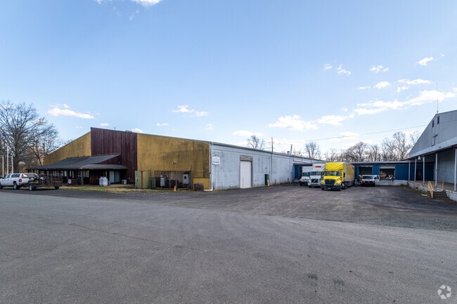
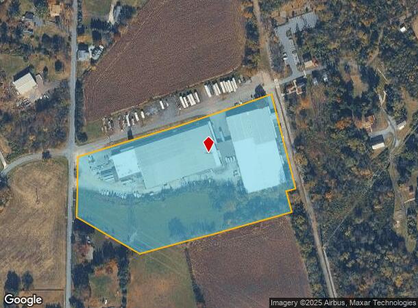
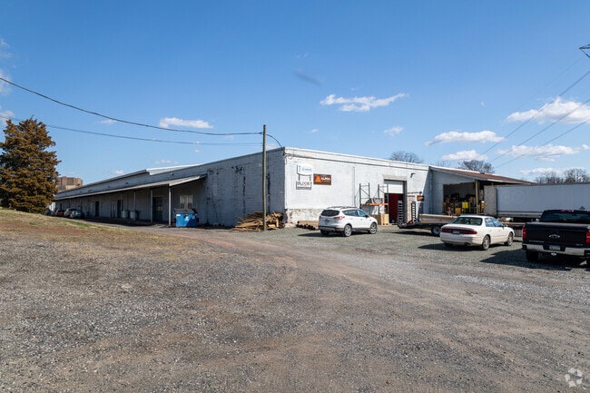
Property Record
498 Fricks Lock Rd, Pottstown, PA 19465
Current Lease Availabilities
NEARBY LISTINGS FOR SALE OR LEASE
Property Detail
498 Fricks Lock Rd
18-001-0034.0200
Janaline Realty Inc
Warehouse
10.7 AC & COMM BLDG
X
Chester
42029C0020G
Pennsylvania
2024
10.70 AC
2025
Chester
301300
Philadelphia
134,970 SF
Philadelphia-Camden-Wilmington, PA-NJ-DE-MD
DEMOGRAPHICS near 498 Fricks Lock Rd
1 Mile
3 Mile
5 Mile
2024 Total Population
650
35,500
104,244
2029 Population
670
36,424
106,785
Pop Growth 2024-2029
+ 3.08%
+ 2.60%
+ 2.44%
Average Age
40
41
40
2024 Total Households
254
13,580
40,484
HH Growth 2024-2029
+ 3.15%
+ 2.68%
+ 2.48%
Median Household Inc
$112,500
$82,576
$84,070
Avg Household Size
2.50
2.50
2.50
2024 Avg HH Vehicles
2.00
2.00
2.00
Median Home Value
$275,772
$255,810
$270,717
Median Year Built
2000
1973
1974
Nearby Places
Map Layers
Map Styles
 Street
 Aerial
- Restaurants
- Banks
- Shops
- Fitness
- Groceries
Nearby Properties
Address
Land Use
TOTAL SIZE
Lot Size
Zoning
Address
Land Use
TOTAL SIZE
Lot Size
Zoning
605,161 SF
78.08 AC
LLI
Address
Land Use
TOTAL SIZE
Lot Size
Zoning
707,965 SF
80.33 AC
RMHD
Address
Land Use
TOTAL SIZE
Lot Size
Zoning
368,083 SF
126.15 AC
R2
Address
Land Use
TOTAL SIZE
Lot Size
Zoning
327,827 SF
21 AC
RMD
Address
Land Use
TOTAL SIZE
Lot Size
Zoning
1,298,806 SF
305.46 AC
HI
Address
Land Use
TOTAL SIZE
Lot Size
Zoning
309,443 SF
20.56 AC
GE
Address
Land Use
TOTAL SIZE
Lot Size
Zoning
181,947 SF
8.19 AC
RMD
Address
Land Use
TOTAL SIZE
Lot Size
Zoning
240,140 SF
31.50 AC
R3
Address
Land Use
TOTAL SIZE
Lot Size
Zoning
123,946 SF
39.60 AC
R2
Address
Land Use
TOTAL SIZE
Lot Size
Zoning
147,444 SF
16.09 AC
LLI
Address
Land Use
TOTAL SIZE
Lot Size
Zoning
84,953 SF
51.29 AC
R2
Address
Land Use
TOTAL SIZE
Lot Size
Zoning
94,997 SF
6 AC
R3
Address
Land Use
TOTAL SIZE
Lot Size
Zoning
214,914 SF
48.17 AC
OLI
Address
Land Use
TOTAL SIZE
Lot Size
Zoning
222,272 SF
21.60 AC
OLI
Address
Land Use
TOTAL SIZE
Lot Size
Zoning
681,836 SF
40.12 AC
HI
Address
Land Use
TOTAL SIZE
Lot Size
Zoning
245,651 SF
20.79 AC
R2
Address
Land Use
TOTAL SIZE
Lot Size
Zoning
166,912 SF
11.10 AC
R4
Address
Land Use
TOTAL SIZE
Lot Size
Zoning
68,775 SF
14.91 AC
OLI
Address
Land Use
TOTAL SIZE
Lot Size
Zoning
66,270 SF
1.20 AC
R1
Address
Land Use
TOTAL SIZE
Lot Size
Zoning
73,584 SF
0.74 AC
LI
Address
Land Use
TOTAL SIZE
Lot Size
Zoning
73,584 SF
0.64 AC
LI
Address
Land Use
TOTAL SIZE
Lot Size
Zoning
73,584 SF
0.72 AC
LI
Address
Land Use
TOTAL SIZE
Lot Size
Zoning
73,584 SF
0.68 AC
LI
Address
Land Use
TOTAL SIZE
Lot Size
Zoning
0.70 AC
LI
Address
Land Use
TOTAL SIZE
Lot Size
Zoning
86,532 SF
13 AC
R3
Address
Land Use
TOTAL SIZE
Lot Size
Zoning
77,944 SF
0.47 AC
D
Address
Land Use
TOTAL SIZE
Lot Size
Zoning
39,310 SF
4.63 AC
OLI
Address
Land Use
TOTAL SIZE
Lot Size
Zoning
73,443 SF
13.14 AC
R2
Address
Land Use
TOTAL SIZE
Lot Size
Zoning
74,550 SF
19.60 AC
R2
Address
Land Use
TOTAL SIZE
Lot Size
Zoning
66,912 SF
4 AC
R3
The World's #1 Commercial Real Estate Marketplace
Connect with us
© 2026 CoStar Group
The information above has been obtained from sources believed reliable. While we do not doubt its accuracy we have not verified it and make no guarantee, warranty or representation about it. It is your responsibility to independently confirm its accuracy and completeness. Any projections, opinions, assumptions, or estimates used are for example only and do not represent the current or future performance of the property. The value of this transaction to you depends on tax and other factors which should be evaluated by your tax, financial, and legal advisors. You and your advisors should conduct a careful, independent investigation of the property to determine to your satisfaction the suitability of the property for your needs.