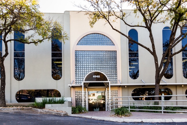
Property Record
4940 Broadway St, San Antonio, TX 78209


Current Lease Availabilities
NEARBY LISTINGS FOR SALE OR LEASE
Property Detail
4940 Broadway St
San Antonio-New Braunfels, TX
Conv A/S Code
04050-012-0030
CB 4050 BLK 12 LOT S 85 FT OF 1 & 2; LOT 3 EXC NW 65 X 25 FT;LOT 4-5; W 25 FT OF 6; N 70 FT OF 20- 22; & P-100 2018 MERGE 174240, 174241 INTO 174239 PER CR 43014 SCG/GIS 10/10/2017 2017- MERGE ACCTS 174239 & 174264 PER DEED 18077/1835
Officebuilding
Bexar
AE
Texas
48029C0402H
3
2024
1.02 AC
2025
Northeast
120301
San Antonio
26,322 SF
DEMOGRAPHICS near 4940 Broadway St
1 Mile
3 Mile
5 Mile
2024 Total Population
9,193
103,095
303,669
2029 Population
9,850
110,697
324,909
Pop Growth 2024-2029
+ 7.15%
+ 7.37%
+ 6.99%
Average Age
41
39
38
2024 Total Households
3,650
42,701
119,353
HH Growth 2024-2029
+ 7.62%
+ 7.68%
+ 7.36%
Median Household Inc
$153,760
$63,981
$47,965
Avg Household Size
2.20
2.20
2.40
2024 Avg HH Vehicles
2.00
2.00
2.00
Median Home Value
$719,315
$365,830
$198,103
Median Year Built
1962
1964
1964
Nearby Places
Map Layers
Map Styles
 Street
 Aerial
- Restaurants
- Banks
- Shops
- Fitness
- Groceries
PUBLIC TRANSPORTATION
COMMUTER RAIL
San Antonio Amtrak Station (Sunset Limited - Amtrak, Texas Eagle - Amtrak)
DRIVE
WALK
Distance
San Antonio Amtrak Station (Sunset Limited - Amtrak, Texas Eagle - Amtrak)
8 min
5.0 mi
AIRPORT
San Antonio International
DRIVE
WALK
Distance
San Antonio International
9 min
5.5 mi
Freight Ports
Calhoun Port
DRIVE
WALK
Distance
Calhoun Port
185 min
149.9 mi
Nearby Properties
Address
Land Use
TOTAL SIZE
Lot Size
Zoning
Address
Land Use
TOTAL SIZE
Lot Size
Zoning
2,544.56 AC
Address
Land Use
TOTAL SIZE
Lot Size
Zoning
339,590 SF
3.12 AC
Address
Land Use
TOTAL SIZE
Lot Size
Zoning
557,078 SF
10.73 AC
Address
Land Use
TOTAL SIZE
Lot Size
Zoning
5,106 SF
2.30 AC
Address
Land Use
TOTAL SIZE
Lot Size
Zoning
43,834 SF
3.11 AC
Address
Land Use
TOTAL SIZE
Lot Size
Zoning
178,534 SF
1.32 AC
Address
Land Use
TOTAL SIZE
Lot Size
Zoning
103,425 SF
4.76 AC
Address
Land Use
TOTAL SIZE
Lot Size
Zoning
11,915 SF
4.06 AC
Address
Land Use
TOTAL SIZE
Lot Size
Zoning
254,908 SF
1.92 AC
Address
Land Use
TOTAL SIZE
Lot Size
Zoning
173,422 SF
5.85 AC
Address
Land Use
TOTAL SIZE
Lot Size
Zoning
221,865 SF
3.12 AC
Address
Land Use
TOTAL SIZE
Lot Size
Zoning
246,000 SF
22.54 AC
Address
Land Use
TOTAL SIZE
Lot Size
Zoning
25,513 SF
18.14 AC
Address
Land Use
TOTAL SIZE
Lot Size
Zoning
303,199 SF
9.88 AC
Address
Land Use
TOTAL SIZE
Lot Size
Zoning
38.73 AC
Address
Land Use
TOTAL SIZE
Lot Size
Zoning
50.69 AC
Address
Land Use
TOTAL SIZE
Lot Size
Zoning
161,652 SF
1.79 AC
Address
Land Use
TOTAL SIZE
Lot Size
Zoning
11,915 SF
4.12 AC
Address
Land Use
TOTAL SIZE
Lot Size
Zoning
46,451 SF
7.03 AC
Address
Land Use
TOTAL SIZE
Lot Size
Zoning
Address
Land Use
TOTAL SIZE
Lot Size
Zoning
4,075 SF
2.80 AC
Address
Land Use
TOTAL SIZE
Lot Size
Zoning
9,390 SF
3.71 AC
Address
Land Use
TOTAL SIZE
Lot Size
Zoning
56,042 SF
14.60 AC
Address
Land Use
TOTAL SIZE
Lot Size
Zoning
219,419 SF
2.59 AC
Address
Land Use
TOTAL SIZE
Lot Size
Zoning
352,920 SF
2.48 AC
Address
Land Use
TOTAL SIZE
Lot Size
Zoning
262,515 SF
6.38 AC
Address
Land Use
TOTAL SIZE
Lot Size
Zoning
316,556 SF
6.56 AC
Address
Land Use
TOTAL SIZE
Lot Size
Zoning
10,342 SF
1.41 AC
Address
Land Use
TOTAL SIZE
Lot Size
Zoning
202,609 SF
3.25 AC
Address
Land Use
TOTAL SIZE
Lot Size
Zoning
71,253 SF
25.52 AC
The World's #1 Commercial Real Estate Marketplace
Connect with us
© 2025 CoStar Group
The information above has been obtained from sources believed reliable. While we do not doubt its accuracy we have not verified it and make no guarantee, warranty or representation about it. It is your responsibility to independently confirm its accuracy and completeness. Any projections, opinions, assumptions, or estimates used are for example only and do not represent the current or future performance of the property. The value of this transaction to you depends on tax and other factors which should be evaluated by your tax, financial, and legal advisors. You and your advisors should conduct a careful, independent investigation of the property to determine to your satisfaction the suitability of the property for your needs.