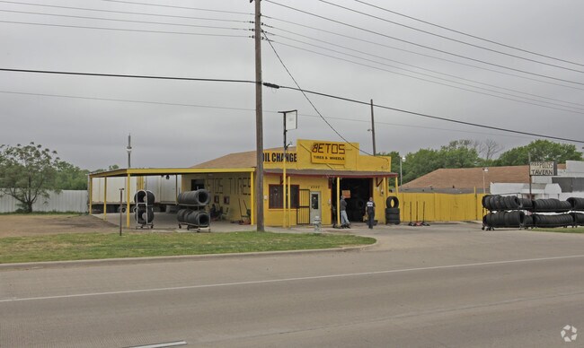
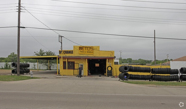
Property Record
4940 Mansfield Hwy, Forest Hill, TX 76119

NEARBY LISTINGS FOR SALE OR LEASE
Property Detail
4940 Mansfield Hwy
Dallas-Fort Worth-Arlington, TX
Jds Addition
42762586
JDS ADDITION BLOCK 1 LOT 1
Commercialnec
Tarrant
X
Texas
48439C0340K
1
2024
0.32 AC
2025
Southeast Fort Worth
111103
Dallas/Ft Worth
1,500 SF
DEMOGRAPHICS near 4940 Mansfield Hwy
1 Mile
3 Mile
5 Mile
2024 Total Population
9,936
76,480
207,067
2029 Population
10,467
80,701
218,855
Pop Growth 2024-2029
+ 5.34%
+ 5.52%
+ 5.69%
Average Age
36
36
37
2024 Total Households
3,443
24,883
67,815
HH Growth 2024-2029
+ 5.52%
+ 5.57%
+ 5.71%
Median Household Inc
$42,349
$51,050
$54,763
Avg Household Size
2.80
2.90
2.90
2024 Avg HH Vehicles
2.00
2.00
2.00
Median Home Value
$113,996
$185,009
$194,352
Median Year Built
1983
1980
1978
Nearby Places
Map Layers
Map Styles
 Street
 Aerial
- Restaurants
- Banks
- Shops
- Fitness
- Groceries
PUBLIC TRANSPORTATION
COMMUTER RAIL
Texas And Pacific (T&P) (Trinity Railway Express - Dallas Area Rapid Transit (DART))
DRIVE
WALK
Distance
Texas And Pacific (T&P) (Trinity Railway Express - Dallas Area Rapid Transit (DART))
13 min
8.3 mi
DRIVE
WALK
Distance
14 min
8.3 mi
AIRPORT
Dallas-Fort Worth International
DRIVE
WALK
Distance
Dallas-Fort Worth International
37 min
27.3 mi
Dallas Love Field
DRIVE
WALK
Distance
Dallas Love Field
47 min
36.0 mi
Nearby Properties
Address
Land Use
TOTAL SIZE
Lot Size
Zoning
Address
Land Use
TOTAL SIZE
Lot Size
Zoning
661,238 SF
38.80 AC
Address
Land Use
TOTAL SIZE
Lot Size
Zoning
593,917 SF
45.85 AC
Address
Land Use
TOTAL SIZE
Lot Size
Zoning
605,489 SF
35.12 AC
Address
Land Use
TOTAL SIZE
Lot Size
Zoning
488,564 SF
29.43 AC
Address
Land Use
TOTAL SIZE
Lot Size
Zoning
181,611 SF
24.44 AC
Address
Land Use
TOTAL SIZE
Lot Size
Zoning
224,000 SF
24.35 AC
Address
Land Use
TOTAL SIZE
Lot Size
Zoning
487,507 SF
145.80 AC
Address
Land Use
TOTAL SIZE
Lot Size
Zoning
186,894 SF
10.85 AC
Address
Land Use
TOTAL SIZE
Lot Size
Zoning
225,567 SF
13.01 AC
Address
Land Use
TOTAL SIZE
Lot Size
Zoning
353,875 SF
18.48 AC
Address
Land Use
TOTAL SIZE
Lot Size
Zoning
169,837 SF
9.44 AC
Address
Land Use
TOTAL SIZE
Lot Size
Zoning
180,556 SF
11.78 AC
Address
Land Use
TOTAL SIZE
Lot Size
Zoning
147,822 SF
9.45 AC
Address
Land Use
TOTAL SIZE
Lot Size
Zoning
124,224 SF
20.67 AC
Address
Land Use
TOTAL SIZE
Lot Size
Zoning
112,250 SF
12 AC
Address
Land Use
TOTAL SIZE
Lot Size
Zoning
301,302 SF
0.46 AC
Address
Land Use
TOTAL SIZE
Lot Size
Zoning
193,290 SF
10.56 AC
Address
Land Use
TOTAL SIZE
Lot Size
Zoning
239,360 SF
17.55 AC
Address
Land Use
TOTAL SIZE
Lot Size
Zoning
259,449 SF
24 AC
Address
Land Use
TOTAL SIZE
Lot Size
Zoning
159,030 SF
10.32 AC
Address
Land Use
TOTAL SIZE
Lot Size
Zoning
142,110 SF
7.40 AC
Address
Land Use
TOTAL SIZE
Lot Size
Zoning
115,345 SF
107.70 AC
Address
Land Use
TOTAL SIZE
Lot Size
Zoning
171,684 SF
8.12 AC
Address
Land Use
TOTAL SIZE
Lot Size
Zoning
4,886 SF
45.16 AC
Address
Land Use
TOTAL SIZE
Lot Size
Zoning
255,568 SF
14.79 AC
Address
Land Use
TOTAL SIZE
Lot Size
Zoning
498,850 SF
27.65 AC
Address
Land Use
TOTAL SIZE
Lot Size
Zoning
4,888 SF
31.18 AC
Address
Land Use
TOTAL SIZE
Lot Size
Zoning
2,058 SF
37.92 AC
Address
Land Use
TOTAL SIZE
Lot Size
Zoning
246,423 SF
18.84 AC
Address
Land Use
TOTAL SIZE
Lot Size
Zoning
189,323 SF
44.29 AC
The World's #1 Commercial Real Estate Marketplace
Connect with us
© 2025 CoStar Group
The information above has been obtained from sources believed reliable. While we do not doubt its accuracy we have not verified it and make no guarantee, warranty or representation about it. It is your responsibility to independently confirm its accuracy and completeness. Any projections, opinions, assumptions, or estimates used are for example only and do not represent the current or future performance of the property. The value of this transaction to you depends on tax and other factors which should be evaluated by your tax, financial, and legal advisors. You and your advisors should conduct a careful, independent investigation of the property to determine to your satisfaction the suitability of the property for your needs.