Property Record
4940 S Farm Road 189, Rogersville, MO 65742

NEARBY LISTINGS FOR SALE OR LEASE
-
-
View all Rogersville listings for sale on LoopNet.com
Property Detail
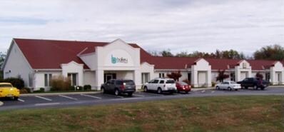
4940 S Farm Road 189
Springfield, MO
Mcdaniel
19-14-300-029
MCDANIEL SUB REPLAT LOT 2
Officebuilding
Greene
X
Missouri
29043C0080D
2
2025
1.09 AC
2025
Outlying Greene County
003801
Springfield
9,810 SF
DEMOGRAPHICS near 4940 S Farm Road 189
1 Mile
3 Mile
5 Mile
2024 Total Population
594
13,483
68,415
2029 Population
612
13,914
71,848
Pop Growth 2024-2029
+ 3.03%
+ 3.20%
+ 5.02%
Average Age
48
45
43
2024 Total Households
241
5,589
29,854
HH Growth 2024-2029
+ 3.32%
+ 3.42%
+ 4.97%
Median Household Inc
$166,836
$98,767
$66,402
Avg Household Size
2.40
2.30
2.20
2024 Avg HH Vehicles
2.00
2.00
2.00
Median Home Value
$643,750
$313,742
$247,260
Median Year Built
1995
1991
1986
Nearby Places
Map Layers
Map Styles
 Street
 Aerial
- Restaurants
- Banks
- Shops
- Fitness
- Groceries
PUBLIC TRANSPORTATION
AIRPORT
Springfield-Branson Ntl
DRIVE
WALK
Distance
Springfield-Branson Ntl
35 min
23.1 mi
Nearby Properties
Address
Land Use
TOTAL SIZE
Lot Size
Zoning
Address
Land Use
TOTAL SIZE
Lot Size
Zoning
15.46 AC
Address
Land Use
TOTAL SIZE
Lot Size
Zoning
15.46 AC
INC.
Address
Land Use
TOTAL SIZE
Lot Size
Zoning
8.08 AC
INC
Address
Land Use
TOTAL SIZE
Lot Size
Zoning
3.43 AC
INC
Address
Land Use
TOTAL SIZE
Lot Size
Zoning
17.07 AC
INC.
Address
Land Use
TOTAL SIZE
Lot Size
Zoning
2.69 AC
INC
Address
Land Use
TOTAL SIZE
Lot Size
Zoning
13.11 AC
INC
Address
Land Use
TOTAL SIZE
Lot Size
Zoning
66,686 SF
1.91 AC
INC
Address
Land Use
TOTAL SIZE
Lot Size
Zoning
Address
Land Use
TOTAL SIZE
Lot Size
Zoning
114,021 SF
12.83 AC
INC
Address
Land Use
TOTAL SIZE
Lot Size
Zoning
48,139 SF
5.75 AC
INC
Address
Land Use
TOTAL SIZE
Lot Size
Zoning
54.39 AC
INC
Address
Land Use
TOTAL SIZE
Lot Size
Zoning
5,588 SF
163.10 AC
Address
Land Use
TOTAL SIZE
Lot Size
Zoning
167.92 AC
PAD
Address
Land Use
TOTAL SIZE
Lot Size
Zoning
16.23 AC
INC
Address
Land Use
TOTAL SIZE
Lot Size
Zoning
77,930 SF
6.89 AC
INC
Address
Land Use
TOTAL SIZE
Lot Size
Zoning
107,280 SF
7.75 AC
INC
Address
Land Use
TOTAL SIZE
Lot Size
Zoning
28,714 SF
4.40 AC
INC
Address
Land Use
TOTAL SIZE
Lot Size
Zoning
50,853 SF
1.57 AC
INC
Address
Land Use
TOTAL SIZE
Lot Size
Zoning
33,190 SF
3.80 AC
INC
Address
Land Use
TOTAL SIZE
Lot Size
Zoning
53,618 SF
6.32 AC
INC
Address
Land Use
TOTAL SIZE
Lot Size
Zoning
8.62 AC
A-1;C-2
Address
Land Use
TOTAL SIZE
Lot Size
Zoning
10 AC
A-1
Address
Land Use
TOTAL SIZE
Lot Size
Zoning
28,470 SF
4.19 AC
INC
Address
Land Use
TOTAL SIZE
Lot Size
Zoning
19,140 SF
1.67 AC
INC
Address
Land Use
TOTAL SIZE
Lot Size
Zoning
55,373 SF
2.99 AC
INC
Address
Land Use
TOTAL SIZE
Lot Size
Zoning
24,600 SF
1.87 AC
INC
Address
Land Use
TOTAL SIZE
Lot Size
Zoning
20,708 SF
31.97 AC
INC
Address
Land Use
TOTAL SIZE
Lot Size
Zoning
15,706 SF
2.77 AC
INC
Address
Land Use
TOTAL SIZE
Lot Size
Zoning
22,464 SF
1.37 AC
INC
The World's #1 Commercial Real Estate Marketplace
Connect with us
© 2026 CoStar Group
The information above has been obtained from sources believed reliable. While we do not doubt its accuracy we have not verified it and make no guarantee, warranty or representation about it. It is your responsibility to independently confirm its accuracy and completeness. Any projections, opinions, assumptions, or estimates used are for example only and do not represent the current or future performance of the property. The value of this transaction to you depends on tax and other factors which should be evaluated by your tax, financial, and legal advisors. You and your advisors should conduct a careful, independent investigation of the property to determine to your satisfaction the suitability of the property for your needs.