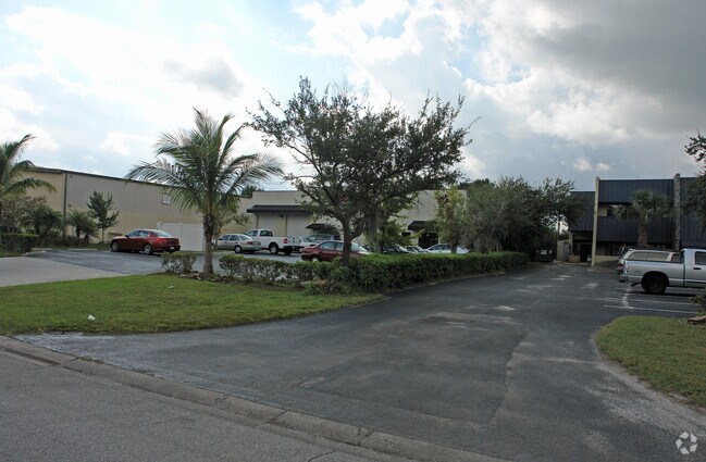
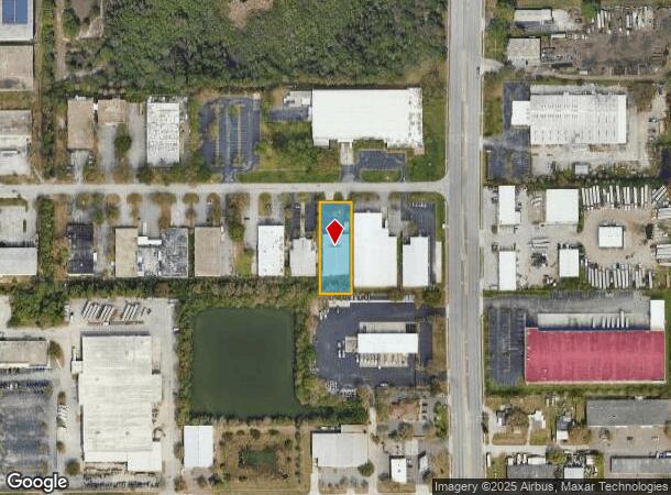
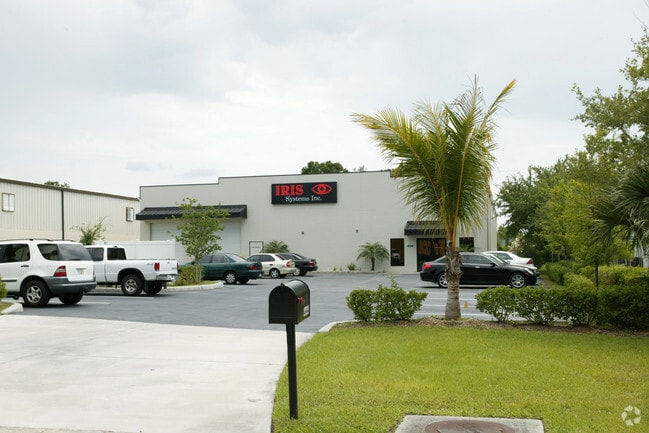
Property Record
4944 113Th Ave N, Clearwater, FL 33760

NEARBY LISTINGS FOR SALE OR LEASE
Property Detail
4944 113Th Ave N
Tampa-St. Petersburg-Clearwater, FL
Mid County
16-30-16-57676-000-0390
MID COUNTY INDUSTRIAL CENTER LOT 39
Warehouse
Pinellas
X
Florida
12103C0202J
39
2024
0.66 AC
2025
South Pinellas
024512
Tampa/St Petersburg
10,000 SF
DEMOGRAPHICS near 4944 113Th Ave N
1 Mile
3 Mile
5 Mile
2024 Total Population
5,873
71,061
230,021
2029 Population
5,857
71,587
230,807
Pop Growth 2024-2029
(0.27%)
+ 0.74%
+ 0.34%
Average Age
45
44
44
2024 Total Households
2,615
31,587
105,189
HH Growth 2024-2029
(0.50%)
+ 0.73%
+ 0.22%
Median Household Inc
$55,763
$58,786
$56,399
Avg Household Size
2.10
2.10
2.10
2024 Avg HH Vehicles
2.00
2.00
2.00
Median Home Value
$230,000
$213,182
$211,377
Median Year Built
1976
1980
1977
Nearby Places
Map Layers
Map Styles
 Street
 Aerial
- Restaurants
- Banks
- Shops
- Fitness
- Groceries
PUBLIC TRANSPORTATION
AIRPORT
St Pete-Clearwater International
DRIVE
WALK
Distance
St Pete-Clearwater International
14 min
5.0 mi
Tampa International
DRIVE
WALK
Distance
Tampa International
26 min
15.9 mi
Freight Ports
Port of Tampa Bay
DRIVE
WALK
Distance
Port of Tampa Bay
35 min
21.3 mi
Nearby Properties
Address
Land Use
TOTAL SIZE
Lot Size
Zoning
Address
Land Use
TOTAL SIZE
Lot Size
Zoning
795,890 SF
69.11 AC
M1
Address
Land Use
TOTAL SIZE
Lot Size
Zoning
130,544 SF
1,313.50 AC
PCAIRPOR
Address
Land Use
TOTAL SIZE
Lot Size
Zoning
1,160,631 SF
28.08 AC
Address
Land Use
TOTAL SIZE
Lot Size
Zoning
1,232,878 SF
12.64 AC
Address
Land Use
TOTAL SIZE
Lot Size
Zoning
428,587 SF
14.35 AC
Address
Land Use
TOTAL SIZE
Lot Size
Zoning
372,013 SF
10.10 AC
Address
Land Use
TOTAL SIZE
Lot Size
Zoning
466,420 SF
2.60 AC
Address
Land Use
TOTAL SIZE
Lot Size
Zoning
447,664 SF
34.44 AC
Address
Land Use
TOTAL SIZE
Lot Size
Zoning
171,420 SF
300.24 AC
M1
Address
Land Use
TOTAL SIZE
Lot Size
Zoning
350,604 SF
13.21 AC
Address
Land Use
TOTAL SIZE
Lot Size
Zoning
429,226 SF
0.85 AC
Address
Land Use
TOTAL SIZE
Lot Size
Zoning
416,482 SF
14.93 AC
Address
Land Use
TOTAL SIZE
Lot Size
Zoning
346,420 SF
17.95 AC
Address
Land Use
TOTAL SIZE
Lot Size
Zoning
372,436 SF
22.30 AC
Address
Land Use
TOTAL SIZE
Lot Size
Zoning
382,389 SF
13.62 AC
Address
Land Use
TOTAL SIZE
Lot Size
Zoning
404,063 SF
12.98 AC
Address
Land Use
TOTAL SIZE
Lot Size
Zoning
404,899 SF
35.35 AC
Address
Land Use
TOTAL SIZE
Lot Size
Zoning
401,627 SF
0.66 AC
Address
Land Use
TOTAL SIZE
Lot Size
Zoning
358,681 SF
11.70 AC
Address
Land Use
TOTAL SIZE
Lot Size
Zoning
240,736 SF
58.40 AC
Address
Land Use
TOTAL SIZE
Lot Size
Zoning
402,681 SF
18.40 AC
Address
Land Use
TOTAL SIZE
Lot Size
Zoning
255,548 SF
21.69 AC
RPD10
Address
Land Use
TOTAL SIZE
Lot Size
Zoning
364,675 SF
66.40 AC
AE
Address
Land Use
TOTAL SIZE
Lot Size
Zoning
311,000 SF
15.50 AC
Address
Land Use
TOTAL SIZE
Lot Size
Zoning
384,124 SF
25.78 AC
C3
Address
Land Use
TOTAL SIZE
Lot Size
Zoning
446,556 SF
14.95 AC
M1
Address
Land Use
TOTAL SIZE
Lot Size
Zoning
300,546 SF
6.49 AC
Address
Land Use
TOTAL SIZE
Lot Size
Zoning
362,618 SF
40.19 AC
R6
Address
Land Use
TOTAL SIZE
Lot Size
Zoning
266,396 SF
23.18 AC
Address
Land Use
TOTAL SIZE
Lot Size
Zoning
294,478 SF
44.79 AC
M1
The World's #1 Commercial Real Estate Marketplace
Connect with us
© 2025 CoStar Group
The information above has been obtained from sources believed reliable. While we do not doubt its accuracy we have not verified it and make no guarantee, warranty or representation about it. It is your responsibility to independently confirm its accuracy and completeness. Any projections, opinions, assumptions, or estimates used are for example only and do not represent the current or future performance of the property. The value of this transaction to you depends on tax and other factors which should be evaluated by your tax, financial, and legal advisors. You and your advisors should conduct a careful, independent investigation of the property to determine to your satisfaction the suitability of the property for your needs.