Property Record
4949 Bullard Ave, New Orleans, LA 70128


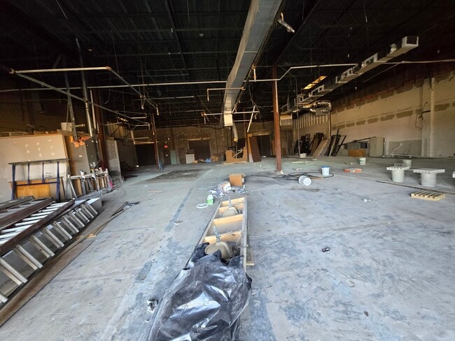
This Property Is For Sale
NEARBY LISTINGS FOR SALE OR LEASE
Property Detail
4949 Bullard Ave
New Orleans-Metairie, LA
Sec 31
3-9W-0-186-01
SEC 31 LOT G-1-A1 BULLARD & DWYER 555/551 X 372/366 4.657 ACRES E REC 1/ST STEEL/FR BR/V/WHSE NOTE
Officebuilding
Orleans
X
Louisiana
22087C0225D
g1a1
2025
4.66 AC
2025
New Orleans East
001748
New Orleans/Metairie/Kenner
33,012 SF
DEMOGRAPHICS near 4949 Bullard Ave
1 Mile
3 Mile
5 Mile
2024 Total Population
4,476
47,851
69,883
2029 Population
4,243
45,358
66,669
Pop Growth 2024-2029
(5.21%)
(5.21%)
(4.60%)
Average Age
42
39
39
2024 Total Households
1,574
17,328
25,190
HH Growth 2024-2029
(5.53%)
(5.51%)
(4.87%)
Median Household Inc
$56,153
$35,594
$34,180
Avg Household Size
2.70
2.60
2.70
2024 Avg HH Vehicles
2.00
1.00
1.00
Median Home Value
$199,820
$177,369
$176,932
Median Year Built
1979
1978
1976
Nearby Places
Map Layers
Map Styles
 Street
 Aerial
- Restaurants
- Banks
- Shops
- Fitness
- Groceries
PUBLIC TRANSPORTATION
AIRPORT
Louis Armstrong New Orleans International
DRIVE
WALK
Distance
Louis Armstrong New Orleans International
32 min
21.7 mi
Nearby Properties
Address
Land Use
TOTAL SIZE
Lot Size
Zoning
Address
Land Use
TOTAL SIZE
Lot Size
Zoning
Address
Land Use
TOTAL SIZE
Lot Size
Zoning
286.90 AC
HI
Address
Land Use
TOTAL SIZE
Lot Size
Zoning
139.95 AC
Address
Land Use
TOTAL SIZE
Lot Size
Zoning
21.58 AC
C-3
Address
Land Use
TOTAL SIZE
Lot Size
Zoning
109,239 SF
5.77 AC
S-RS
Address
Land Use
TOTAL SIZE
Lot Size
Zoning
115,600 SF
16.96 AC
S-B2
Address
Land Use
TOTAL SIZE
Lot Size
Zoning
42.84 AC
HI
Address
Land Use
TOTAL SIZE
Lot Size
Zoning
95,308 SF
16.36 AC
S-RS
Address
Land Use
TOTAL SIZE
Lot Size
Zoning
99,015 SF
6.99 AC
S-RS
Address
Land Use
TOTAL SIZE
Lot Size
Zoning
13,302 SF
53.89 AC
OS-R
Address
Land Use
TOTAL SIZE
Lot Size
Zoning
9.27 AC
S-B2
Address
Land Use
TOTAL SIZE
Lot Size
Zoning
20.58 AC
S-RS
Address
Land Use
TOTAL SIZE
Lot Size
Zoning
42.84 AC
HI
Address
Land Use
TOTAL SIZE
Lot Size
Zoning
179,095 SF
18.13 AC
C-3
Address
Land Use
TOTAL SIZE
Lot Size
Zoning
205,380 SF
16.49 AC
MS
Address
Land Use
TOTAL SIZE
Lot Size
Zoning
13,563 SF
81.46 AC
OS-R
Address
Land Use
TOTAL SIZE
Lot Size
Zoning
33.59 AC
S-RS
Address
Land Use
TOTAL SIZE
Lot Size
Zoning
19.84 AC
BIP
Address
Land Use
TOTAL SIZE
Lot Size
Zoning
280,168 SF
11.47 AC
S-RM2
Address
Land Use
TOTAL SIZE
Lot Size
Zoning
4.09 AC
S-RD
Address
Land Use
TOTAL SIZE
Lot Size
Zoning
147,600 SF
14.18 AC
C-3
Address
Land Use
TOTAL SIZE
Lot Size
Zoning
265,000 SF
11.93 AC
S-RM2
Address
Land Use
TOTAL SIZE
Lot Size
Zoning
42.84 AC
HI
Address
Land Use
TOTAL SIZE
Lot Size
Zoning
202,568 SF
1 AC
Address
Land Use
TOTAL SIZE
Lot Size
Zoning
65,184 SF
1.73 AC
C-2
Address
Land Use
TOTAL SIZE
Lot Size
Zoning
1.05 AC
C-3
Address
Land Use
TOTAL SIZE
Lot Size
Zoning
3.11 AC
S-B2
Address
Land Use
TOTAL SIZE
Lot Size
Zoning
346,636 SF
6.94 AC
C-3
Address
Land Use
TOTAL SIZE
Lot Size
Zoning
347,544 SF
16.54 AC
S-RM2
Address
Land Use
TOTAL SIZE
Lot Size
Zoning
133,204 SF
5.46 AC
S-RM2
The World's #1 Commercial Real Estate Marketplace
Connect with us
© 2026 CoStar Group
The information above has been obtained from sources believed reliable. While we do not doubt its accuracy we have not verified it and make no guarantee, warranty or representation about it. It is your responsibility to independently confirm its accuracy and completeness. Any projections, opinions, assumptions, or estimates used are for example only and do not represent the current or future performance of the property. The value of this transaction to you depends on tax and other factors which should be evaluated by your tax, financial, and legal advisors. You and your advisors should conduct a careful, independent investigation of the property to determine to your satisfaction the suitability of the property for your needs.