Property Record
495 Bluff Dr, Saint Louis, MO 63137
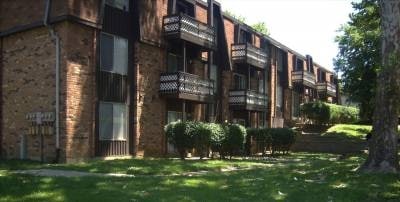

This Property Is For Sale
NEARBY LISTINGS FOR SALE OR LEASE
Property Detail
495 Bluff Dr
St. Louis, MO-IL
Riverview Gardens
12E-54-0382
RIVERVIEW GARDENS LOT 352
Apartment
St. Louis
X
Missouri
29189C0227K
352
2024
44 SF
2025
Riverview
210300
St. Louis
16,744 SF
DEMOGRAPHICS near 495 Bluff Dr
1 Mile
3 Mile
5 Mile
2024 Total Population
7,801
61,024
169,681
2029 Population
7,870
60,917
169,176
Pop Growth 2024-2029
+ 0.88%
(0.18%)
(0.30%)
Average Age
37
39
39
2024 Total Households
3,004
24,479
69,129
HH Growth 2024-2029
+ 0.73%
(0.34%)
(0.37%)
Median Household Inc
$44,160
$36,823
$39,350
Avg Household Size
2.50
2.40
2.40
2024 Avg HH Vehicles
1.00
1.00
1.00
Median Home Value
$69,970
$74,921
$84,297
Median Year Built
1957
1958
1958
Nearby Places
Map Layers
Map Styles
 Street
 Aerial
- Restaurants
- Banks
- Shops
- Fitness
- Groceries
PUBLIC TRANSPORTATION
COMMUTER RAIL
Um St. Louis South (Lambert Airport Shiloh-Scott - St. Louis MetroLink (MetroLink))
DRIVE
WALK
Distance
Um St. Louis South (Lambert Airport Shiloh-Scott - St. Louis MetroLink (MetroLink))
14 min
7.9 mi
Um St. Louis North (Lambert Airport Shiloh-Scott - St. Louis MetroLink (MetroLink))
DRIVE
WALK
Distance
Um St. Louis North (Lambert Airport Shiloh-Scott - St. Louis MetroLink (MetroLink))
14 min
8.3 mi
AIRPORT
St Louis Lambert International
DRIVE
WALK
Distance
St Louis Lambert International
15 min
8.3 mi
Scott AFB/Midamerica St Louis
DRIVE
WALK
Distance
Scott AFB/Midamerica St Louis
51 min
33.1 mi
Freight Ports
Port Milwaukee
DRIVE
WALK
Distance
Port Milwaukee
418 min
368.1 mi
Nearby Properties
Address
Land Use
TOTAL SIZE
Lot Size
Zoning
Address
Land Use
TOTAL SIZE
Lot Size
Zoning
1,925 SF
21.27 AC
C-8
Address
Land Use
TOTAL SIZE
Lot Size
Zoning
75.13 AC
R3
Address
Land Use
TOTAL SIZE
Lot Size
Zoning
205,268 SF
36.09 AC
88R-1
Address
Land Use
TOTAL SIZE
Lot Size
Zoning
48.23 AC
R3
Address
Land Use
TOTAL SIZE
Lot Size
Zoning
39.86 AC
A
Address
Land Use
TOTAL SIZE
Lot Size
Zoning
15.59 AC
R4
Address
Land Use
TOTAL SIZE
Lot Size
Zoning
77,616 SF
10.56 AC
C-8
Address
Land Use
TOTAL SIZE
Lot Size
Zoning
10,362 SF
19.03 AC
81R-2
Address
Land Use
TOTAL SIZE
Lot Size
Zoning
10 AC
R3
Address
Land Use
TOTAL SIZE
Lot Size
Zoning
64,372 SF
4.95 AC
C-8
Address
Land Use
TOTAL SIZE
Lot Size
Zoning
8.66 AC
R3
Address
Land Use
TOTAL SIZE
Lot Size
Zoning
3,256 SF
38.63 AC
88R-3
Address
Land Use
TOTAL SIZE
Lot Size
Zoning
30.81 AC
R3
Address
Land Use
TOTAL SIZE
Lot Size
Zoning
31,800 SF
17.34 AC
C-8
Address
Land Use
TOTAL SIZE
Lot Size
Zoning
88,466 SF
2.13 AC
31C-2S
Address
Land Use
TOTAL SIZE
Lot Size
Zoning
5.23 AC
31R-1
Address
Land Use
TOTAL SIZE
Lot Size
Zoning
69.24 AC
A
Address
Land Use
TOTAL SIZE
Lot Size
Zoning
5 AC
R5
Address
Land Use
TOTAL SIZE
Lot Size
Zoning
4.36 AC
NU
Address
Land Use
TOTAL SIZE
Lot Size
Zoning
6.37 AC
31R-1
Address
Land Use
TOTAL SIZE
Lot Size
Zoning
138,038 SF
7.03 AC
MI
Address
Land Use
TOTAL SIZE
Lot Size
Zoning
5 AC
88R-3
Address
Land Use
TOTAL SIZE
Lot Size
Zoning
6,915 SF
8.20 AC
88M-2
Address
Land Use
TOTAL SIZE
Lot Size
Zoning
5.39 AC
R2
Address
Land Use
TOTAL SIZE
Lot Size
Zoning
3,384 SF
6.16 AC
R4
Address
Land Use
TOTAL SIZE
Lot Size
Zoning
5.93 AC
R5
Address
Land Use
TOTAL SIZE
Lot Size
Zoning
160,908 SF
7.99 AC
R6
Address
Land Use
TOTAL SIZE
Lot Size
Zoning
5.08 AC
88R-3
Address
Land Use
TOTAL SIZE
Lot Size
Zoning
110,868 SF
11.75 AC
88C-2
Address
Land Use
TOTAL SIZE
Lot Size
Zoning
2.48 AC
C-8
The World's #1 Commercial Real Estate Marketplace
Connect with us
© 2025 CoStar Group
The information above has been obtained from sources believed reliable. While we do not doubt its accuracy we have not verified it and make no guarantee, warranty or representation about it. It is your responsibility to independently confirm its accuracy and completeness. Any projections, opinions, assumptions, or estimates used are for example only and do not represent the current or future performance of the property. The value of this transaction to you depends on tax and other factors which should be evaluated by your tax, financial, and legal advisors. You and your advisors should conduct a careful, independent investigation of the property to determine to your satisfaction the suitability of the property for your needs.