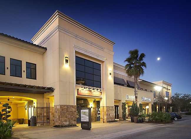
Property Record
495 Grand Blvd, Miramar Beach, FL 32550
NEARBY LISTINGS FOR SALE OR LEASE
Property Detail
495 Grand Blvd
26-2S-21-42000-001-0050
(PRCL B) DESC AS: BEG AT INTERSECTION WEST LINE SEC 25 & NLY ROW ST RD 30, THENCE ON NLY ROW N 79 DEG 3029W 244.10FT, N 76 DEG 12 20W 96.95FT,DPRT ROW N 02 DEG 2327E 696.35FT, S 87 DEG 3710E 558.31FT, S 02 DEG 01 45W 793.10FT TO NLY ROW, N 76 DEG 220
Regionalshoppingcenterormallwithanchorstore
Walton
X
Florida
12131C0539H
111
2025
11.87 AC
2025
Fort Walton Beach
950607
Other Market Areas
218,504 SF
Crestview-Fort Walton Beach-Destin, FL
DEMOGRAPHICS near 495 Grand Blvd
1 Mile
3 Mile
5 Mile
2024 Total Population
3,358
15,083
25,067
2029 Population
4,418
19,535
32,500
Pop Growth 2024-2029
+ 31.57%
+ 29.52%
+ 29.65%
Average Age
52
48
48
2024 Total Households
1,505
6,702
11,280
HH Growth 2024-2029
+ 32.76%
+ 30.75%
+ 30.86%
Median Household Inc
$85,218
$85,065
$73,665
Avg Household Size
2.10
2.20
2.20
2024 Avg HH Vehicles
2.00
2.00
2.00
Median Home Value
$641,666
$483,239
$471,903
Median Year Built
2001
2001
2001
Nearby Places
Map Layers
Map Styles
 Street
 Aerial
- Restaurants
- Banks
- Shops
- Fitness
- Groceries
PUBLIC TRANSPORTATION
AIRPORT
Eglin AFB/Destin-Ft Walton Beach
DRIVE
WALK
Distance
Eglin AFB/Destin-Ft Walton Beach
45 min
33.9 mi
Freight Ports
Port of Panama City
DRIVE
WALK
Distance
Port of Panama City
1 min
37.4 mi
SALE & LEASE HISTORY
LISTING DATE
SALE/LEASE

Oct 09, 2018
For Lease
Nearby Properties
Address
Land Use
TOTAL SIZE
Lot Size
Zoning
Address
Land Use
TOTAL SIZE
Lot Size
Zoning
437,780 SF
9.40 AC
SD
Address
Land Use
TOTAL SIZE
Lot Size
Zoning
429,135 SF
23.38 AC
HWY 98
Address
Land Use
TOTAL SIZE
Lot Size
Zoning
267,405 SF
1.54 AC
Address
Land Use
TOTAL SIZE
Lot Size
Zoning
269,575 SF
5.60 AC
SD
Address
Land Use
TOTAL SIZE
Lot Size
Zoning
399,449 SF
32.23 AC
SMNBHD
Address
Land Use
TOTAL SIZE
Lot Size
Zoning
164,747 SF
18.79 AC
Address
Land Use
TOTAL SIZE
Lot Size
Zoning
195,860 SF
14.03 AC
HWY 98
Address
Land Use
TOTAL SIZE
Lot Size
Zoning
182,539 SF
2.60 AC
SD
Address
Land Use
TOTAL SIZE
Lot Size
Zoning
138,905 SF
4.01 AC
Address
Land Use
TOTAL SIZE
Lot Size
Zoning
205,627 SF
34.20 AC
HWY 98
Address
Land Use
TOTAL SIZE
Lot Size
Zoning
115,433 SF
0.96 AC
Address
Land Use
TOTAL SIZE
Lot Size
Zoning
118,963 SF
7.58 AC
Address
Land Use
TOTAL SIZE
Lot Size
Zoning
74,662 SF
6.02 AC
HWY 98
Address
Land Use
TOTAL SIZE
Lot Size
Zoning
97,373 SF
12.83 AC
HWY 98
Address
Land Use
TOTAL SIZE
Lot Size
Zoning
135,599 SF
1.21 AC
HWY 98
Address
Land Use
TOTAL SIZE
Lot Size
Zoning
9,534 SF
12.45 AC
BAYS
Address
Land Use
TOTAL SIZE
Lot Size
Zoning
65,340 SF
1.01 AC
CCMU
Address
Land Use
TOTAL SIZE
Lot Size
Zoning
87,959 SF
2.76 AC
HWY 98
Address
Land Use
TOTAL SIZE
Lot Size
Zoning
126,494 SF
7.99 AC
VMU
Address
Land Use
TOTAL SIZE
Lot Size
Zoning
70,631 SF
75.50 AC
Address
Land Use
TOTAL SIZE
Lot Size
Zoning
63,106 SF
7.73 AC
HWY 98
Address
Land Use
TOTAL SIZE
Lot Size
Zoning
1,500 SF
241.13 AC
Address
Land Use
TOTAL SIZE
Lot Size
Zoning
18,731 SF
10.15 AC
GULFFR
Address
Land Use
TOTAL SIZE
Lot Size
Zoning
67,482 SF
5.77 AC
Address
Land Use
TOTAL SIZE
Lot Size
Zoning
71,106 SF
1 AC
Address
Land Use
TOTAL SIZE
Lot Size
Zoning
1.81 AC
GULFFR
Address
Land Use
TOTAL SIZE
Lot Size
Zoning
67,668 SF
1.56 AC
Address
Land Use
TOTAL SIZE
Lot Size
Zoning
78,285 SF
10.07 AC
HWY 98
Address
Land Use
TOTAL SIZE
Lot Size
Zoning
68,849 SF
6.75 AC
HWY 98
The World's #1 Commercial Real Estate Marketplace
Connect with us
© 2026 CoStar Group
The information above has been obtained from sources believed reliable. While we do not doubt its accuracy we have not verified it and make no guarantee, warranty or representation about it. It is your responsibility to independently confirm its accuracy and completeness. Any projections, opinions, assumptions, or estimates used are for example only and do not represent the current or future performance of the property. The value of this transaction to you depends on tax and other factors which should be evaluated by your tax, financial, and legal advisors. You and your advisors should conduct a careful, independent investigation of the property to determine to your satisfaction the suitability of the property for your needs.