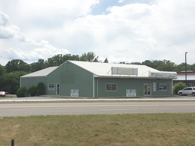
Property Record
495 Highway 10 E, Detroit Lakes, MN 56501

Save to a Folder
{{folder.Name}}
{{folder.ListingIds.length}} Properties
{{folder.ListingIds.length}} Property
Create a New Folder
Property Detail
495 Highway 10 E
Detroit Lakes, MN
CHERRY'S SUBDIV D L BLOCK 007 PT OF BLKS 3, 6, & 7; BEG 143.49' SELY OF NW COR BLK 3, TH S 188.43' TO OAK ST, E TO JACKSON
R490753000
BECKER
Officebuilding
Minnesota
2026
0.42 AC
2025
Minnesota North Area
450600
Other Market Areas
5,350 SF
NEARBY LISTINGS FOR SALE OR LEASE
-
-
View all Detroit Lakes listings for sale on LoopNet.com
DEMOGRAPHICS near 495 Highway 10 E
1 mile
3 mile
5 mile
2025 Total Population
4,905
9,718
13,966
2030 Population
4,786
9,556
13,896
Pop Growth 2025-2030
(2.43%)
(1.67%)
(0.50%)
Average Age
41
41
42
2025 Total Households
2,267
4,286
5,979
HH Growth 2025-2030
(2.65%)
(1.84%)
(0.69%)
Median Household Inc
$47,966
$60,693
$67,877
Avg Household Size
2.00
2.20
2.20
2025 Avg HH Vehicles
2.00
2.00
2.00
Median Home Value
$213,850
$268,372
$309,102
Median Year Built
1968
1973
1976
Nearby Places
Map Layers
Map Styles
 Street
 Aerial
Layers
 Traffic
 Biking
Places
Listings with unknown addresses are not visible on the map
- Restaurants
- Banks
- Shops
- Fitness
- Groceries
PUBLIC TRANSPORTATION
COMMUTER RAIL
Drive
Walk
Distance
1 min
16 min
0.8 mi
SALE & LEASE HISTORY
LISTING DATE
SALE/LEASE

Sep 25, 2016
For Lease
Sep 23, 2016
For Sale
Nov 23, 2016
For Sale
Mar 28, 2017
For Sale
Nearby Properties
Address
Land Use
TOTAL SIZE
Lot Size
Zoning
Address
Land Use
TOTAL SIZE
Lot Size
Zoning
154,064 SF
45.01 AC
Address
Land Use
TOTAL SIZE
Lot Size
Zoning
54,609 SF
9.29 AC
Address
Land Use
TOTAL SIZE
Lot Size
Zoning
2,800 SF
20.97 AC
Address
Land Use
TOTAL SIZE
Lot Size
Zoning
7,154 SF
38.57 AC
Address
Land Use
TOTAL SIZE
Lot Size
Zoning
4,800 SF
164.90 AC
Address
Land Use
TOTAL SIZE
Lot Size
Zoning
112,902 SF
3.13 AC
Address
Land Use
TOTAL SIZE
Lot Size
Zoning
4,368 SF
0.43 AC
Address
Land Use
TOTAL SIZE
Lot Size
Zoning
27,720 SF
21.13 AC
Address
Land Use
TOTAL SIZE
Lot Size
Zoning
2,400 SF
0.08 AC
Address
Land Use
TOTAL SIZE
Lot Size
Zoning
163,994 SF
28.08 AC
Address
Land Use
TOTAL SIZE
Lot Size
Zoning
11,177 SF
4.40 AC
Address
Land Use
TOTAL SIZE
Lot Size
Zoning
79,780 SF
7.95 AC
Address
Land Use
TOTAL SIZE
Lot Size
Zoning
67,125 SF
2.49 AC
Address
Land Use
TOTAL SIZE
Lot Size
Zoning
52,804 SF
11.76 AC
Address
Land Use
TOTAL SIZE
Lot Size
Zoning
7,882 SF
41.38 AC
Address
Land Use
TOTAL SIZE
Lot Size
Zoning
9,600 SF
21 AC
Address
Land Use
TOTAL SIZE
Lot Size
Zoning
58,047 SF
12.18 AC
Address
Land Use
TOTAL SIZE
Lot Size
Zoning
51,323 SF
1.86 AC
Address
Land Use
TOTAL SIZE
Lot Size
Zoning
27,556 SF
1.65 AC
Address
Land Use
TOTAL SIZE
Lot Size
Zoning
10,800 SF
18.17 AC
Address
Land Use
TOTAL SIZE
Lot Size
Zoning
36,948 SF
0.53 AC
Address
Land Use
TOTAL SIZE
Lot Size
Zoning
41,324 SF
1.51 AC
Address
Land Use
TOTAL SIZE
Lot Size
Zoning
44,627 SF
2.18 AC
Address
Land Use
TOTAL SIZE
Lot Size
Zoning
90,240 SF
2.75 AC
Address
Land Use
TOTAL SIZE
Lot Size
Zoning
61,111 SF
5.20 AC
Address
Land Use
TOTAL SIZE
Lot Size
Zoning
4,640 SF
6.21 AC
Address
Land Use
TOTAL SIZE
Lot Size
Zoning
104,365 SF
3.79 AC
Address
Land Use
TOTAL SIZE
Lot Size
Zoning
59,334 SF
2.77 AC
Address
Land Use
TOTAL SIZE
Lot Size
Zoning
126,181 SF
2.50 AC
Address
Land Use
TOTAL SIZE
Lot Size
Zoning
70,584 SF
1.46 AC
The World's #1 Commercial Real Estate Marketplace
Connect with us
© 2026 CoStar Group
The information above has been obtained from sources believed reliable. While we do not doubt its accuracy we have not verified it and make no guarantee, warranty or representation about it. It is your responsibility to independently confirm its accuracy and completeness. Any projections, opinions, assumptions, or estimates used are for example only and do not represent the current or future performance of the property. The value of this transaction to you depends on tax and other factors which should be evaluated by your tax, financial, and legal advisors. You and your advisors should conduct a careful, independent investigation of the property to determine to your satisfaction the suitability of the property for your needs.