Property Record
495 King St, Charleston, SC 29403
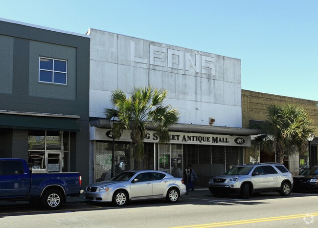


Property Detail
495 King St
Charleston-North Charleston, SC
DESCRIPTION -495 497 KING SITE NAME -& 497
460-12-02-087
Charleston
Commercialnec
South Carolina
C and X Area of minimal flood hazard, usually depicted on FIRMs as above the 500-year flood level.
0.12 AC
2025
Downtown Charleston
2024
Charleston/N Charleston
000700
NEARBY LISTINGS FOR SALE OR LEASE
DEMOGRAPHICS near 495 King St
1 mile
3 mile
5 mile
2025 Total Population
25,064
51,218
133,166
2030 Population
26,880
54,355
139,754
Pop Growth 2025-2030
+ 7.25%
+ 6.12%
+ 4.95%
Average Age
35
37
40
2025 Total Households
11,928
23,500
59,275
HH Growth 2025-2030
+ 7.67%
+ 6.47%
+ 5.15%
Median Household Inc
$69,892
$85,453
$93,056
Avg Household Size
1.90
2.00
2.10
2025 Avg HH Vehicles
1.00
1.00
2.00
Median Home Value
$820,812
$804,720
$654,491
Median Year Built
1960
1963
1976
Nearby Places
Map Layers
Map Styles
 Street
 Aerial
Layers
 Traffic
 Biking
Places
Listings with unknown addresses are not visible on the map
- Restaurants
- Banks
- Shops
- Fitness
- Groceries
PUBLIC TRANSPORTATION
COMMUTER RAIL
Charleston Amtrak Station (Palmetto - Amtrak, Silver Meteor - Amtrak)
Drive
Walk
Distance
Charleston Amtrak Station (Palmetto - Amtrak, Silver Meteor - Amtrak)
9 min
7.3 mi
AIRPORT
Charleston AFB/International
Drive
Walk
Distance
Charleston AFB/International
20 min
13.8 mi
Freight Ports
Columbus Street Terminal
Drive
Walk
Distance
Columbus Street Terminal
1 min
0.8 mi
SALE & LEASE HISTORY
LISTING DATE
SALE/LEASE

Aug 04, 2025
For Sale
Nearby Properties
Address
Land Use
TOTAL SIZE
Lot Size
Zoning
Address
Land Use
TOTAL SIZE
Lot Size
Zoning
79,990 SF
9.22 AC
Address
Land Use
TOTAL SIZE
Lot Size
Zoning
2,592 SF
13.64 AC
Address
Land Use
TOTAL SIZE
Lot Size
Zoning
Address
Land Use
TOTAL SIZE
Lot Size
Zoning
0.62 AC
Address
Land Use
TOTAL SIZE
Lot Size
Zoning
39,150 SF
7.76 AC
Address
Land Use
TOTAL SIZE
Lot Size
Zoning
80,044 SF
2.48 AC
Address
Land Use
TOTAL SIZE
Lot Size
Zoning
85,408 SF
9.39 AC
Address
Land Use
TOTAL SIZE
Lot Size
Zoning
22,620 SF
12.23 AC
Address
Land Use
TOTAL SIZE
Lot Size
Zoning
66,136 SF
1.88 AC
Address
Land Use
TOTAL SIZE
Lot Size
Zoning
8,472 SF
9.83 AC
Address
Land Use
TOTAL SIZE
Lot Size
Zoning
8,472 SF
9.84 AC
Address
Land Use
TOTAL SIZE
Lot Size
Zoning
Address
Land Use
TOTAL SIZE
Lot Size
Zoning
1,435 SF
1.98 AC
Address
Land Use
TOTAL SIZE
Lot Size
Zoning
6.11 AC
Address
Land Use
TOTAL SIZE
Lot Size
Zoning
17,459 SF
4.16 AC
Address
Land Use
TOTAL SIZE
Lot Size
Zoning
8,714 SF
1.60 AC
Address
Land Use
TOTAL SIZE
Lot Size
Zoning
Address
Land Use
TOTAL SIZE
Lot Size
Zoning
1,282 SF
8.42 AC
Address
Land Use
TOTAL SIZE
Lot Size
Zoning
Address
Land Use
TOTAL SIZE
Lot Size
Zoning
Address
Land Use
TOTAL SIZE
Lot Size
Zoning
5,733 SF
0.10 AC
Address
Land Use
TOTAL SIZE
Lot Size
Zoning
43,934 SF
1.50 AC
Address
Land Use
TOTAL SIZE
Lot Size
Zoning
14,240 SF
3.50 AC
Address
Land Use
TOTAL SIZE
Lot Size
Zoning
8,740 SF
0.58 AC
Address
Land Use
TOTAL SIZE
Lot Size
Zoning
1,150 SF
Address
Land Use
TOTAL SIZE
Lot Size
Zoning
24,320 SF
1.31 AC
Address
Land Use
TOTAL SIZE
Lot Size
Zoning
29,910 SF
2.82 AC
Address
Land Use
TOTAL SIZE
Lot Size
Zoning
41,070 SF
0.61 AC
Address
Land Use
TOTAL SIZE
Lot Size
Zoning
Address
Land Use
TOTAL SIZE
Lot Size
Zoning
22,825 SF
4.36 AC
The World's #1 Commercial Real Estate Marketplace
Connect with us
© 2026 CoStar Group
The information above has been obtained from sources believed reliable. While we do not doubt its accuracy we have not verified it and make no guarantee, warranty or representation about it. It is your responsibility to independently confirm its accuracy and completeness. Any projections, opinions, assumptions, or estimates used are for example only and do not represent the current or future performance of the property. The value of this transaction to you depends on tax and other factors which should be evaluated by your tax, financial, and legal advisors. You and your advisors should conduct a careful, independent investigation of the property to determine to your satisfaction the suitability of the property for your needs.