Property Record
495 N Marks Ave, Fresno, CA 93706


Save to a Folder
{{folder.Name}}
{{folder.ListingIds.length}} Properties
{{folder.ListingIds.length}} Property
Create a New Folder
Property Detail
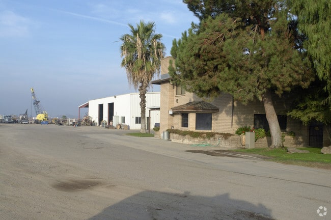
495 N Marks Ave
326-060-34S
495 N MARKS FR
Warehouse
Fresno
M2
California
B and X Area of moderate flood hazard, usually the area between the limits of the 100-year and 500-year floods.
26.92 AC
2025
Southwest Fresno
2025
Fresno
008600
Fresno, CA
15,222 SF
NEARBY LISTINGS FOR SALE OR LEASE
DEMOGRAPHICS near 495 N Marks Ave
1 mile
3 mile
5 mile
2025 Total Population
2,808
85,258
235,173
2030 Population
2,840
85,900
237,577
Pop Growth 2025-2030
+ 1.14%
+ 0.75%
+ 1.02%
Average Age
36
35
35
2025 Total Households
835
26,768
73,239
HH Growth 2025-2030
+ 1.08%
+ 0.80%
+ 1.07%
Median Household Inc
$35,855
$54,861
$55,642
Avg Household Size
3.30
3.00
3.00
2025 Avg HH Vehicles
2.00
2.00
2.00
Median Home Value
$240,000
$310,693
$319,270
Median Year Built
1971
1967
1968
Nearby Places
Map Layers
Map Styles
 Street
 Aerial
Layers
 Traffic
 Biking
Places
Listings with unknown addresses are not visible on the map
- Restaurants
- Banks
- Shops
- Fitness
- Groceries
PUBLIC TRANSPORTATION
AIRPORT
Fresno Yosemite International
Drive
Walk
Distance
Fresno Yosemite International
15 min
9.3 mi
Nearby Properties
Address
Land Use
TOTAL SIZE
Lot Size
Zoning
Address
Land Use
TOTAL SIZE
Lot Size
Zoning
141,959 SF
35.39 AC
SPLIT
Address
Land Use
TOTAL SIZE
Lot Size
Zoning
61,575 SF
3.50 AC
SPLIT
Address
Land Use
TOTAL SIZE
Lot Size
Zoning
96,012 SF
1.33 AC
C4
Address
Land Use
TOTAL SIZE
Lot Size
Zoning
96,012 SF
0.60 AC
C4
Address
Land Use
TOTAL SIZE
Lot Size
Zoning
159,822 SF
9.67 AC
R2
Address
Land Use
TOTAL SIZE
Lot Size
Zoning
71,384 SF
6.34 AC
IL
Address
Land Use
TOTAL SIZE
Lot Size
Zoning
106,740 SF
63.59 AC
AE20
Address
Land Use
TOTAL SIZE
Lot Size
Zoning
32,156 SF
2.60 AC
C6
Address
Land Use
TOTAL SIZE
Lot Size
Zoning
103,088 SF
5.41 AC
R3
Address
Land Use
TOTAL SIZE
Lot Size
Zoning
113,419 SF
1.26 AC
C4
Address
Land Use
TOTAL SIZE
Lot Size
Zoning
88,718 SF
1.64 AC
C4
Address
Land Use
TOTAL SIZE
Lot Size
Zoning
121,411 SF
0.60 AC
DTC
Address
Land Use
TOTAL SIZE
Lot Size
Zoning
88,345 SF
5.18 AC
R3
Address
Land Use
TOTAL SIZE
Lot Size
Zoning
43,002 SF
1.34 AC
DTN
Address
Land Use
TOTAL SIZE
Lot Size
Zoning
95,874 SF
5.46 AC
R3
Address
Land Use
TOTAL SIZE
Lot Size
Zoning
98,542 SF
6.94 AC
R4
Address
Land Use
TOTAL SIZE
Lot Size
Zoning
37,430 SF
0.34 AC
DTC
Address
Land Use
TOTAL SIZE
Lot Size
Zoning
84,309 SF
3.97 AC
R3
Address
Land Use
TOTAL SIZE
Lot Size
Zoning
53,928 SF
1.19 AC
C4
Address
Land Use
TOTAL SIZE
Lot Size
Zoning
74,212 SF
4.38 AC
R3
Address
Land Use
TOTAL SIZE
Lot Size
Zoning
86,559 SF
5.40 AC
R3
Address
Land Use
TOTAL SIZE
Lot Size
Zoning
57,792 SF
0.60 AC
DTN
Address
Land Use
TOTAL SIZE
Lot Size
Zoning
63,689 SF
1.95 AC
DTN
Address
Land Use
TOTAL SIZE
Lot Size
Zoning
127,758 SF
7.82 AC
R3
Address
Land Use
TOTAL SIZE
Lot Size
Zoning
26,962 SF
2 AC
M1
Address
Land Use
TOTAL SIZE
Lot Size
Zoning
68,697 SF
5.17 AC
R3
Address
Land Use
TOTAL SIZE
Lot Size
Zoning
45,376 SF
4.47 AC
CM
Address
Land Use
TOTAL SIZE
Lot Size
Zoning
23,616 SF
5.22 AC
SPLIT
Address
Land Use
TOTAL SIZE
Lot Size
Zoning
115,347 SF
2.17 AC
C4
Address
Land Use
TOTAL SIZE
Lot Size
Zoning
63,250 SF
3.67 AC
C6
The World's #1 Commercial Real Estate Marketplace
Connect with us
© 2026 CoStar Group
The information above has been obtained from sources believed reliable. While we do not doubt its accuracy we have not verified it and make no guarantee, warranty or representation about it. It is your responsibility to independently confirm its accuracy and completeness. Any projections, opinions, assumptions, or estimates used are for example only and do not represent the current or future performance of the property. The value of this transaction to you depends on tax and other factors which should be evaluated by your tax, financial, and legal advisors. You and your advisors should conduct a careful, independent investigation of the property to determine to your satisfaction the suitability of the property for your needs.