Property Record
495 Route 16, Ossipee, NH 03864
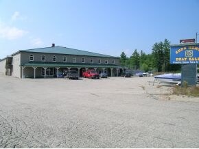

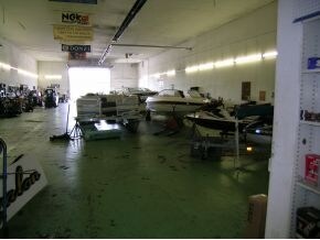
Property Detail
495 Route 16
Commercialbuilding
CARROLL
CORCOR
New Hampshire
B and X Area of moderate flood hazard, usually the area between the limits of the 100-year and 500-year floods.
16000
2025
22.13 AC
2025
Concord/New Hampshire North Area
955902
Other Market Areas
21,308 SF
OSSI-000266-000000-016000
NEARBY LISTINGS FOR SALE OR LEASE
-
-
View all Ossipee listings for sale on LoopNet.com
DEMOGRAPHICS near 495 Route 16
1 mile
3 mile
5 mile
2025 Total Population
149
1,355
4,528
2030 Population
150
1,363
4,657
Pop Growth 2025-2030
+ 0.67%
+ 0.59%
+ 2.85%
Average Age
49
48
47
2025 Total Households
57
533
1,840
HH Growth 2025-2030
+ 1.75%
+ 0.38%
+ 2.77%
Median Household Inc
$58,181
$61,912
$71,913
Avg Household Size
2.30
2.30
2.30
2025 Avg HH Vehicles
2.00
2.00
2.00
Median Home Value
$279,999
$311,058
$371,725
Median Year Built
1981
1979
1982
Nearby Places
Map Layers
Map Styles
 Street
 Aerial
Layers
 Traffic
 Biking
Places
Listings with unknown addresses are not visible on the map
- Restaurants
- Banks
- Shops
- Fitness
- Groceries
Nearby Properties
Address
Land Use
TOTAL SIZE
Lot Size
Zoning
Address
Land Use
TOTAL SIZE
Lot Size
Zoning
45 AC
RUR
Address
Land Use
TOTAL SIZE
Lot Size
Zoning
Address
Land Use
TOTAL SIZE
Lot Size
Zoning
34,137 SF
6.90 AC
RUR
Address
Land Use
TOTAL SIZE
Lot Size
Zoning
Address
Land Use
TOTAL SIZE
Lot Size
Zoning
1,318.01 AC
C/I GR
Address
Land Use
TOTAL SIZE
Lot Size
Zoning
124.42 AC
WF DAN
Address
Land Use
TOTAL SIZE
Lot Size
Zoning
18,662 SF
3.35 AC
C/I GR
Address
Land Use
TOTAL SIZE
Lot Size
Zoning
4.66 AC
C/I GR
Address
Land Use
TOTAL SIZE
Lot Size
Zoning
44,406 SF
3.17 AC
C/I GR
Address
Land Use
TOTAL SIZE
Lot Size
Zoning
46,853 SF
2.50 AC
RSC
Address
Land Use
TOTAL SIZE
Lot Size
Zoning
20,619 SF
10.86 AC
RUR
Address
Land Use
TOTAL SIZE
Lot Size
Zoning
66 AC
RUR
Address
Land Use
TOTAL SIZE
Lot Size
Zoning
41 AC
CORCOR
Address
Land Use
TOTAL SIZE
Lot Size
Zoning
6,747 SF
31.05 AC
NORTH
Address
Land Use
TOTAL SIZE
Lot Size
Zoning
8.09 AC
COM
Address
Land Use
TOTAL SIZE
Lot Size
Zoning
10,407 SF
1.84 AC
COM
Address
Land Use
TOTAL SIZE
Lot Size
Zoning
12,787 SF
15.16 AC
CORCOR
Address
Land Use
TOTAL SIZE
Lot Size
Zoning
1,340 SF
7.19 AC
COM
Address
Land Use
TOTAL SIZE
Lot Size
Zoning
15.09 AC
CORCOR
Address
Land Use
TOTAL SIZE
Lot Size
Zoning
12,978 SF
14.90 AC
COM
Address
Land Use
TOTAL SIZE
Lot Size
Zoning
11,209 SF
75 AC
RSC
Address
Land Use
TOTAL SIZE
Lot Size
Zoning
9,404 SF
1.60 AC
COM
Address
Land Use
TOTAL SIZE
Lot Size
Zoning
10,219 SF
5.88 AC
CORCOR
Address
Land Use
TOTAL SIZE
Lot Size
Zoning
672 SF
134.70 AC
C/I GR
Address
Land Use
TOTAL SIZE
Lot Size
Zoning
17.50 AC
COM
Address
Land Use
TOTAL SIZE
Lot Size
Zoning
49 AC
CORCOR
Address
Land Use
TOTAL SIZE
Lot Size
Zoning
7,544 SF
1.76 AC
COM
Address
Land Use
TOTAL SIZE
Lot Size
Zoning
6.95 AC
CORCOR
Address
Land Use
TOTAL SIZE
Lot Size
Zoning
14.15 AC
CORCOR
The World's #1 Commercial Real Estate Marketplace
Connect with us
© 2026 CoStar Group
The information above has been obtained from sources believed reliable. While we do not doubt its accuracy we have not verified it and make no guarantee, warranty or representation about it. It is your responsibility to independently confirm its accuracy and completeness. Any projections, opinions, assumptions, or estimates used are for example only and do not represent the current or future performance of the property. The value of this transaction to you depends on tax and other factors which should be evaluated by your tax, financial, and legal advisors. You and your advisors should conduct a careful, independent investigation of the property to determine to your satisfaction the suitability of the property for your needs.