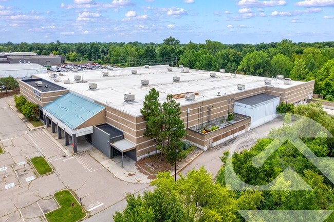
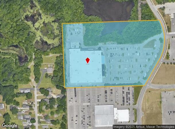
Property Record
495 Summit Dr, Waterford, MI 48328
Current Lease Availabilities
NEARBY LISTINGS FOR SALE OR LEASE
Property Detail
495 Summit Dr
13-24-451-015
T3N, R9E, SEC 24 PART OF SE 1/4 BEG AT S 1/4 COR, TH N 00-18-44 W 645.09 FT, TH N 89-50-01 E 969.43 FT, TH ALG CURVE TO
Warehouse
Oakland
X
Michigan
26125C0364F
14.09 AC
2024
Lakes Area
2025
Detroit
145900
Detroit-Warren-Dearborn, MI
110,526 SF
DEMOGRAPHICS near 495 Summit Dr
1 Mile
3 Mile
5 Mile
2024 Total Population
8,132
71,518
159,706
2029 Population
8,104
71,279
159,003
Pop Growth 2024-2029
(0.34%)
(0.33%)
(0.44%)
Average Age
41
41
40
2024 Total Households
3,722
30,237
66,402
HH Growth 2024-2029
(0.21%)
(0.39%)
(0.49%)
Median Household Inc
$56,636
$52,721
$58,039
Avg Household Size
2.10
2.20
2.30
2024 Avg HH Vehicles
2.00
2.00
2.00
Median Home Value
$151,255
$172,070
$202,936
Median Year Built
1969
1962
1968
Nearby Places
Map Layers
Map Styles
 Street
 Aerial
- Restaurants
- Banks
- Shops
- Fitness
- Groceries
PUBLIC TRANSPORTATION
COMMUTER RAIL
DRIVE
WALK
Distance
8 min
3.0 mi
AIRPORT
Bishop International
DRIVE
WALK
Distance
Bishop International
57 min
35.0 mi
Detroit Metro Wayne County
DRIVE
WALK
Distance
Detroit Metro Wayne County
64 min
40.6 mi
Windsor International
DRIVE
WALK
Distance
Windsor International
66 min
42.5 mi
Nearby Properties
Address
Land Use
TOTAL SIZE
Lot Size
Zoning
Address
Land Use
TOTAL SIZE
Lot Size
Zoning
481,186 SF
42.14 AC
AI
Address
Land Use
TOTAL SIZE
Lot Size
Zoning
1,771,589 SF
96.73 AC
Address
Land Use
TOTAL SIZE
Lot Size
Zoning
426,034 SF
24.99 AC
AI
Address
Land Use
TOTAL SIZE
Lot Size
Zoning
102,379 SF
28.20 AC
Address
Land Use
TOTAL SIZE
Lot Size
Zoning
79,263 SF
22.27 AC
Address
Land Use
TOTAL SIZE
Lot Size
Zoning
288,124 SF
15.76 AC
Address
Land Use
TOTAL SIZE
Lot Size
Zoning
130,414 SF
10.75 AC
AI
Address
Land Use
TOTAL SIZE
Lot Size
Zoning
145,872 SF
14.81 AC
AI
Address
Land Use
TOTAL SIZE
Lot Size
Zoning
87,560 SF
7.94 AC
BI
Address
Land Use
TOTAL SIZE
Lot Size
Zoning
157,589 SF
5.21 AC
Address
Land Use
TOTAL SIZE
Lot Size
Zoning
126,844 SF
3.20 AC
ME
Address
Land Use
TOTAL SIZE
Lot Size
Zoning
143,701 SF
9.85 AC
AI
Address
Land Use
TOTAL SIZE
Lot Size
Zoning
235,395 SF
Address
Land Use
TOTAL SIZE
Lot Size
Zoning
93,706 SF
1.13 AC
Address
Land Use
TOTAL SIZE
Lot Size
Zoning
93,555 SF
3.15 AC
AI
Address
Land Use
TOTAL SIZE
Lot Size
Zoning
64,053 SF
2.69 AC
Address
Land Use
TOTAL SIZE
Lot Size
Zoning
137,256 SF
14.97 AC
BI
Address
Land Use
TOTAL SIZE
Lot Size
Zoning
235,395 SF
Address
Land Use
TOTAL SIZE
Lot Size
Zoning
1,332,530 SF
95.81 AC
Address
Land Use
TOTAL SIZE
Lot Size
Zoning
211,861 SF
2.69 AC
BI
Address
Land Use
TOTAL SIZE
Lot Size
Zoning
80,600 SF
51.48 AC
Address
Land Use
TOTAL SIZE
Lot Size
Zoning
235,395 SF
37.19 AC
Address
Land Use
TOTAL SIZE
Lot Size
Zoning
235,395 SF
34.42 AC
Address
Land Use
TOTAL SIZE
Lot Size
Zoning
86,264 SF
7.85 AC
BI
Address
Land Use
TOTAL SIZE
Lot Size
Zoning
102,042 SF
7.07 AC
AI
Address
Land Use
TOTAL SIZE
Lot Size
Zoning
210,350 SF
32.38 AC
BI
Address
Land Use
TOTAL SIZE
Lot Size
Zoning
1,771,589 SF
Address
Land Use
TOTAL SIZE
Lot Size
Zoning
86,466 SF
21.85 AC
AI
Address
Land Use
TOTAL SIZE
Lot Size
Zoning
23,010 SF
Address
Land Use
TOTAL SIZE
Lot Size
Zoning
194,886 SF
16.65 AC
II
The World's #1 Commercial Real Estate Marketplace
Connect with us
© 2026 CoStar Group
The information above has been obtained from sources believed reliable. While we do not doubt its accuracy we have not verified it and make no guarantee, warranty or representation about it. It is your responsibility to independently confirm its accuracy and completeness. Any projections, opinions, assumptions, or estimates used are for example only and do not represent the current or future performance of the property. The value of this transaction to you depends on tax and other factors which should be evaluated by your tax, financial, and legal advisors. You and your advisors should conduct a careful, independent investigation of the property to determine to your satisfaction the suitability of the property for your needs.