Property Record
4950 Valenty Rd, Pocatello, ID 83202
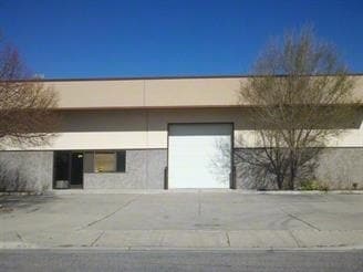


Property Detail
4950 Valenty Rd
RCBPT000300
S3-T6S-R34ES2 TRACT 2 0.44 AC TRACT 3 0.89 AC BOISE PAYETTE TRACTS
Commercialnec
BANNOCK
B and X Area of moderate flood hazard, usually the area between the limits of the 100-year and 500-year floods.
Idaho
2025
1.35 AC
2025
Other Market Areas
000301
Pocatello, ID
NEARBY LISTINGS FOR SALE OR LEASE
DEMOGRAPHICS near 4950 Valenty Rd
1 mile
3 mile
5 mile
2025 Total Population
9,714
47,524
72,452
2030 Population
10,078
49,342
75,065
Pop Growth 2025-2030
+ 3.75%
+ 3.83%
+ 3.61%
Average Age
37
37
37
2025 Total Households
3,586
17,177
27,238
HH Growth 2025-2030
+ 3.85%
+ 3.94%
+ 3.70%
Median Household Inc
$69,348
$76,938
$68,322
Avg Household Size
2.70
2.70
2.60
2025 Avg HH Vehicles
2.00
2.00
2.00
Median Home Value
$354,956
$343,023
$332,607
Median Year Built
1998
1982
1976
Nearby Places
Map Layers
Map Styles
 Street
 Aerial
Layers
 Traffic
 Biking
Places
Listings with unknown addresses are not visible on the map
- Restaurants
- Banks
- Shops
- Fitness
- Groceries
Nearby Properties
Address
Land Use
TOTAL SIZE
Lot Size
Zoning
Address
Land Use
TOTAL SIZE
Lot Size
Zoning
17.10 AC
Address
Land Use
TOTAL SIZE
Lot Size
Zoning
25.10 AC
Address
Land Use
TOTAL SIZE
Lot Size
Zoning
19.02 AC
Address
Land Use
TOTAL SIZE
Lot Size
Zoning
Address
Land Use
TOTAL SIZE
Lot Size
Zoning
28.61 AC
Address
Land Use
TOTAL SIZE
Lot Size
Zoning
6.11 AC
Address
Land Use
TOTAL SIZE
Lot Size
Zoning
14.20 AC
Address
Land Use
TOTAL SIZE
Lot Size
Zoning
Address
Land Use
TOTAL SIZE
Lot Size
Zoning
9.61 AC
Address
Land Use
TOTAL SIZE
Lot Size
Zoning
12.80 AC
Address
Land Use
TOTAL SIZE
Lot Size
Zoning
12.59 AC
Address
Land Use
TOTAL SIZE
Lot Size
Zoning
13.71 AC
Address
Land Use
TOTAL SIZE
Lot Size
Zoning
6.40 AC
Address
Land Use
TOTAL SIZE
Lot Size
Zoning
Address
Land Use
TOTAL SIZE
Lot Size
Zoning
12.95 AC
Address
Land Use
TOTAL SIZE
Lot Size
Zoning
4.62 AC
Address
Land Use
TOTAL SIZE
Lot Size
Zoning
2.85 AC
Address
Land Use
TOTAL SIZE
Lot Size
Zoning
Address
Land Use
TOTAL SIZE
Lot Size
Zoning
9.08 AC
Address
Land Use
TOTAL SIZE
Lot Size
Zoning
13.12 AC
Address
Land Use
TOTAL SIZE
Lot Size
Zoning
Address
Land Use
TOTAL SIZE
Lot Size
Zoning
138.91 AC
Address
Land Use
TOTAL SIZE
Lot Size
Zoning
Address
Land Use
TOTAL SIZE
Lot Size
Zoning
Address
Land Use
TOTAL SIZE
Lot Size
Zoning
5.63 AC
Address
Land Use
TOTAL SIZE
Lot Size
Zoning
11.50 AC
Address
Land Use
TOTAL SIZE
Lot Size
Zoning
50.75 AC
Address
Land Use
TOTAL SIZE
Lot Size
Zoning
1.64 AC
The World's #1 Commercial Real Estate Marketplace
Connect with us
© 2026 CoStar Group
The information above has been obtained from sources believed reliable. While we do not doubt its accuracy we have not verified it and make no guarantee, warranty or representation about it. It is your responsibility to independently confirm its accuracy and completeness. Any projections, opinions, assumptions, or estimates used are for example only and do not represent the current or future performance of the property. The value of this transaction to you depends on tax and other factors which should be evaluated by your tax, financial, and legal advisors. You and your advisors should conduct a careful, independent investigation of the property to determine to your satisfaction the suitability of the property for your needs.